
Avenc Desenrocat dels Castellans
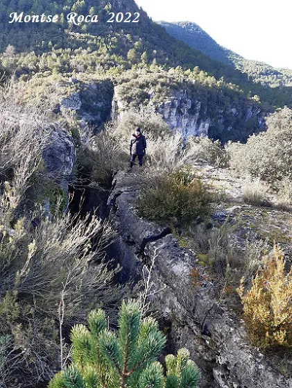
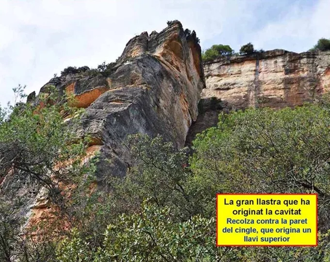
A large fissure 27 m deep and 132 m long in la Febró, at the Desenrocat dels Castellans, between the valleys of the riu del Gorg and the riu de la Febró.
EspeleoWorld
Avenc Desenrocat dels Castellans
A large fissure 27 m deep and 132 m long in la Febró, at the Desenrocat dels Castellans, between the valleys of the riu del Gorg and the riu de la Febró.
Febró, La · Baix Camp
Length: 132 m · Depth: 27 m
Updated record
https://espeleoworld.com/en/c/avenc-desenrocat-dels-castellans
Information can change. Always verify coordinates, access, weather, and cave conditions before setting out.
A large fissure 27 m deep and 132 m long in la Febró, at the Desenrocat dels Castellans, between the valleys of the riu del Gorg and the riu de la Febró.
Topographic

Espeleoindex · CC BY-NC 4.0, https://creativecommons.org/licenses/by-nc/4.0/ · Image © its author.
Photos
Espeleoindex · CC BY-NC 4.0, https://creativecommons.org/licenses/by-nc/4.0/ · Image © its author.
Description
Morphology
We are faced with a fissure more than a hundred metres long that develops in the place known as Desenrocat dels Castellans, between the valleys of the riu del Gorg and the riu de la Febró. The total length is 132 metres, with a width of between 1 and 3.5 metres, except for the lateral fissure that reaches the lowest point, which has an average width of 0.50 metres. The depth is 27 metres.
Progression
At the point of the indicated coordinates, the upper part of the fissure is narrow enough to be able to pass to the other side; here we find a parabolt that, with a 10-metre rope, allows us to descend to the base of the fissure. Continuing E, a steep descent takes us to the end of the fissure, which opens out into the precipice above the riu del Gorg. If, on the other hand, we head W, we soon come to a step where there is a parabolt that, with a 5-metre rope, puts us back at the base of the fissure; from here a steep climb takes us to the highest point of the fissure, only a couple of metres from the outside, but on the other hand it is the most thickly vegetated part, its access from this place being more complicated. The fissure descends again to another easily overcome step; on reaching the lowest point, on the left a narrow joint opens that descends between ramps and small steps (it was installed with multi-monti bolts) and that reaches the lowest point of the fissure at -27 metres. Back at the base of the main fissure, this climbs up until it opens out into the precipice above the riu de la Febró.
History
A pit known since long ago but never recorded in any speleological catalogue. During the exploration carried out in February 2022 inside, remains of military supplies have been found; from the expiry date of these we suppose that they must have been thrown from above by soldiers who must have been on manoeuvres in the area when the military camp of los Castillejos in la Mussara still existed.
In 1967 Albert Manent mentions it in “Toponímia del terme municipal de la Febró”, where he quotes: Es un avenc que s'esbalçà i els enderrocs caigueren al Riu Siurana i esclafaren la sèquia dels Quatre Molins. L'avenc per tant, ha quedat al descobert. A la Febró diuen que durant una guerra que suposem que devia ésser la de Successió hi tiraren vius uns presoners. Algú fa pocs anys, encara hi havia trobat cranis i pots de pólvora. Els presoners, segons la tradició del poble, parlaven estranger (belga diuen uns). L'alcalde que els feu llançar dins l'avenc, anys després cercant un cabrit caigué al mateix lloc i hi mori. La gent ho considerà com un càstig. (sic)
User Comments (0)
No comments yet.
Be the first to share your experience!
Registered Explorations (0)
No explorations registered yet.
Register your visit to this cave!
Bibliography
- Dades inèdites, coordenades, situació, topografia i fotografies facilitades per Montse Roca, Juli Serrano (SIE-CEA) i Francesc Rubinat (ERE-CEC).
- Albert Manent (1967).- Toponímia del terme municipal de la Febró. (Premi Eduard Brossa 1968 de la Societat Catalana de Geografia). Butlletí Arqueològic. Reial Societat Arqueològica Tarraconense, 1973, Núm. 121-128, p. 163-192,
Nearby caves


Source: Espeleoindex (espeleoindex.com), modified. CC BY-NC 4.0, https://creativecommons.org/licenses/by-nc/4.0/