
Field notes · research
Can LiDAR help us find cave entrances?
We tested whether the shape of the ground could help prioritize the search for cave entrances. The signal is promising in some areas, but a hollow on a map is still a question to investigate.
EspeleoWorld ·
Experimental · no new cave confirmed
Start with the surface
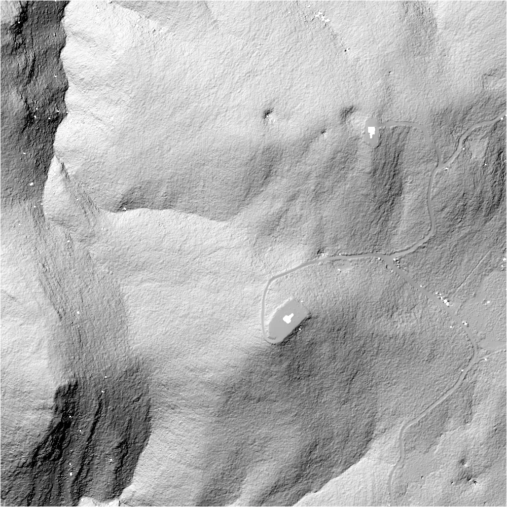
Garraf terrain from the original experiment: a 1 m grid derived from classified ground returns. Hollows, tracks and data gaps share the same image; dark pixels are not proof of an entrance.
© ICGC · CC BY 4.0 · EspeleoWorld
A shortlist, before a discovery
Could we rank small depressions from terrain alone, then see how many known cave entrances appeared near the top? Our pilot uses fixed rules rather than a trained model. Its evaluation uses fixed geographic windows, an explicit distance tolerance and a capped review list.
We used ICGC’s 2021–2023 raw LiDAR and a historical snapshot of 4,434 cave records. That snapshot supplied reference coordinates, not current field verification. Raw files stay on the Mac Mini’s external drive; the article uses the saved results and derived imagery.
Explore the experiment
Pan, zoom and click a point. This map shows the original 12 development windows: 925 unverified terrain candidates and 162 historical reference coordinates. The new-region results below are a separate test.
Loading map…
From laser returns to ranked terrain
- 01
Keep class-2 ground points and build a 1 m elevation grid. Fill empty cells only within 2 m of measured cells. A finer grid alone would not create more measured detail.
- 02
Look for closed basins and local low points relative to 11 m and 31 m surroundings. Process the central 800 × 800 m of each tile, retaining surrounding terrain as context.
- 03
Rank detector agreement, basin depth and local relief using fixed rules. Known-cave proximity never enters a candidate’s score; it is measured only after ranking.
- 04
Evaluate the ranked list against historical entrance coordinates, using explicit distance tolerances and a fixed review cap. Unmatched candidates remain unverified, rather than becoming false positives or discoveries.
The first 12 windows covered 7.68 km² across Garraf, Ordal, Sant Llorenç del Munt and Montsant, with 162 reference coordinates and 925 candidates. The original top-25 lists reached 36/162 references within 25 m. We then compared three variants on those same development windows, froze the choice, and tested six previously unused windows.
The selected revision reduced the excluded margin around missing data from 30 m to 10 m and applied mild penalties to tiny or large basins and broad local relief. The 1 m grid and 2 m maximum fill distance stayed unchanged. This choice was frozen before the new-region test.
What happened on new ground?
The new windows covered 3.84 km² in three massifs and contained 75 documented reference entrances. A hit means at least one ranked candidate within 25 m of a reference coordinate. These are retrieval results, not the percentage of candidates that are real caves.
Original rules
21/7528.0%
Revised rules
25/7533.3%
With up to 25 candidates per window, retrieval rises from 28.0% to 33.3%. The original lists contain 112 candidates; the revised lists contain 150. Reviewing more terrain is part of that difference.
| Massif | Reference entrances | Original rules | Revised rules |
|---|---|---|---|
| Muntanyes de Prades | 37 | 18 | 21 |
| Els Ports | 22 | 3 | 2 |
| Alta Garrotxa | 16 | 0 | 2 |
Prades improved, Els Ports regressed, and Alta Garrotxa remained difficult. The equal-weight average across the three massifs rose from 20.8% to 26.1%. One detection can sit near multiple recorded entrances; the stricter one-to-one total rose from 19 to 22 at this cap.
A persistent depression is not yet a cave
We reviewed five selected Garraf leads on screen; none became a confirmed cave. One compact basin persisted when we changed the grid and interpolation. Its original depth was about 1.03 m over 31 m²; linear triangulation gave 0.74 m over 21 m², and removing the two lowest nearby returns still left 0.59 m over 17 m². Those are surface-basin measurements, not cave depths. All checks share the same acquisition and classification.
What the numbers cannot tell us
We deliberately selected cave-rich windows, so this is not representative Catalunya-wide accuracy. Historical coordinates may be displaced; cliff entrances, narrow fissures and small openings may leave little depression signal. Data gaps, interpolation and human-made basins can mislead the detector. There has been no independent field confirmation, and no candidate-precision or statistical-significance claim.
Where the next iteration should look
Test fissure-sensitive detection, improve ranking, and use land-use context to review road drains and managed basins. Keep raw-point and alternative-gridding checks in the process. The six test windows are now observed evidence: further tuning needs fresh geography. For now, our public feature is the LiDAR map layer; automated cave guessing remains a research experiment.