
Avenc del Mas de la Barba
Cavitat per despreniment de cingle a Cornudella del Montsant
EspeleoWorld
Avenc del Mas de la Barba
Cavitat per despreniment de cingle a Cornudella del Montsant
Cornudella de Montsant · Priorat
Length: 72 m · Depth: 52 m
Updated record
https://espeleoworld.com/en/c/avenc-del-mas-de-la-barba
Information can change. Always verify coordinates, access, weather, and cave conditions before setting out.
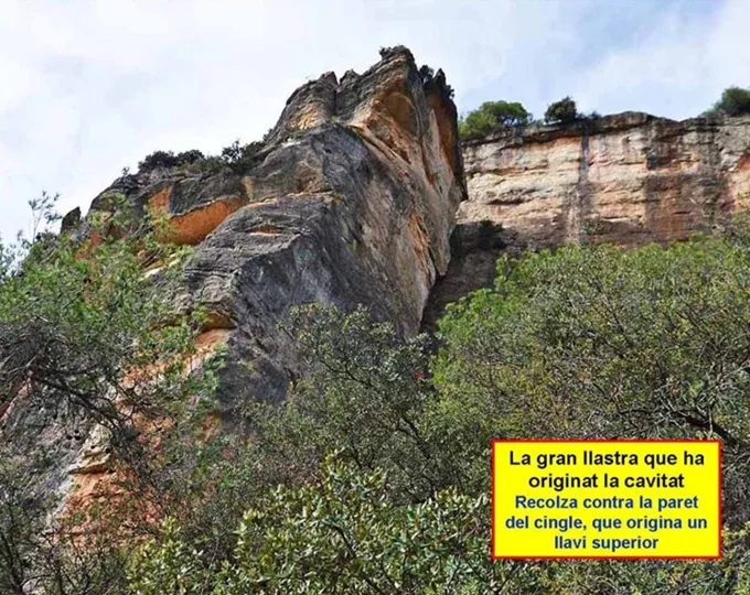
A cavity formed by the detachment of a cliff at Cornudella del Montsant, 230 m SE of the mas de la Barba, in a large slab detached from the cliff of the barranc de la Gritella.
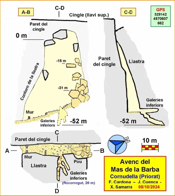
Topographic

Espeleoindex · CC BY-NC 4.0, https://creativecommons.org/licenses/by-nc/4.0/ · Image © its author.
Photos

Espeleoindex · CC BY-NC 4.0, https://creativecommons.org/licenses/by-nc/4.0/ · Image © its author.
Description
Morphology
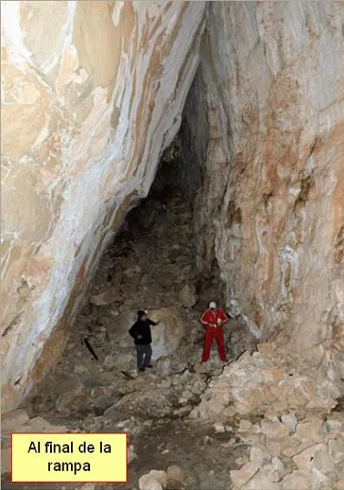
The cavity develops in the space formed between the wall of the cliff and a large slab detached from the cliff that rests slightly inclined upon it. It is an enormous slab; its height is of the order of 60 m, the width of the slab being about 35 m at the base, although it progressively diminishes in height until it is reduced to half at its upper part. Given that the slab has had a vertical component in its displacement, its upper part remains below the level of the cliff, so that the latter forms an upper lip.
Access is via the south entrance, where we find a small wall that indicates to us that at another time the cavity was used by man, perhaps to keep livestock there. After a slightly ascending route, we reach an accumulation of large blocks. The accumulation presents itself vertically, for which reason it is not possible to climb it except by using climbing techniques. Some blocks are wedged between the wall of the cliff and the slab, hanging at great height. Between the blocks some passages are formed and even some pits between the blocks and the slab. Given the dimensions of the entrance, the cavity is illuminated. Where light is needed is in the lower galleries. These are born from the right side of the cavity at floor level. They have a descending layout and it is here that the maximum depth of the cavity is reached, -52 m.
As for the route of the cavity, it has been established at 72 m, of which 28 m correspond to the lower galleries. However, this route could be increased if one wishes to take into account the possible passages between blocks to which no access has been made.
The survey was carried out from the floor of the cavity, using laser distance meters and triangulations to measure the heights and was complemented with a visit to the upper part in order to finish profiling the shapes and the elevations. It is worth saying that it is not easy to deduce the existence of the cavity from the upper part, given that the cliff forms an upper lip from which it is not easy to guess what is directly below.
History
Cavity speleologically unpublished.
The authors of the record became aware of its existence on reading the description of a hiking itinerary that passed by the cavity. From its reading it emerged that it was a fissure accessed from its lower part, but it gave few details about its situation.
After a first attempt at locating it, in 2021, they did not try again until early October 2024, also with null results but with a better knowledge of the terrain, which allowed them a few days later, by a safer but longer itinerary, to reach the cavity and carry out the cataloguing work.
User Comments (0)
No comments yet.
Be the first to share your experience!
Registered Explorations (0)
No explorations registered yet.
Register your visit to this cave!
Bibliography
Totes les dades, topografia i fotografies han estat extretes del web: geb.cat (del Grup d'Espeleologia de Badalona). Apunt del 21-10-2024. Dades: Ferran Cardona (ECM Barcelonès), Josep Cuenca i Xavier Samarra (GE Badalona)
Nearby caves
Cova de les Núvies
0.5 km · SE
Cornudella de Montsant (Priorat)
1 topo.8 photos
Cova Tosca
1.2 km · SW
Cornudella de Montsant (Priorat)
1 topo.3 photos
Cova de Porta-lloret
1.2 km · SW
Cornudella de Montsant (Priorat)
3 topo.4 photos
Avenc Desenrocat dels Castellans
1.2 km · E
Febró, La (Baix Camp)
2 topo.14 photos
Source: Espeleoindex (espeleoindex.com), modified. CC BY-NC 4.0, https://creativecommons.org/licenses/by-nc/4.0/