
Cova de Porta-lloret
Cova de 72 m de recorregut al vessant esquerre del riu Siurana (Cornudella de Montsant)
EspeleoWorld
Cova de Porta-lloret
Cova de 72 m de recorregut al vessant esquerre del riu Siurana (Cornudella de Montsant)
Cornudella de Montsant · Priorat
Length: 72 m · Depth: 17 m
Updated record
https://espeleoworld.com/en/c/cova-de-porta-lloret
Information can change. Always verify coordinates, access, weather, and cave conditions before setting out.
A 72 m long cave on the left bank of the Siurana river, in Cornudella de Montsant, discovered in 1934 and excavated until 1952.
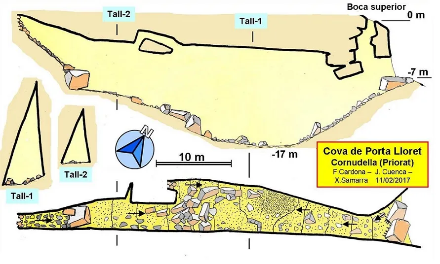
Topographic

Espeleoindex · CC BY-NC 4.0, https://creativecommons.org/licenses/by-nc/4.0/ · Image © its author.
Photos

Espeleoindex · CC BY-NC 4.0, https://creativecommons.org/licenses/by-nc/4.0/ · Image © its author.
Description
Morphology
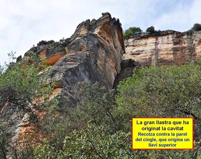
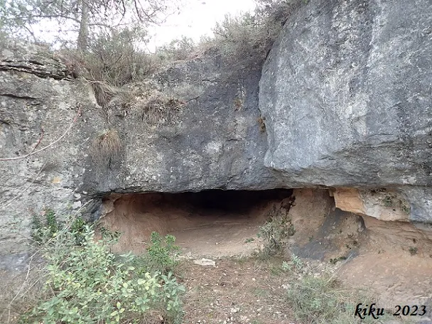
The entrance opens in a corner at the foot of the cliff. It is of a good size, but some large blocks form a step that is overcome by passing under the block on the right. 7 metres above the main entrance there is another entrance that had never been indicated in the topographies prior to that of 2017 (ECG; GEB).
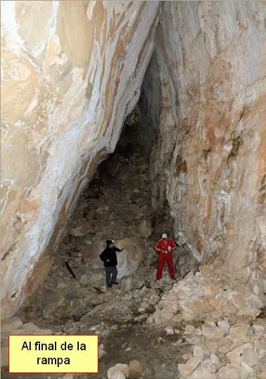
It gives way to a straight gallery of triangular section, initially descending, which increases in size until reaching the central sector, where 7 metres in width by 14 in height are reached. From here it becomes ascending, with some quite large block chaos. A large slab detached from the right wall narrows the width of the gallery and, further on, one must overcome a large block to reach the terminal sector, the cavity ending obstructed by blocks.
The cavity develops parallel to the cliff. In fact, the north wall (right) is an enormous slab displaced from the cliff that has slid along its base and has come to rest with its upper part against the south wall. As a consequence of this, we have a cross-section of triangular shape, taller than it is wide, and on the ceiling the line of discontinuity between the north wall (mobile) and the south wall (static) is perfectly reflected.
Blocks are abundant, notably a secondary slab detached from the north wall that also rests against the south wall with its upper part.
Progression
The entrance opens in a corner at the foot of the cliff. It is of a good size, but some large blocks form a step that is overcome by passing under the block on the right. 7 metres above the main entrance there is another entrance that had never been indicated in the topographies prior to that of 2017 (ECG; GEB).
It gives way to a straight gallery of triangular section, initially descending, increasing in size until reaching the central sector, where 7 metres in width by 14 in height are reached. From here it becomes ascending, with some quite large block chaos. A large slab detached from the right wall narrows the width of the gallery and, further on, one must overcome a large block to reach the terminal sector, the cavity ending obstructed by blocks.
Other details
In the deepest zone materials dated from the Chalcolithic to the final Bronze Age – Iron I were found.
History
Discovered in 1934 by Mr. Josep Porta, then schoolmaster of Arbolí. That same year the excavations directed by Salvador Vilaseca began with the participation of the discoverer; of Mr. Josep Lloret, then schoolmaster of Alforja and discoverer of several cavities in the Arbolí area, and of Mr. Manuel Mata, of Reus. The work was carried out in different stages until 1952, when it was considered finished. Members of the Excursionist Section of the Centre de Lectura de Reus also participated.
User Comments (0)
No comments yet.
Be the first to share your experience!
Registered Explorations (0)
No explorations registered yet.
Register your visit to this cave!
Bibliography
- Borràs, J.; Miñarro, JM.; Talavera, F. (1984).- Catàleg espeleològic de Catalunya. Vol. 7 (el Baix Camp, el Priorat i la Ribera d'Ebre. Políglota: 283 pp. Barcelona.
- Vilaseca, S. (1958).- “La cueva de Porta-Lloret en el antiguo término de Siurana, Montes de Prades”. Ampurias (XIX-XX): 104-114 Museo de Arqueologia. Barcelona. Actualització de dades, topografia (2017) i fotografies extretes del web: geb.cat (GE Badalona). Apunt del 20 de febrer del 2017.
- Dades fitxa actualitzada: F. Cardona (ECG); J. Cuenca i F.X. Samarra (GEB)
Nearby caves
Cova Tosca
0.0 km · E
Cornudella de Montsant (Priorat)
1 topo.3 photos
Cova del Cingle del Bodro
0.1 km · W
Cornudella de Montsant (Priorat)
1 topo.4 photos
Avenc del Mas de la Barba
1.2 km · NE
Cornudella de Montsant (Priorat)
1 topo.6 photos
Cova de les Núvies
1.2 km · NE
Cornudella de Montsant (Priorat)
1 topo.8 photos
Source: Espeleoindex (espeleoindex.com), modified. CC BY-NC 4.0, https://creativecommons.org/licenses/by-nc/4.0/