
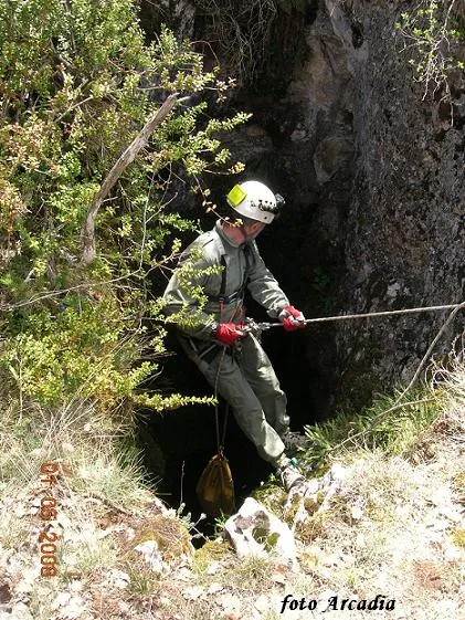
Forat dels Diners
Cavitat de 29 m de desnivell i 182 m de recorregut al municipi de Gavet de la Conca.
EspeleoWorld
Forat dels Diners
Cavitat de 29 m de desnivell i 182 m de recorregut al municipi de Gavet de la Conca.
Gavet de la Conca · Pallars Jussà
Length: 182 m · Depth: 29 m
Updated record
https://espeleoworld.com/en/c/forat-dels-diners
Information can change. Always verify coordinates, access, weather, and cave conditions before setting out.
A cavity with 29 m of vertical extent and 182 m of passage in Gavet de la Conca, with a hall of 36x14x13 m, an artificial shaft 3 m deep and 6 m wide, and an upper gallery of 40 m. Documented since 1891 and explored speleologically in 1966.
Topographic
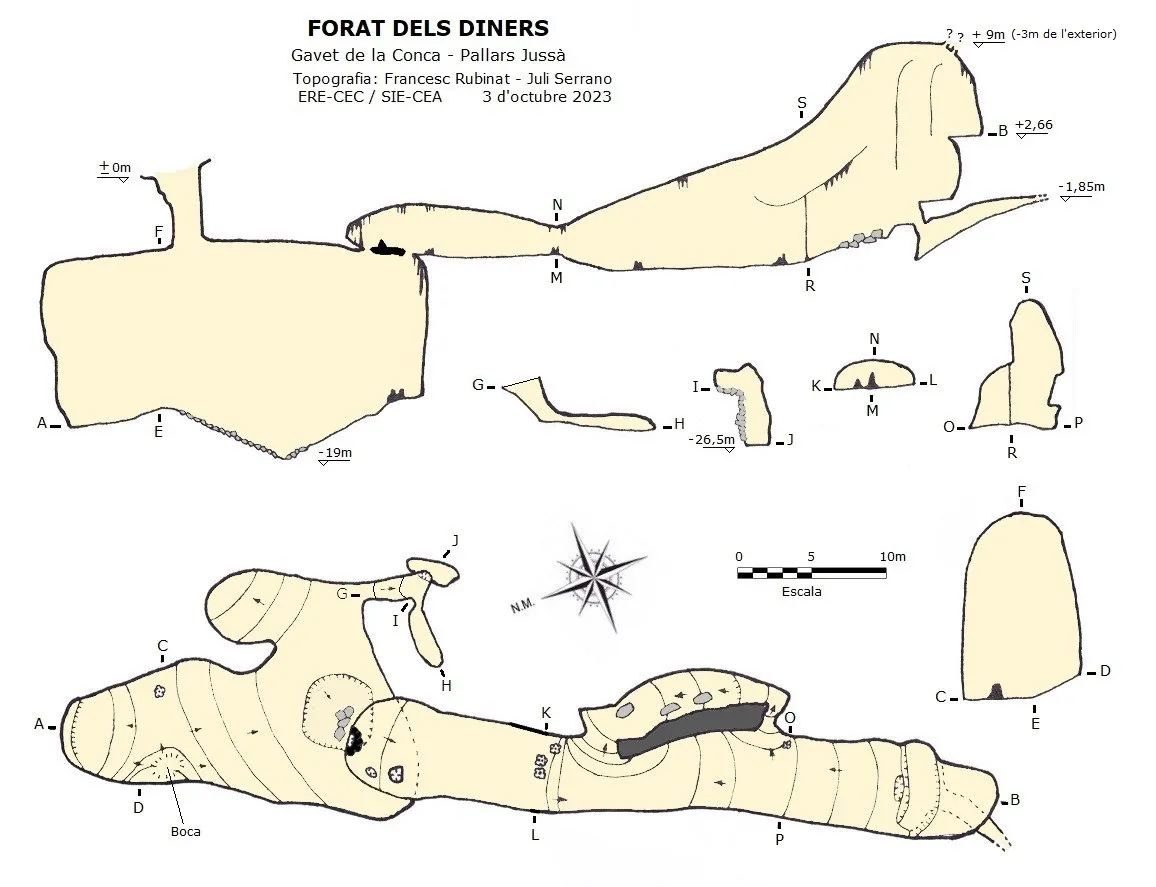

Espeleoindex · CC BY-NC 4.0, https://creativecommons.org/licenses/by-nc/4.0/ · Image © its author.
Photos

Espeleoindex · CC BY-NC 4.0, https://creativecommons.org/licenses/by-nc/4.0/ · Image © its author.
Description
Morphology
The entrance shaft, 3 metres, cuts into the vault of a hall of 36x14x13 metres. In the centre of the hall there is a shaft of about 3 metres deep by 6 metres wide made artificially. On the SE side of the hall we find some small passages with small ledges and quite muddy that take us down to the level of -26.5 metres. On the SW side of the hall, above the hole in the floor in the middle of it, we find some large stalagmites where a fixed rope arrives that comes from the ceiling (its use is under personal responsibility, since it has no safety guarantee). Once at the ceiling, through a narrow passage one accesses a gallery of notable dimensions and about 40 metres of passage with plenty of formation; the gallery ends at a point where we find another rope that climbs about ten metres up to the upper part of the gallery. On the ceiling we find many roots due to the proximity to the exterior. In the lower part of this point there is a narrow passage that allows one to go a few more metres, and parallel to the main gallery we find some smaller passages that connect with the main gallery at various points. The vertical extent of the cavity is 29.1 m (-26.5/+2.6); and 182 metres of passage. The final point of the gallery at the ceiling is at the level of +9 metres, exactly 3 metres from the exterior; the coordinates at this point are ETRS89 334587 – 4655009 and 1176 m a.s.l. The exterior height at this point is 1179 m a.s.l.
Speleothems
On the SW side of the hall we find some large stalagmites. The upper gallery has plenty of formation.
Progression
The entrance shaft cuts into the vault of a hall. On the SE side of the hall, some small passages with small ledges and quite muddy descend to the level of -26.5 metres. On the SW side, above the hole in the floor, there is a fixed rope that comes from the ceiling (its use is under personal responsibility, since it has no safety guarantee). Once at the ceiling, through a narrow passage one accesses an upper gallery. The gallery ends at a point where another rope climbs about ten metres up to the upper part. In the lower part of this point there is a narrow passage that allows one to go a few more metres.
History
It is documented that in January 1891 a certain Jaume Climent, supposedly from Tremp, requests a concession for a gold mine that they call mina Natividad at the place named as Forat dels Diners, where he asks for 8 parcels (80,000 square metres) located in the municipality of Sant Salvador de Tolò (currently Gavet de la Conca). Once all the administrative procedures were completed, on 18 December 1891 the civil governor of Lleida sends to the chief of mining engineers of the province to make the demarcation of the requested area; the chief engineer turns out to be Lluís Marià Vidal, he draws up a record of the demarcation citing that the first point is marked at 7.3 metres and 200 degrees from the centre of the shaft or vertical cave of the Forat dels Diners, noting in the record that neither the applicants nor anyone representing them were present and three witnesses sign. On 27 December 1891 Lluís Marià Vidal delivers the plans and documentation to the civil government. On 4 February 1892 the civil governor issues an edict so that the applicant makes the payment established for the concession of the mine; this payment was never made and after various unsuccessful searches for this person, finally on 11 October 1892 the civil governor declares the mining concession expired. The doubt that remains is whether the drill holes that are observed at the entrance shaft were made by the applicants for the gold mine permit without being certain that they would be granted the exploitation, which surprises us. Or perhaps these had been made years earlier as the owner of the Hostal Roig explained in 1978. According to him, his ancestors called the hole Forat de les Gralles, and it was a narrow crack through which only jackdaws passed, but at some times of the year damp vapour came out from the interior, so they blasted the passage to see if they would find water inside; finding nothing they began to call it forat dels Diners, those who had spent for nothing. The first speleological exploration of which there are data was carried out by A.G. Cairol, R. Alsina and J. Griera, during the days 11 to 15 August 1966, these belonging to the GIE of the Club Excursionista de Gràcia. In 1978 Francesc Rubinat with other members of the GEFOMA, whom the owner of the Hostal Roig, who at that time was already an elderly person, accompanied to the hole, explained to them that his parents in the 19th century already knew the hole; these make the only topography that was known of the cavity until 2023. In 2018 members of the GESAM de Tremp observe a forat negre in the ceiling intuiting a continuity, but it is not until 2022 that members of the GESAM de Tremp and of the GREC de Barcelona carry out a climb of about 13 metres at a point in the hall and access an upper gallery of good dimensions with many formations. Later, in a collective interclubs activity in which members of the (GESAM), (SEPS del FEB), (ECMB), (GELL del CEL) and (GEPS) participate, they finish forcing a couple of passages and take the topographic data carrying out a topography that they make known in 2023. In 2023 Francesc Rubinat (ERE-CEC) and Juli Serrano (SIE-CEA) carry out a couple of outings to the cavity and carry out a new topography to complement the topography carried out by one of them 45 years earlier.
Bio
Speonomus puncticollis jeann.
Troglocharinus hustachei jeann.
Coleoptera catopidae subfamilia bathysciinae.
Collected by F. Rubinat and J. Ametller on 9 December 1978.
User Comments (0)
No comments yet.
Be the first to share your experience!
Registered Explorations (0)
No explorations registered yet.
Register your visit to this cave!
Bibliography
- Borràs, J.; Miñarro, J.M.; Talavera, F.(1979).-”el pallars jussà”. Catàleg Espeleològic de Catalunya (vol.3):73-76. Edit. Políglota. Barcelona.
- Cairol,A.G; Alsina, R.; Griera, J. (1966).-”Espeleología en el Montsec de Rubies”. Circular C E Gràcia (292):151-153. CE Gràcia. Barcelona.
- Escolà i Boada, Oleguer. (1970).-”Catálogo Espeleológico del Montsec”. Espeleòleg (10-11):453-538. ERE-CEC. Barcelona.
- Rubinat, F. (1979).- “Por un mejor conocimiento del Montsec de Rubies” GOURS (6):13-39. GEFOMA. Barcelona.
- Valles, Jordi de. (2008).-”Alta Ribagorça, Pallars Jussà, Pallars Sobirà, Val d'Aran”. Catàleg Espeleològic de Catalunya (vol.1):96-97. ECG/FCE.
- Arxiuenlinia.cultura.gencat.cat
- Dades actualitzades del descobriment de la galeria superior, nova topografia aportada per Joaquim Castaño (†), Jordi Pascual (SAM) i Jordi Ferreras (GREC), fotografies galeria superior de Juan C. Gómez i Josep Blasco, actualitzat el març de 2023.
- Topografia, dades i fotografies facilitades per Juli Serrano (SIE-CEA) i Francesc Rubinat (ERE-CEC) actualitzat el novembre de 2023.
Nearby caves
Avenc Nº1 de les Forques
0.3 km · N
Gavet de la Conca (Pallars Jussà)
1 topo.2 photos
Escletxa de les Forques
0.4 km · N
Gavet de la Conca (Pallars Jussà)
1 topo.2 photos
Avenc Nº2 de les Forques
0.4 km · N
Gavet de la Conca (Pallars Jussà)
1 topo.2 photos
Forat del Camí Nou
0.6 km · N
Gavet de la Conca (Pallars Jussà)
1 topo.4 photos
Source: Espeleoindex (espeleoindex.com), modified. CC BY-NC 4.0, https://creativecommons.org/licenses/by-nc/4.0/