
Espluga dels Tres Pilars
A 15-metre-deep rock shelter in Odèn, on the right bank of the riera de Canalda, known in the area since time immemorial.
EspeleoWorld
Espluga dels Tres Pilars
A 15-metre-deep rock shelter in Odèn, on the right bank of the riera de Canalda, known in the area since time immemorial.
Odèn · Solsonès
Length: 15 m
Updated record
https://espeleoworld.com/en/c/espluga-dels-tres-pilars
Information can change. Always verify coordinates, access, weather, and cave conditions before setting out.
A 15-metre-deep rock shelter in Odèn, on the right bank of the riera de Canalda, known in the area since time immemorial.
Topographic
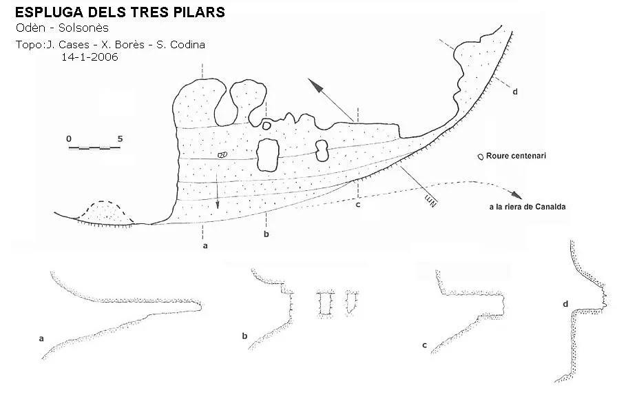
Espeleoindex · CC BY-NC 4.0, https://creativecommons.org/licenses/by-nc/4.0/ · Image © its author.
Description
Morphology
It is a large rock shelter excavated in the crag, 15 metres deep. Formerly, when the level of the riera passed over this spot, the weaker materials were eroded in a curious way, leaving three columns. The material forming them is like a red clay and sandstone that breaks down into more or less spherical and fairly compact nodules, while on the ceiling and floor there are conglomerates. It is curious to see how the three pillars support the long flat conglomerate ceiling and reinforce it.
Hydrology
Inside it, water still springs after the rain, and plants take advantage of this to live and seek the light towards the outside.
History
Known in the area since time immemorial.
User Comments (0)
No comments yet.
Be the first to share your experience!
Registered Explorations (0)
No explorations registered yet.
Register your visit to this cave!
Bibliography
- Codina, Salvador.(2008).-”Balma dels Tres Pilars”. Corriol (149):12-13. Centre Excursionista del Solsonès.
- Valles, Jordi de. (2009).-”Alt Urgell, Noguera, Pla d'Urgell, Segarra, Solsonès, Urgell” Catàleg Espeleològic de Catalunya (2):365. EC Gràcia/FCE.
Nearby caves


Source: Espeleoindex (espeleoindex.com), modified. CC BY-NC 4.0, https://creativecommons.org/licenses/by-nc/4.0/