
Espluga del Castell de la Clua
Balma fortificada a la Clua (Artesa de Segre).
EspeleoWorld
Espluga del Castell de la Clua
Balma fortificada a la Clua (Artesa de Segre).
Artesa de Segre · Noguera
Length: 14 m · Depth: 4 m
Updated record
https://espeleoworld.com/en/c/espluga-del-castell-de-la-clua
Information can change. Always verify coordinates, access, weather, and cave conditions before setting out.
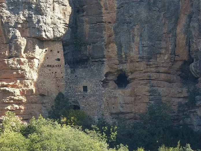
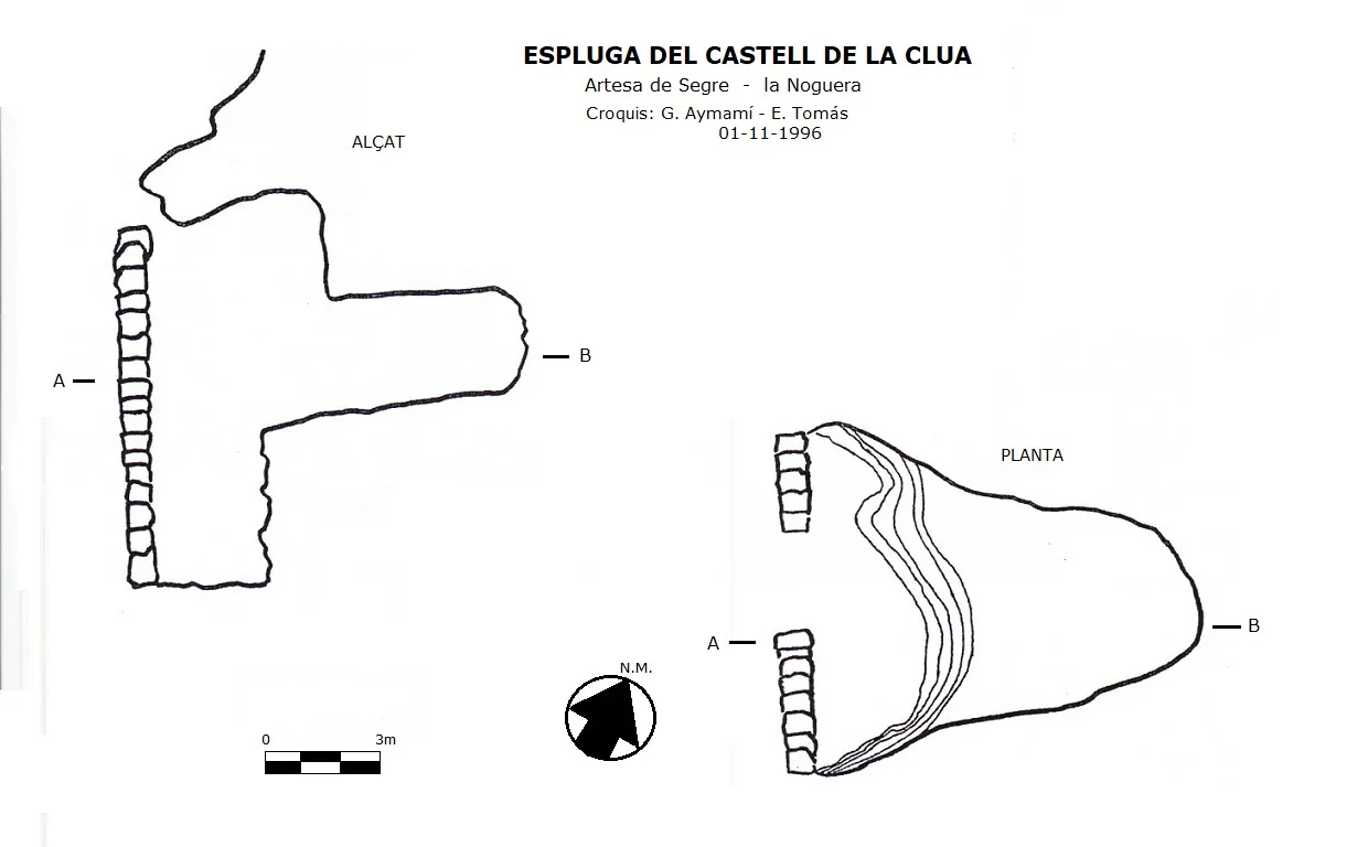
Fortified rock shelter at la Clua (Artesa de Segre), with a wall one metre thick, 8.5 metres long and about 8 metres high, a door 3 metres by 2.5 metres, 10 metres deep and a height of +4 metres.
Topographic

Espeleoindex · CC BY-NC 4.0, https://creativecommons.org/licenses/by-nc/4.0/ · Image © its author.
Photos

Espeleoindex · CC BY-NC 4.0, https://creativecommons.org/licenses/by-nc/4.0/ · Image © its author.
Description
Morphology
The rock shelter is closed by a wall that measures one metre thick, 8.5 metres long and about 8 metres high, where there is a square window, several arrow slits and the door, which has a height of 3 metres with a width of 2.5 metres; this ends in a semicircular arch missing its voussoirs, which were probably reused in modern times in some other construction.
On the wall of the rock shelter several courses of stones can be observed that would undoubtedly help to support the roof, of which no trace remains, as well as the ledges that would have formed the two storeys in height that this fortress would have had. The Balma is 10 metres deep and has a height from the base of +4 metres.
History
The first records of the term date to the year 1059, when Garsenda gave to the monastery of Santa Maria de Meià some vineyards located in la Clua. The castle belonged to the patrimony of the Meià family. In the year 1193, Guillem de Meià in his will left to his sister Ermessenda and to her son, Ramon de Cervera, several castles, among them that of la Clua. In the year 1311, Dolça de Cervera gave the castle of la Clua and the others of the Meià family to her son Pere II d'Ayerbe, who in 1312 exchanged with King Jaume II all his patrimony in Catalonia for several castles located in Aragon. Immediately afterwards, the king incorporated them into the crown. The castle was considered to be located in the marquisate of Camarasa but it does not appear in any document referring to the castles dependent on the infantes Ferran and Martí, possessors of the marquisate. In 1405, Ramon Picó held the castle in fief from the king. The following year the castle was sold by Bernat de Cruïlles. In 1453, the feudatory was Bernat de Vilagaià, who had a conflict over boundaries with the chapter of the Seu d'Urgell. A descendant of his, Miquel de Vilagaià, ordered the sale of the castle of la Clua, which Joana, probably his wife, did in the year 1505, to Pere de Rocaspana together with all civil and criminal jurisdiction.
At the time of the disappearance of jurisdictional lordships, the castle was under the dominion of the noble Gomes.
Roig i Jalpí, in the middle of the 17th century, gives the description of the castle: En el lugar de Clua entre unas peñas, hay un castillo medio habitable.
User Comments (0)
No comments yet.
Be the first to share your experience!
Registered Explorations (0)
No explorations registered yet.
Register your visit to this cave!
Bibliography
- Aymamí i Domingo, Genar (2006).-Coves Fortificades de Catalunya pp:12-15. UEC/FCE.
- Bolòs i Masclans, Jordi; i altres.(1994).-”Castell de la Clua”. Catalunya romànica (XVII):178-179 Enciclopèdia Catalana. Barcelona.
- Valles, Jordi de (2009).-”Alt Urgell, Noguera, Pla d'Urgell, Segarra, Solsonès, Urgell”. Catàleg Espeleològic de Catalunya. (Vol.2):141-142. Espeleo Club de Gràcia / Federació Catalana d'Espeleologia.
- Dades, i fotografia exterior de “pitopito12” extretes de wikiloc.
- Coordenades i fotografies facilitades per Juli Serrano (SIE-CEA) i Francesc Rubinat (ERE-CEC), desembre 2023.
Nearby caves
Avenc del Fusell
1.0 km · NW
Artesa de Segre (Noguera)
1 topo.
Forat del Barranc de la Clua
2.4 km · NW
Artesa de Segre (Noguera)
1 topo.8 photos
Baborell d'en Remigio
3.4 km · SW
Alòs de Balaguer (Noguera)
1 topo.5 photos
Baborell de la Dona Morta
3.7 km · W
Alòs de Balaguer (Noguera)
2 topo.12 photos
Source: Espeleoindex (espeleoindex.com), modified. CC BY-NC 4.0, https://creativecommons.org/licenses/by-nc/4.0/