
Cova de la Punta Des Quart
A 29 m-long sea cave in Palafrugell, with a single gallery and a final stalagmitic flow.
EspeleoWorld
Cova de la Punta Des Quart
A 29 m-long sea cave in Palafrugell, with a single gallery and a final stalagmitic flow.
Palafrugell · Baix Empordà
Length: 29 m · Depth: 3 m
Updated record
https://espeleoworld.com/en/c/cova-de-la-punta-des-quart
Information can change. Always verify coordinates, access, weather, and cave conditions before setting out.
A 29 m-long sea cave in Palafrugell, with a single gallery and a final stalagmitic flow.
Topographic
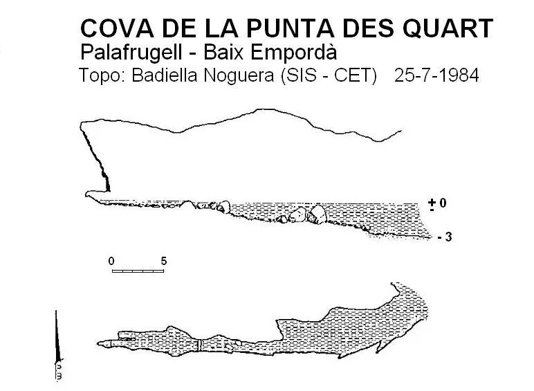
Espeleoindex · CC BY-NC 4.0, https://creativecommons.org/licenses/by-nc/4.0/ · Image © its author.
Description
Morphology
It consists of a single gallery 29 metres long with an entrance 6 metres high, 4 wide and 3 deep below sea level. The dimensions remain constant during the first 13 metres of the route, from which point the gallery narrows to 1 metre, but the height remains almost constant throughout the cavity.
Speleothems
Noteworthy is a stalagmitic flow on the final wall of the cave.
Hydrology
The last stretch is slightly above sea level but remains flooded nonetheless.
History
The only data we know are those provided by members of the SIS – CE Terrassa who explored and surveyed it in July 1984, naming it la Cova de la Punta d'Esguard and which today kayakers know as la Cova de l'Àvia Catalana.
User Comments (0)
No comments yet.
Be the first to share your experience!
Registered Explorations (0)
No explorations registered yet.
Register your visit to this cave!
Bibliography
- Badiella, Enric; Badiella, Xavier; Badiella, Eduard (1992).- “Les cavitats litorals del Baix Empordà. (I) de Palamós a Aiguablava”. SIS (12): 26-51 / Arxiu del Centre Excursionista de Terrassa (75): 162-187. Terrassa.
Nearby caves



Source: Espeleoindex (espeleoindex.com), modified. CC BY-NC 4.0, https://creativecommons.org/licenses/by-nc/4.0/