
Balmes de Montpolt
A 10-metre-long rock shelter in Montpolt (Lladurs), formed by two shelters close together on the S face of the Roca de Montpolt.
EspeleoWorld
Balmes de Montpolt
A 10-metre-long rock shelter in Montpolt (Lladurs), formed by two shelters close together on the S face of the Roca de Montpolt.
Lladurs · Solsonès
Length: 10 m · Depth: 6 m
Updated record
https://espeleoworld.com/en/c/balmes-de-montpolt
Information can change. Always verify coordinates, access, weather, and cave conditions before setting out.
A 10-metre-long rock shelter in Montpolt (Lladurs), formed by two shelters close together on the S face of the Roca de Montpolt.
Topographic
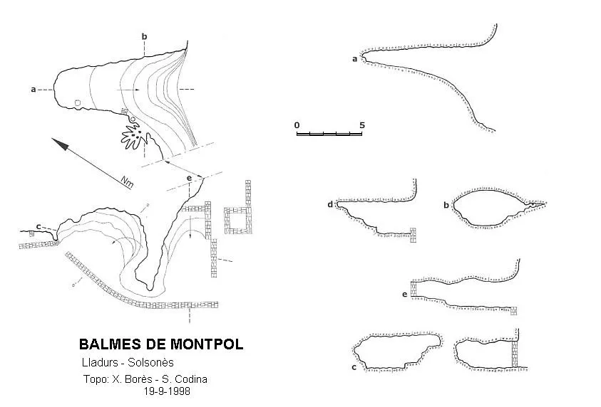
Espeleoindex · CC BY-NC 4.0, https://creativecommons.org/licenses/by-nc/4.0/ · Image © its author.
Description
Morphology
It is really two shelters very close to each other, on the S face of the Mola. The more eastern one is a cave or rock shelter with a spring of water that has gradually enlarged it. It is a little more than 10 metres deep inside, with a steep upward slope at the beginning and gentler at the end, until reaching +6 metres. The mouth is 10 metres wide by 7 metres high, and in the middle part of the shelter the width is 3 metres by 2 metres high.
The more western shelter is formed by two chambers separated by a small passage half a metre wide by 2 metres high. The chamber facing W is about 5 metres deep inside and has a mouth 7 metres wide by 2.50 metres high. The chamber facing S is 7 metres deep with a mouth 4 metres wide by 2 metres high.
Both shelters share a stone wall 13 metres long by 2 high up to the roof of the rock, leaving an entrance at each end, but currently more than half has fallen. Also on the S face, there is another wall about 5 metres long by 2 metres high up to the roof, but it still stands upright, and in front of it we will find in ruins what may possibly be the four walls of an old oven.
Hydrology
The more eastern shelter is a cave or rock shelter with a spring of water that has gradually enlarged it.
History
Known since time immemorial.
User Comments (0)
No comments yet.
Be the first to share your experience!
Registered Explorations (0)
No explorations registered yet.
Register your visit to this cave!
Bibliography
- Codina, S.(2000).-”Balmes de Montpolt”. Corriol (116):12-13. CE Solsonès.
- Valles, Jordi de.(2009).-”Alt Urgell, Noguera, Pla d'Urgell, Segarra, Solsonès, Urgell”. Catàleg Espeleològic de Catalunya (vol.2):328-329. EC Gràcia/FCE.
Nearby caves

Source: Espeleoindex (espeleoindex.com), modified. CC BY-NC 4.0, https://creativecommons.org/licenses/by-nc/4.0/