
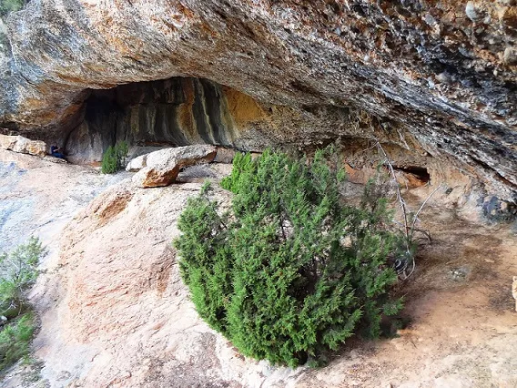
Balma del Xoriguer
A 7-metre-deep rock shelter in Navès, on the right bank of the Cardener, below the Capdevila cliffs and above the Llosa del Cavall dam.
EspeleoWorld
Balma del Xoriguer
A 7-metre-deep rock shelter in Navès, on the right bank of the Cardener, below the Capdevila cliffs and above the Llosa del Cavall dam.
Navès · Solsonès
Length: 7 m
Updated record
https://espeleoworld.com/en/c/balma-del-xoriguer
Information can change. Always verify coordinates, access, weather, and cave conditions before setting out.
A 7-metre-deep rock shelter in Navès, on the right bank of the Cardener, below the Capdevila cliffs and above the Llosa del Cavall dam.
Topographic
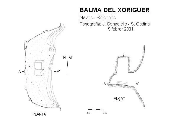
Espeleoindex · CC BY-NC 4.0, https://creativecommons.org/licenses/by-nc/4.0/ · Image © its author.
Photos
Espeleoindex · CC BY-NC 4.0, https://creativecommons.org/licenses/by-nc/4.0/ · Image © its author.
Description
Morphology
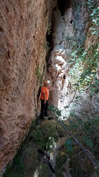
It is really a large shelter in conglomerate rock, and water seepage has gradually enlarged it through block collapses. Its mouth is about 20 metres wide by 3.50 metres high, with a depth of about 7 metres; inside the shelter the vault reaches a height of 7 metres.
Progression
To get there we will start from the hostal del Vent, located on the LV-4241 road from Solsona to Coll de Jou, since it is the only accessible place, because from the dam itself we will find an electrified fence blocking the way. We will go down along the path that passes beside the pool in front of the hostel itself, along the right bank of the head of the gully. At the first junction, we will go down to the left until we cross the Torrenteller gully. We will continue descending along the left bank, beside a wire fence. We will cross the gully again and continue descending to another junction. We will go down to the left and cross the same gully once more. Further on we will pass the fence through the signposted gate, and continue first on a slight climb and then on level ground until we come out on a spur above a cliff line, with a great view over the Torrenteller valley. From here on the way cannot be lost because it follows the strip between the two cliff lines, one above and the other below. The only drawback is that it is not worn. The only ones who pass through are hunters and wild boars. We will descend a little in elevation, cross a small gully and continue on level ground, crossing another gully in a more overgrown spot. From here we will climb through the shady side of the strip, which offers a perspective over the cliffs we have passed. From here we will observe, below the cliffs we have passed, the balma de les Carboneres. We will reach a spur with a large pool that wild boars use to wallow and rub against the pines, we will go down to cross a small stream, and continue climbing gently, trying to follow the green-painted marks because there are some confusing spots, passing below the balmes de la Quesis and de la Corrua respectively. Further up we will pass a few metres from the wall called “la trona”, or “el balcó”, we will continue climbing gently to a spur with a wide view over the Torrenteller valley and the Cardener valley, and then continue on level ground until we pass another spur with a small monolith below it. From here we will descend through a long wooded area with some hundred-year-old oaks, trying to keep more to the side of the cliff than inside the wood. Further on we will cross a small stream, then continue on level ground and keep descending until we cross the Capdevila gully, above a large plunge pool. We will leave the better-marked path and go down beside the gully until we find another path that crosses the same gully a little further down, but we will continue ahead on a slight climb, pass another spur and continue on level ground to the next spur, where there is a rock marked with green paint. From here we will already be able to hear the sound of the water of the Cardener river because we are approaching the dam. The path descends decisively and directly without stopping to above the transformer of the Llosa del Cavall dam. To go to the shelter we will climb through the wood without a path, starting from a pine marked with green paint, trying to head towards the cliff wall to look for a paint mark on the rock that will indicate that we are right below it. Approximate coordinates, not very precise.
Other details
But the most interesting thing is the extraordinary view it has over the Cardener valley and, above all, of the dam. One should also observe «el xerri» left by the livestock, when in the past it was used to pen the flock.
History
Known since time immemorial by the people of the area, and used to shelter flocks. It was explored and surveyed on 9 February 2001 by S. Codina and J. Gangolells (CE Solsonès).
User Comments (0)
No comments yet.
Be the first to share your experience!
Registered Explorations (0)
No explorations registered yet.
Register your visit to this cave!
Bibliography
- Codina, S.(2002).-”Balma de Capdevila”. Corriol (125):10-11. CE Solsonès.
- Codina, S.(2005).-”Ruta espeleològica per la rasa de Capdevila”. Corriol (139):10-11. CE Solsonès.
- Codina, S.(2007).-”Volta per les rases de Torrentaller i Capdevila”. Corriol (144):14-15. CE Solsonès.
- Valles, Jordi de.(2009).-”Alt Urgell, Noguera, Pla d'Urgell, Segarra, Solsonès, Urgell). Catàleg Espeleològic de Catalunya (Vol. 2):370-371. EC Gràcia-FCE.
- Coordenades i fotografies facilitades per Salvador Codina.
Nearby caves



Source: Espeleoindex (espeleoindex.com), modified. CC BY-NC 4.0, https://creativecommons.org/licenses/by-nc/4.0/