

Cau de les Goges
Archaeologically interesting cave in Sant Julià de Ramis, with two entrances, remains of an ancient wall and sediments disturbed by excavations.
EspeleoWorld
Cau de les Goges
Archaeologically interesting cave in Sant Julià de Ramis, with two entrances, remains of an ancient wall and sediments disturbed by excavations.
Sant Julià de Ramis · Gironès
Sviluppo: 21 m · Profondità: 2 m
Scheda aggiornata
https://espeleoworld.com/it/c/cau-de-les-goges-sant-julia-de-ramis
Le informazioni possono cambiare. Verifica sempre coordinate, accesso, meteo e condizioni della cavità prima di partire.
Archaeologically interesting cave in Sant Julià de Ramis, with two entrances, remains of an ancient wall and sediments disturbed by excavations.
Topografia

Espeleoindex · CC BY-NC 4.0, https://creativecommons.org/licenses/by-nc/4.0/ · Immagine © del suo autore.
Foto
Espeleoindex · CC BY-NC 4.0, https://creativecommons.org/licenses/by-nc/4.0/ · Immagine © del suo autore.
Descrizione
Morfologia
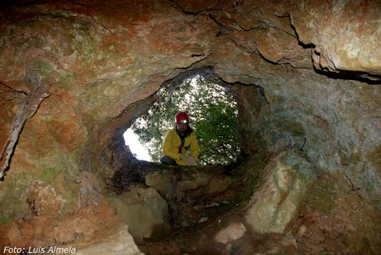
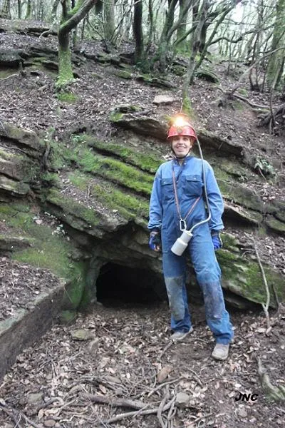
The cavity has two entrances: a lower one 0.7x1 metre in diameter and the upper one 1.6x2.15 m, located to the right of the former and a couple of metres higher.
Progressione
Entering through the lower entrance, this soon gains width and height; at the end, on the right, we find the remains of an ancient stone wall that probably closed the cavity to make it more usable. At this point one enters the gallery that comes from the upper entrance; this is full of blocks and at the final part, below these, we find a good deal of disturbed sediment, we suppose due to the archaeological work that was carried out at the time.
Altri dettagli
Already in the year 1899 stone objects were found there that Manuel Cazurro attributed to the Palaeolithic.
Storia
One must not confuse the Cau de les Goges with la Cova de les Goges; the latter disappeared around the year 1967 due to the works of a new variant of the N-II road. The similarity of the name and the proximity of both caves gave rise to the Cau de les Goges being cited as disappeared in the Catàleg Espeleològic de Catalunya (ed. 1980), when in reality it was la Cova de les Goges that had disappeared. In the Catàleg Espeleològic de Catalunya (ed. 2010) the mistake is maintained, but moreover it is wrongly located in the municipality of Sant Martí de Llémena.
In Catalan mythology the goges are fairies, water women,...
Known since ancient times. Puig y Larraz (1896) calls it Cau de las Gojas and locates it in Sarrià de Ter, based on earlier data by Palol i Vinyes that appeared in the Revista de Gerona. Font i Sagué cites it again in his Catàlech (1897) without providing further data. It is almost certain that this citation corresponds to the disappeared la Cova de les Goges. Font also cites two caves (without specifying a name) in Sant Julià de Ramis, which undoubtedly are the two cavities mentioned and which have erroneously come to be catalogued as Coves de Sant Julià de Ramis, without giving data.
The Cau de les Goges was already the object of an archaeological excavation by Pallarès i Wernert. The resulting works were published in the annuary of the Institut d'Estudis Catalans (1915-1920).
Commenti degli utenti (0)
Nessun commento ancora.
Sii il primo a condividere la tua esperienza!
Esplorazioni registrate (0)
Nessuna esplorazione registrata.
Registra la tua visita a questa grotta!
Bibliografia
Canal, Josep, Soler, N. et al. (1976).-El paleolític a les comarques gironines :190 pp. Diputació de Girona / Associació Arqueològica de Girona / Centre d'Estudis Comarcals de Banyoles. Girona
Borràs,J;Miñarro,JM;Talavera,F.(1980).-'el Baix Empordà, el Gironès, la Selva, l'Osona, el Vallès Oriental i el Maresme' Catàleg Espeleològic de Catalunya (vol.6):1-292. ed. Políglota. Barcelona.
Valles, Jordi de (2010).-'Alt Empordà, Baix Empordà, Gironès, Osona, Pla de l'Estany, Selva'. Catàleg Espeleològic de Catalunya (vol.4):1-397. E C Gràcia/FCE.
Totes les dades, coordenades, topografia i fotografies han estat facilitades per Arcadia Cabanas i Francesc Rubinat (ERE-CEC), gener de 2026.
Grotte vicine




Fonte: Espeleoindex (espeleoindex.com), modificato. CC BY-NC 4.0, https://creativecommons.org/licenses/by-nc/4.0/