
Pèrdua del Barranc de Cireres
Active sinkhole passable to a depth of 26 m, in the municipality of Alt Àneu, to the NW of pic des Miques (2492 m).
EspeleoWorld
Pèrdua del Barranc de Cireres
Active sinkhole passable to a depth of 26 m, in the municipality of Alt Àneu, to the NW of pic des Miques (2492 m).
Alt Àneu · Pallars Sobirà
Length: 40 m · Depth: 26 m
Updated record
https://espeleoworld.com/en/c/perdua-del-barranc-de-cireres
Information can change. Always verify coordinates, access, weather, and cave conditions before setting out.
Active sinkhole passable to a depth of 26 m, in the municipality of Alt Àneu, to the NW of pic des Miques (2492 m).
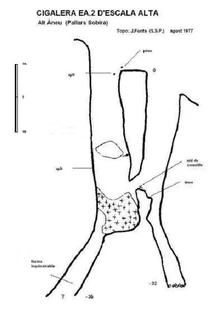
Topographic
Espeleoindex · CC BY-NC 4.0, https://creativecommons.org/licenses/by-nc/4.0/ · Image © its author.
Photos
Espeleoindex · CC BY-NC 4.0, https://creativecommons.org/licenses/by-nc/4.0/ · Image © its author.
Description
Morphology
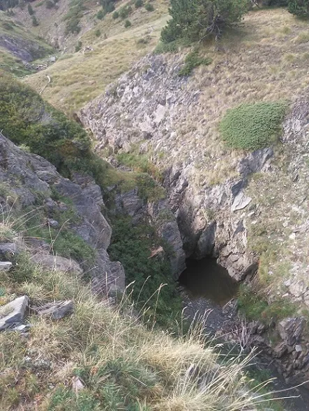
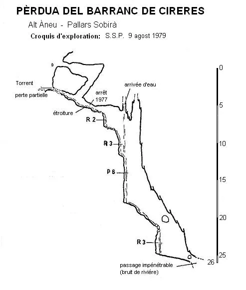
Active sinkhole passable to a depth of 26 m. Through an impassable hole on the left of the same torrent bed, the waters seep almost permanently, but 2 metres above there is a second entrance that allows access to the sinkhole.
Hydrology
Through an impassable hole on the left of the same torrent bed, the waters seep almost permanently. The members of the S.S. Plantaurel, intending to carry out as dry an exploration as possible, partially diverted the flow that entered the sinkhole and were able to verify that the important spring located in a straight line (3500 metres) and at the level of the right slope of the Noguera Pallaresa (650 metres lower down) had great variability in its flow depending on the water entering through this sinkhole.
Progression
Once on the other side of where the water enters there is a very narrow passage which, once passed, leads to a 2-metre drop followed by another of 3 and a small 6-metre pit, a short ramp and another 3-metre drop lead to the point of maximum depth where the passage becomes completely impenetrable.
History
Discovered in the summer of 1977 by members of the S.S. Plantaurel who could only enter as far as the narrow passage a few metres from the entrance due to the large quantity of water seeping through. In the summer of 1979 the flow was much lower and they were able to finish the exploration.
User Comments (0)
No comments yet.
Be the first to share your experience!
Registered Explorations (0)
No explorations registered yet.
Register your visit to this cave!
Bibliography
- Géraud, Ph. (1978).- “Reconnaissance spéléologique du massif de la Roca Blanca”. L'Echo des Tènébres (2): 4-6, S.S. Plantaurel.
- Géraud, Ph. (1979).- “Roca Blanca 1979”. L'Echo des Tènébres (5): 33-45, S.S. Plantaurel.
- Coordenades i fotografies facilitades per Ruben Rodrigo Dominguez. Actualitzat el setembre de 2024.
Nearby caves


Source: Espeleoindex (espeleoindex.com), modified. CC BY-NC 4.0, https://creativecommons.org/licenses/by-nc/4.0/