
Forat de Sobirats
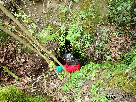
Gypsum cavity in Les Llosses, with two entrances: l'Engolidor and Forat de Sobirats, explored in 2025.
EspeleoWorld
Forat de Sobirats
Gypsum cavity in Les Llosses, with two entrances: l'Engolidor and Forat de Sobirats, explored in 2025.
Llosses, Les · Ripollès
Length: 75 m · Depth: 12 m
Updated record
https://espeleoworld.com/en/c/forat-de-sobirats
Information can change. Always verify coordinates, access, weather, and cave conditions before setting out.
Gypsum cavity in Les Llosses, with two entrances: l'Engolidor and Forat de Sobirats, explored in 2025.
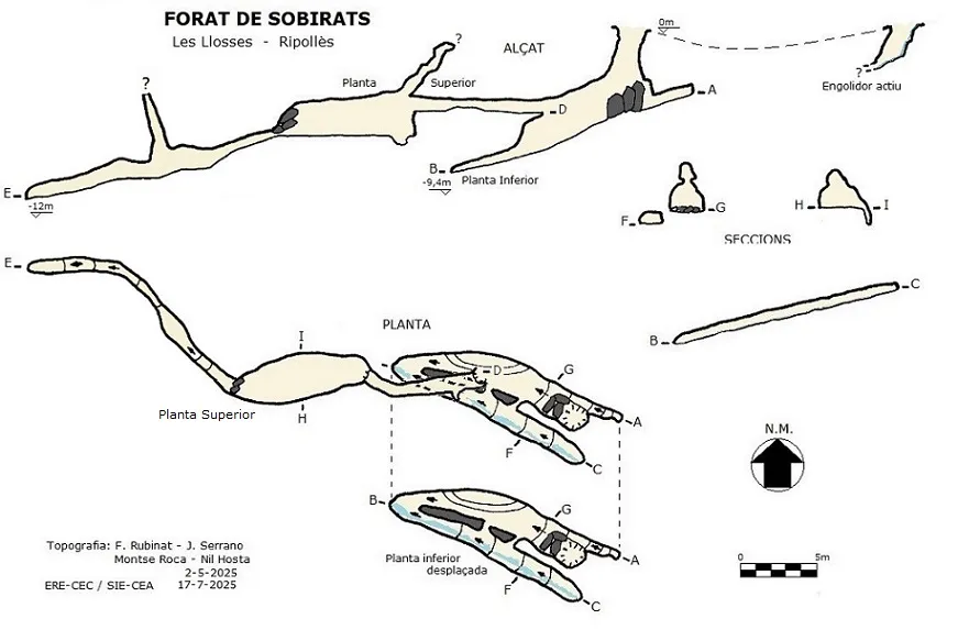
Topographic

Espeleoindex · CC BY-NC 4.0, https://creativecommons.org/licenses/by-nc/4.0/ · Image © its author.
Photos

Espeleoindex · CC BY-NC 4.0, https://creativecommons.org/licenses/by-nc/4.0/ · Image © its author.
Description
Morphology
It is a sinkhole with two entrances, formed by water coming from a spring about 40 metres further up. The water seeps through the first of the holes (l'Engolidor), but there is no physical connection with the second hole located 16 metres away (Forat de Sobirats), since at present the passage between the two holes is obstructed.
Entering through the second entrance (Forat de Sobirats) one descends a small step that places us in a descending gallery that eventually becomes impenetrable. On the left side there is a parallel gallery with a low ceiling through which a water inflow circulates.
Halfway along the gallery, at the point where there is the connection with the parallel gallery, we find an upper level that by means of a crawl of about 8 metres in length leads us to a drop of -1.7m that places us in a wide gallery 9 metres in length. At the end of this, a passage between blocks gives access to a narrow conduit about 5 metres in length descending; the gallery widens and gains height and we find a chimney more than 5 metres high. The gallery continues a few metres more with diminishing dimensions until it ends collapsed by sediments.
Hydrology
The water comes from a spring about 40 metres further up and seeps through the first of the holes (l'Engolidor). If it has rained, a stream that flows towards the lower sinkhole.
Progression
Entering through the second entrance (Forat de Sobirats) one descends a small step that places us in a descending gallery that eventually becomes impenetrable. Halfway along the gallery, at the point where there is the connection with the parallel gallery, we find an upper level that by means of a crawl of about 8 metres in length leads us to a drop of -1.7m that places us in a wide gallery 9 metres in length. At the end of this, a passage between blocks gives access to a narrow conduit about 5 metres in length descending.
History
Known since ancient times by farmers and shepherds, it is not until February of this year (2025) that it is explored by Nil Hosta Ferrer, who provides the location and accompanies Juli Serrano and Montse Roca (SIE-CEA) on a second exploration. In May of the same year they return accompanied by Francesc Rubinat (ERE-CEC); this time they bring a metal ladder to climb to the upper gallery, since the gypsum does not allow a rigging with minimum guarantees, and they take the opportunity to carry out the survey.
In July of the same year they return again to clear the final passage, advancing about fifteen metres more until it becomes impenetrable due to sediment accumulation.
User Comments (0)
No comments yet.
Be the first to share your experience!
Registered Explorations (0)
No explorations registered yet.
Register your visit to this cave!
Bibliography
Totes les dades, coordenades, situació, topografia i fotografies han estat facilitades per Nil Hosta Ferrer; Juli Serrano i Montse Roca (SIE-CEA) i Francesc Rubinat (ERE-CEC), actualització de juliol de 2025.
Nearby caves
Cova de Roquetes
2.1 km · W
Borredà (Berguedà)
1 topo.6 photos
Cova del Castell de Palmerola
2.3 km · E
Llosses, Les (Ripollès)
1 topo.8 photos
Cova de Rotgers R-1
2.5 km · W
Borredà (Berguedà)
2 topo.11 photos
Cova de R-6) R-5 R-4 R3 Rotgers (r-2
2.8 km · W
Borredà (Berguedà)
7 topo.34 photos
Source: Espeleoindex (espeleoindex.com), modified. CC BY-NC 4.0, https://creativecommons.org/licenses/by-nc/4.0/