
Forat de les Encantades del Pont d'espia
Interessant cova de 312 m. de recorregut, engolida temporalment pel pantà d'Oliana.
EspeleoWorld
Forat de les Encantades del Pont d'espia
Interessant cova de 312 m. de recorregut, engolida temporalment pel pantà d'Oliana.
Coll de Nargó · Alt Urgell
Length: 312 m · Depth: 28 m
Updated record
https://espeleoworld.com/en/c/forat-de-les-encantades-del-pont-d-espia
Information can change. Always verify coordinates, access, weather, and cave conditions before setting out.
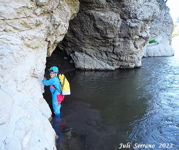
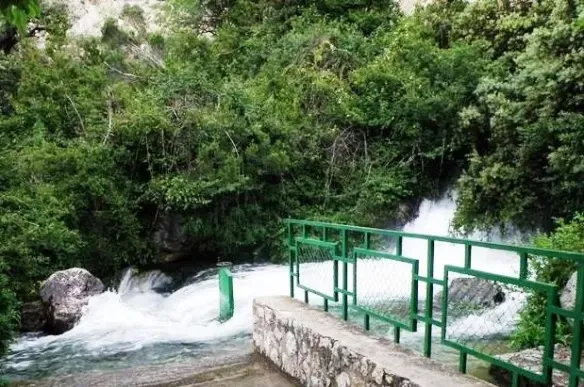
A cave with 312 m of passage, temporarily flooded by the Oliana reservoir, on the left bank of the Segre river, near the Pont d'Espia.
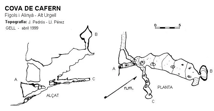
Topographic
Espeleoindex · CC BY-NC 4.0, https://creativecommons.org/licenses/by-nc/4.0/ · Image © its author.
Photos
Espeleoindex · CC BY-NC 4.0, https://creativecommons.org/licenses/by-nc/4.0/ · Image © its author.
Description
Morphology
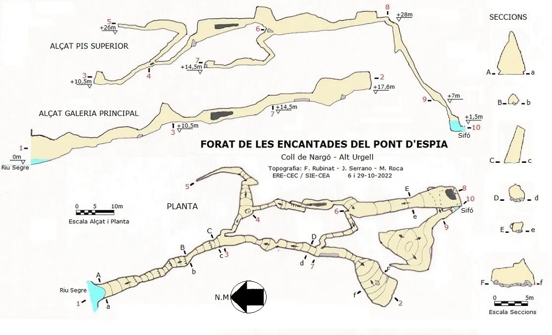
Through a wide entrance one enters the main gallery, whose floor in the first metres is covered by sediments; after a few metres the gallery narrows and begins to climb among the blocks. The sections are very varied, from narrow and high to rounded and lower-ceilinged. About 80 metres from its start the gallery opens out into a chamber 13x8 and 4 metres in average height; this chamber initially descends slightly and then climbs steeply up to the end point of the gallery (level +17m).
About 40 metres from the entrance, on the left, we find a narrow passage that gives access to some upper galleries; after the first metres we reach the foot of a muddy ascending ramp; once the ramp is climbed, at the top we find a passage of about twenty metres that heads in the direction of the Segre river, but which ends up becoming impenetrable.
Back at the base of the muddy ramp we find in its very middle an opening that gives access to a crawlway that soon becomes wider; after passing a large block in the middle of the gallery, the ceiling forms a shaft that rises about 4 metres; from its upper part a gallery of 11 metres emerges which later connects with the gallery we are following. We continue along the lower gallery until we reach a small chamber where, on the right, the upper gallery described above reaches us. Through a narrow passage of little more than one metre we reach a wide descending gallery about 3 metres wide and almost 5 metres high.
Back in the main gallery, 70 metres from the entrance and about 10 metres before reaching the final chamber, on the left we find a narrow passage that soon gains width; the gallery climbs rapidly until it emerges into the wide gallery described above, which we reached through the other passage and just below it, in the lower part of the wide gallery. The gallery continues climbing gently, with some formations found at this point; finally one reaches a chamber where, at its far end and on the left, we find a passage behind the rock that crosses it from side to side; this is the highest point of the cavity (level +28m); in the very middle of this passage the mouth of a shaft opens. To descend the shaft we will need a 30 metre rope rigged on an existing rock bridge beside the shaft and a spit at the head of the shaft. It is a muddy shaft; it begins with a slight ramp of 3.4 metres followed by a vertical drop of 6.10 metres where we land on a small ledge; the shaft continues with a steep ramp of 6.50 metres; at this point the shaft turns and continues descending in a steep ramp for 11 more metres to the base of a gallery; in total it is 21.5 metres of vertical drop. If we head NW we will enter a chamber of about 15x12 metres and 2.80 metres in height, with an important accumulation of sediments in the middle; surrounding the entire wall of the chamber we find a channel in the form of a free meander without sediments about 80 cm high. If on the contrary we head SE, we will easily descend a 3.50 metre step that will place us in a sump located at level +1.50 metres relative to the entrance. The sump is 2x0.72 metres and approximately 3 metres deep, where a passage can be seen continuing.
Speleothems
The gallery continues climbing gently, with some formations found at this point.
Hydrology
When the reservoir is at a high level, the cave remains submerged under water. The maximum impoundment level of the Oliana reservoir is 518 metres, which means that access is only possible when the reservoir level is below the 505 metre level.
The sump is 2x0.72 metres and approximately 3 metres deep, where a passage can be seen continuing.
Progression
After Coll de Nargó, along the C-14 (heading towards la Seu d'Urgell) we find on the right the well-known pont d'Espia, where the L-401 road begins, setting out on the long route to Sant Llorenç de Morunys and Port del Comte. Once past the bridge we find on the right a good place to park and only about 250 metres past the bridge we find a traffic information sign; at this point one must descend about 13 metres down the slope until reaching a small path that lies before the cliff and which we follow in the direction of the Pont d'Espia; after about 30 metres we reach a pine tree which we will use to rig a 40 metre rope that will allow us to descend to the river; the descent begins with a steep slope that soon leads us to an overhanging vertical drop of about 15 metres (a rope protector must be carried); one lands on a rock that keeps us out of the water; the cave is about 6 metres downstream and to reach it one must wade in up to the crotch because of the accumulated sediments in which we sink into the mud.
There is another access a little further on that allows one to descend to the river without equipment; then, to reach the cave one must go upstream against the current, where getting completely wet is guaranteed.
To descend the shaft we will need a 30 metre rope rigged on an existing rock bridge beside the shaft and a spit at the head of the shaft.
Other details
During the great drought suffered by Catalonia in the summer-autumn of 2022, three members of the ERE-CEC and of the SIE-CEA devoted 3 trips during the month of October to completing the exploration and survey of the whole cavity. In this period, the cave lies below the reservoir level, but currently the course of the Segre passes right along the left bank at the entrance. It could be observed that during a few hours of the day and apparently due to the daily closing of the gates of the small hydroelectric plants existing on the course of the Valira (Andorra), the Segre flows with less volume and exposes a large rock existing a few metres from the cave, which can be reached at this time by means of a rappel and accessed with practically no getting wet.
We also have evidence that adventure companies in the area run kayak excursions and, when the reservoir waters allow it, they stop at the cave and visit part of it.
History
Known since remote times by the people of the area, but despite this we know of no reference in the old catalogues or in earlier work in the area in the 1970's.
We are not very sure who made the first speleological explorations, but we have indications that they were members of the ERE – CEC (Oleguer Escolà and Montserrat Ubach) around 1967 or 1968 in one of the so-called 'extensions' of the Operació Solsonès.
As recorded in a parietal inscription inside the cavity, on 25.10.1969 it was visited by members of the U.E.U. (Unió Excursionista Urgellenca, of la Seu d'Urgell).
It is again Oleguer Escolà who, on 21.03.1971, visits the cave for the purpose of collecting fauna. As recorded in the biospeleological references, they name the cavity Cova de les Encantades del Pont d'Espia. Surely the addition of Pont d'Espia was included to distinguish it from the host of cavities recorded throughout the territory under the name Cova de les Encantades.
The following week, on 28.03.1971, members of the SIE – CEA make a new exploration; they also visit the upper gallery and make a partial survey that was never fair-copied. At that time they name the cavity Cova del Pont d'Espies (instead of d'Espia, which was the correct one). Despite an attempt two years later by the SIE, access is impossible for them because of the reservoir level; when it even seemed relatively low, for a time it was thought, erroneously, that the cave had been completely plugged by sediments.
It is not until early December 2007 that a group of speleologists from different groups (SIE; GIEG; ERE; ECG) are able to gain access to the cavity and explore it, it seems, in its entirety. (See Espeleobloc, 2-12-2007). On this occasion it is said that the raiers who went down the Segre knew the cavity as Forat de les Fades.
Almost 10 years later (September 2017), Marcel Fité, writer, linguist, pedagogue and son of Coll de Nargó, rediscovers this Espeleobloc entry and adds a comment: He says that in Nargó the cave has never been known either as Forat de les Fades or as Cova del Pont d'Espia, that it has always been called Forat de les Encantades. That in 1969 he himself took part in the visit made by the excursionists of la Seu d'Urgell, but that long before, en Pere Ramoneda, of Cal Guillot, had guided a group of speleologists. He also relates the anecdote that the painter Joaquim Mir, during his stay in Nargó, had had a photo taken at the entrance of the cave and that Mercè Rodoreda speaks of the cave in one of her novels.
Bio
Coleoptera
- Col. Leiodidae Lepthodirini Troglocharinus mercedesi (Zariquiey)
1-X-2022 9 + 1† collected by J.Serrano & M. Roca leg.
(Identification data provided by Jordi Comas)
- Troglocharinus mengeli (Jeannel, 1910) (O. Escolà, 21-3-1971)
(These two Troglocharinus had previously been classified within the genus Speonomus)
Diplura
- Plusiocampa bonneti ssp escolai (O. Escolà, 21-3-1971)
User Comments (0)
No comments yet.
Be the first to share your experience!
Registered Explorations (0)
No explorations registered yet.
Register your visit to this cave!
Bibliography
- Borràs, J.; Miñarro, J.M.; Talavera, F.(1978).- Catàleg Espeleològic de Catalunya ”Alt Urgell i la Cerdanya” (Vol.1):1-186. Ed. Políglota. Barcelona.
- Sendra, A. (1985).- “Campodeidos (Insecta: Diplura) cavernícolas de Cataluña y Huesca”. Butlletí de la Institució Catalana d'Història Natural (52): 119-128. ICHN – IEC. Barcelona.
- Valles, Jordi de (2009).-”Alt Urgell, Noguera, Pla d'Urgell, Segarra, Solsonès, Urgell”. Catàleg Espeleològic de Catalunya. (Vol. 2): 384 pp. Espeleo Club de Gràcia / Federació Catalana d'Espeleologia. Barcelona.
- Totes les dades, topografia i fotografies han estat facilitades per Juli Serrano, Montse Roca (SIE-CEA) i Francesc Rubinat (ERE-CEC) octubre de 2022.
Nearby caves


Source: Espeleoindex (espeleoindex.com), modified. CC BY-NC 4.0, https://creativecommons.org/licenses/by-nc/4.0/