
Esquerda de la Teixeta
A 12-metre-deep fissure in Margalef, accessible from one end and impenetrable at -12 metres.
EspeleoWorld
Esquerda de la Teixeta
A 12-metre-deep fissure in Margalef, accessible from one end and impenetrable at -12 metres.
Margalef · Priorat
Length: 15 m · Depth: 12 m
Updated record
https://espeleoworld.com/en/c/esquerda-de-la-teixeta
Information can change. Always verify coordinates, access, weather, and cave conditions before setting out.
A 12-metre-deep fissure in Margalef, accessible from one end and impenetrable at -12 metres.
Topographic
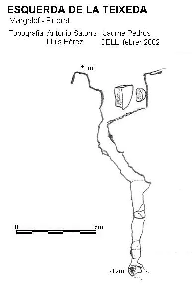
Espeleoindex · CC BY-NC 4.0, https://creativecommons.org/licenses/by-nc/4.0/ · Image © its author.
Description
Morphology
A fissure accessible from one of its ends, it descends to -12 metres where it becomes totally impenetrable.
History
The first reference we have is that of the exploration by the GELL in February 2002.
User Comments (0)
No comments yet.
Be the first to share your experience!
Registered Explorations (0)
No explorations registered yet.
Register your visit to this cave!
Bibliography
- Farrús, M.;Satorra, A.;Pérez, Ll.(1999).-”Resultats de les campanyes del grup espeleològic lleidatà a la serra del Montsant. Anys 1995-1997. El Montsant”. Grallera (5):5-44. GELL. Lleida.
- Farrús, M.;Satorra, A.;Pérez, Ll.(2006).-”Resultats de les campanyes del GELL a la serra del Montsant,II. Anys 1998-2005”. Grallera (6):3-33. GELL. Lleida.
Nearby caves


Source: Espeleoindex (espeleoindex.com), modified. CC BY-NC 4.0, https://creativecommons.org/licenses/by-nc/4.0/