
Cueva de la Primavera
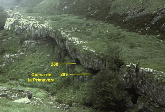
The cueva de la Primavera, in Soba, has two entrances, cavities 289 and 288, and extends to the Bibracte sump at -123.
EspeleoWorld
Cueva de la Primavera
The cueva de la Primavera, in Soba, has two entrances, cavities 289 and 288, and extends to the Bibracte sump at -123.
Soba
Length: 1367 m · Depth: 123 m
Updated record
https://espeleoworld.com/en/c/cueva-de-la-primavera-soba
Information can change. Always verify coordinates, access, weather, and cave conditions before setting out.
The cueva de la Primavera, in Soba, has two entrances, cavities 289 and 288, and extends to the Bibracte sump at -123.
Topographic
© K.A.R.S.T., SCD - Spéléo Club de Dijon (Dijon Spéléo) · CC BY-SA 3.0, https://creativecommons.org/licenses/by-sa/3.0/ · Grottocenter: Topographie Cueva de la Primavera (licence as stated in the document) · https://grottocenter.org/ui/documents/234564
Description
Morphology
The cueva 289 is a small conduit (méandre du 14 avril) whose route is somewhat delicate at the start. Downstream, the watercourse has shaped a very fine gallery; large block deposits have been re-excavated and erosion has continued with the downcutting of a small gorge. At -115, one reaches a high chamber occupied by enormous fillings; the active stream has bypassed (lac Minoir) and inactivated a large meander, and then makes a 180° change of direction relative to the upper level (río Jose-Jose). Above, a small slightly ascending gallery, the galerie des Côtelettes, leads to a zone of narrows at 680 m from the entrance (-110), from which a noticeable draught arrives.
Speleothems
Abundant speleothem deposition crowns it all.
Hydrology
The cueva 289 allows, without rope, access after about a hundred metres to a stream (río amont) coming from the impenetrable sink of the río de la Sota (about 10 L/s at low water). After one hundred metres, the river plunges into a shaft. The Bibracte sump and the flooded fissures downstream of the Côtelettes mark the current low points where the active streams appear to disappear.
Progression
The cueva 288 (méandre de la Chèvre) is the most comfortable entrance, but quickly requires rigging a P.15. From the shaft where the river plunges, the cascades follow one another rapidly (P.18, P.7, P.14, P.22, P.17); throughout this sector, floods can be formidable. After a final 6 m drop, one reaches the Bibracte sump (-123). A very severe passage (Voûte Hard de Dijon) leads a few metres further to a small tributary stream whose upstream is quickly impassable.
User Comments (0)
No comments yet.
Be the first to share your experience!
Registered Explorations (0)
No explorations registered yet.
Register your visit to this cave!
Nearby caves

Contains information from Grottocenter (Wikicaves), grottocenter.org, made available under the Open Database License (ODbL 1.0, https://opendatacommons.org/licenses/odbl/1-0/), modified. · https://grottocenter.org/ui/entrances/168645 · The derived data is available on request under the ODbL: [email protected] · data as of 2026 · Source: Grottocenter (Association Wikicaves), worldwide collaborative cave database (grottocenter.org), modified. CC BY-SA 3.0, https://creativecommons.org/licenses/by-sa/3.0/ Grottocenter (Wikicaves) · Text by KDD122 (Description), KDD122 (Accès) · adapted by Espeleoworld (normalized, translated); the adaptation is licensed CC BY-SA 3.0, https://creativecommons.org/licenses/by-sa/3.0/ · https://grottocenter.org/ui/entrances/168645 · data as of 2026 · Source: Karsteau (Fédération Française de Spéléologie et Canyon) (www.karsteau.org), modified. CC BY-NC-SA (version not stated by the source), https://www.karsteau.org/karsteau/index.php Karsteau (Fédération Française de Spéléologie et Canyon) · names · obtained 2026-11-11 · https://www.karsteau.org/karsteau/recherche/entree/recherche_entree.php?entree=21089 · data as of 2026