
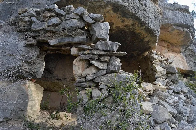
Cova del Valent
Small rock shelter in the Roca Roja area, in the Montsià, formed by a large rock overhang closed off with a dry-stone wall.
EspeleoWorld
Cova del Valent
Small rock shelter in the Roca Roja area, in the Montsià, formed by a large rock overhang closed off with a dry-stone wall.
Alcanar · Montsià
Length: 5 m
Updated record
https://espeleoworld.com/en/c/cova-del-valent
Information can change. Always verify coordinates, access, weather, and cave conditions before setting out.
Small rock shelter in the Roca Roja area, in the Montsià, formed by a large rock overhang closed off with a dry-stone wall.
Photos
Espeleoindex · CC BY-NC 4.0, https://creativecommons.org/licenses/by-nc/4.0/ · Image © its author.
Description
Morphology
It is no more than a large rock overhang that has formed a lower space which has been closed off by a dry-stone wall, which must have served as a refuge for shepherds.
No survey is available and therefore we do not know the exact dimensions of the concavity.
History
Certainly known for a long time by those with good knowledge of the Montsià.
Georeferenced on the ICGC map and on other hiking maps.
User Comments (0)
No comments yet.
Be the first to share your experience!
Registered Explorations (0)
No explorations registered yet.
Register your visit to this cave!
Bibliography
- Totes les dades i fotografies ha estat extretes del blog: senderes.blogspot (de Pep Badia, la Ràpita). Inclou ruta de wikiloc i track.
Nearby caves


Source: Espeleoindex (espeleoindex.com), modified. CC BY-NC 4.0, https://creativecommons.org/licenses/by-nc/4.0/