
Cova de les Lloberes
Cova de 150 metres de recorregut a Les Llosses
EspeleoWorld
Cova de les Lloberes
Cova de 150 metres de recorregut a Les Llosses
Llosses, Les · Ripollès
Length: 150 m · Depth: 19 m
Updated record
https://espeleoworld.com/en/c/cova-de-les-lloberes
Information can change. Always verify coordinates, access, weather, and cave conditions before setting out.
A 150-metre-long cave in Les Llosses, with a total elevation difference of 19 metres (-13/+6). First speleological exploration on 31-8-1962 by M. Ubach, C. Tarrés (EDES-CEC Bages) and J. Martínez.
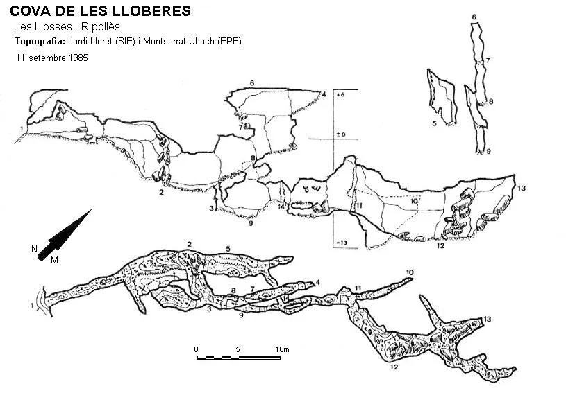
Topographic

Espeleoindex · CC BY-NC 4.0, https://creativecommons.org/licenses/by-nc/4.0/ · Image © its author.
Photos

Espeleoindex · CC BY-NC 4.0, https://creativecommons.org/licenses/by-nc/4.0/ · Image © its author.
Description
Morphology
Cave with 150 metres of passage. A short gallery, a descending ramp and a first fork. Following the right-hand branch we soon find three ways on: a chamber with no continuation, a shaft of about 3 metres and a new gallery. Along this one can ascend by opposition up to a small upper level where the highest point of the cavity is reached (+6 m above the entrance). Descending the small shaft gives access to a lower gallery where, a few metres along and on the left, a perpendicular conduit appears that leads into a chamber, the only decorated place in the cave, which connects with the left branch of the fork of the entrance ramp to the cavity. The total elevation difference is 19 metres (-13/+6).
Speleothems
The only decorated place in the cave is a chamber in the lower gallery.
Hydrology
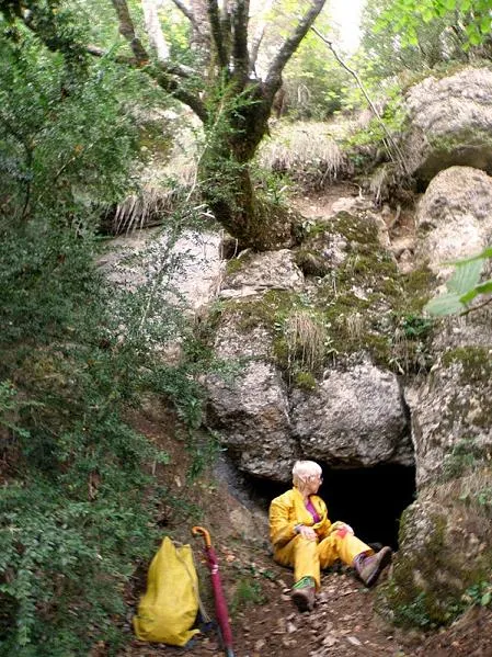
The track ends at the joncar de les Lloberes, a flat area that acts as a funnel for the waters that come down from the different torrents of the serra de Faig-i-branca. We find a first spring, and a good stretch further up a more obvious spring where there is also a water catchment. This is the font dels Cóms, near which we already find the entrance of the cave.
Progression
A short gallery, a descending ramp and a first fork. Following the right-hand branch we soon find three ways on: a chamber with no continuation, a shaft of about 3 metres and a new gallery. Along this one can ascend by opposition up to a small upper level where the highest point of the cavity is reached (+6 m above the entrance). Descending the small shaft gives access to a lower gallery where, a few metres along and on the left, a perpendicular conduit appears that leads into a chamber, the only decorated place in the cave, which connects with the left branch of the fork of the entrance ramp to the cavity.
History
Known since long ago by the locals of the area, the first speleological exploration was carried out on 31-8-1962 by M. Ubach, C. Tarrés (EDES-CEC Bages) and J. Martínez.
These, as well as later J. Lloret and M. Ubach, wrongly place it in the municipality of Sant Jaume de Frontanyà in the comarca of Berguedà. In fact it never belonged to Berguedà, since until 1991 it belonged to the municipality of Palmerola and in 1991 this municipality was annexed to the municipality of les Llosses, both of which belonged to the comarca of Ripollès.
Bio
10-XII-2016 J. Serrano-M. Roca. Col. Leiolidae Lepthodirirni Parvospeonomus delarouzeei
User Comments (0)
No comments yet.
Be the first to share your experience!
Registered Explorations (0)
No explorations registered yet.
Register your visit to this cave!
Bibliography
- Lloret, J.(SIE-CEA); Ubach, M.(ERE-CEC). (1992).-“Recull de cavitats inèdites (5). Fulls Periòdics d'Informació General (36): 18-39, FCE. Barcelona.
- Coordenades i fotografies extretes del blog “Espeleobloc”, (http://espeleobloc.blogspot.com.es/2013/10/cova-de-les-lloberes.html#comment-form) post del dia 7 d'octubre del 2013.
- Coordenades i situació aportades per la web “Engarrista” (www.engarrista.com) de Marc Solé post del dia 20 d'octubre de 2012. ”Cova de les Lloberes”.
Nearby caves
Esquerdes de Santa Eugènia
2.2 km · NE
Sant Jaume de Frontanyà (Berguedà)
1 topo.3 photos
Cova del Rec de les Muntanyetes
2.4 km · NE
Pobla de Lillet, La (Berguedà)
1 topo.7 photos
Bauma del Salt del Bisbe
2.8 km · N
Pobla de Lillet, La (Berguedà)
2 topo.2 photos
Cova de Roquetes
3.8 km · S
Borredà (Berguedà)
1 topo.6 photos
Source: Espeleoindex (espeleoindex.com), modified. CC BY-NC 4.0, https://creativecommons.org/licenses/by-nc/4.0/