

Cova de les Escales de la Gloria
Small travertine cave in the Glorieta river valley, between Mont-ral and Alcover, with a short gallery of 7.75 metres and a vertical drop of +1 metre.
EspeleoWorld
Cova de les Escales de la Gloria
Small travertine cave in the Glorieta river valley, between Mont-ral and Alcover, with a short gallery of 7.75 metres and a vertical drop of +1 metre.
Mont-ral · Alt Camp
Length: 8 m · Depth: 1 m
Updated record
https://espeleoworld.com/en/c/cova-de-les-escales-de-la-gloria
Information can change. Always verify coordinates, access, weather, and cave conditions before setting out.
Small travertine cave in the Glorieta river valley, between Mont-ral and Alcover, with a short gallery of 7.75 metres and a vertical drop of +1 metre.
Topographic
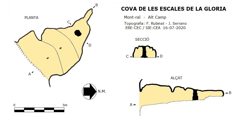

Espeleoindex · CC BY-NC 4.0, https://creativecommons.org/licenses/by-nc/4.0/ · Image © its author.
Photos

Espeleoindex · CC BY-NC 4.0, https://creativecommons.org/licenses/by-nc/4.0/ · Image © its author.
Description
Morphology
A wide entrance open in the cliff and formed by travertines gives access to a short, slightly ascending gallery. This small cave has a route of 7.75 metres and a vertical drop of +1 metre.
Speleothems
In the final stretch of the gallery there is a stalagmitic column; behind it the passage becomes narrower and closes.
History
Cavity explored by the SIEP in 1979; they named it Bauma del Salt del Niu del Aguila. This name is considered completely erroneous, since the Salt del Niu de l'Àliga, quite well known, is located more than 500 metres downstream, specifically at the height of the old power station. The cavity is in fact located at the beginning of the area known as les Escales de la Gloria; indeed, canyoners know this place as the amphitheatre, and the cave is above the vertical of the passage of the Túnel de Toba. This toponym error with respect to the real location of the place has led to not a few unsuccessful searches; for this reason it is thought more logical to cite it with the more appropriate name of Escales de la Gloria, which is the place where it is actually located.
User Comments (0)
No comments yet.
Be the first to share your experience!
Registered Explorations (0)
No explorations registered yet.
Register your visit to this cave!
Bibliography
- Cabeza, J.(1980).-”Bauma del Salt del Niu del Aguila, Cova Calavera”. Bol. Esp. SIEP (12):30-33. SIEP-CE Poblet. Barcelona.
- Dades, situació, coordenades, topografia i fotografies, aportades per Juli Serrano (SIE-CEA) i Francesc Rubinat (ERE-CEC).
Nearby caves

Cova de la Calavera
0.0 km · E
Mont-ral (Alt Camp)
2 topo.13 photos

Cova Alta de les Escales de la Gloria
0.0 km · N
Mont-ral (Alt Camp)
1 topo.5 photos

Cova de les Tosques del Glorieta
0.1 km · NE
Mont-ral (Alt Camp)
1 topo.4 photos

Avenc Musté Recasens
1.4 km · NW
Mont-ral (Alt Camp)
2 topo.5 photos
Source: Espeleoindex (espeleoindex.com), modified. CC BY-NC 4.0, https://creativecommons.org/licenses/by-nc/4.0/