
Avenc del Misteri
A 26 m deep fissure in the Muntanyes de Prades, discovered and explored by GIEM – CE Montblanc on 19 November 1994.
EspeleoWorld
Avenc del Misteri
A 26 m deep fissure in the Muntanyes de Prades, discovered and explored by GIEM – CE Montblanc on 19 November 1994.
Montblanc · Conca de Barberà
Length: 96 m · Depth: 26 m
Updated record
https://espeleoworld.com/en/c/avenc-del-misteri
Information can change. Always verify coordinates, access, weather, and cave conditions before setting out.
A 26 m deep fissure in the Muntanyes de Prades, discovered and explored by GIEM – CE Montblanc on 19 November 1994.
Topographic
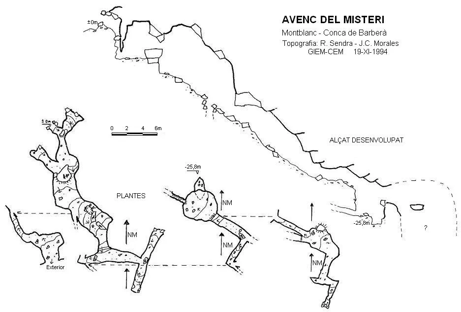
Espeleoindex · CC BY-NC 4.0, https://creativecommons.org/licenses/by-nc/4.0/ · Image © its author.
Description
Morphology
Fissure 26 m deep. Via a step between blocks one enters a chaotic gallery, occupied in large part by blocks. Once the largest ones have been passed by means of a short step, the gallery takes a markedly descending direction and shortly after it begins there is an exit to the outside. At the end of the ramp and having passed a new step of about 4 metres one reaches the point of maximum depth (elevation – 25.8). Above it, the fissure continues but its passage is impracticable.
Progression
Via a step between blocks one enters a chaotic gallery. Once the largest blocks have been passed by means of a short step, the gallery takes a markedly descending direction. At the end of the ramp and having passed a new step of about 4 metres one reaches the point of maximum depth (elevation – 25.8).
History
Discovered and explored by members of GIEM – CE Montblanc on 19 November 1994.
User Comments (0)
No comments yet.
Be the first to share your experience!
Registered Explorations (0)
No explorations registered yet.
Register your visit to this cave!
Bibliography
- Totes les dades i topografia van ser aportades per Ramon Sendra (GIEM) l'any 1994.
Nearby caves




Source: Espeleoindex (espeleoindex.com), modified. CC BY-NC 4.0, https://creativecommons.org/licenses/by-nc/4.0/