
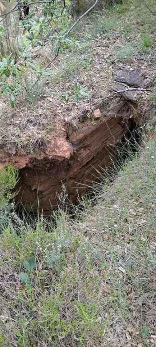
Avenc de Sant Martí
Petit avenc de 10 m de fondària a la vall del riu de Sallent (Coll de Nargó)
EspeleoWorld
Avenc de Sant Martí
Petit avenc de 10 m de fondària a la vall del riu de Sallent (Coll de Nargó)
Coll de Nargó · Alt Urgell
Length: 20 m · Depth: 10 m
Updated record
https://espeleoworld.com/en/c/avenc-de-sant-marti
Information can change. Always verify coordinates, access, weather, and cave conditions before setting out.
Small 10 m deep pit in the valley of the Sallent river (Coll de Nargó), discovered by herders and catalogued in June 2024.
Topographic
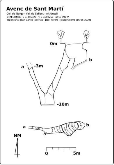

Espeleoindex · CC BY-NC 4.0, https://creativecommons.org/licenses/by-nc/4.0/ · Image © its author.
Photos

Espeleoindex · CC BY-NC 4.0, https://creativecommons.org/licenses/by-nc/4.0/ · Image © its author.
Description
Morphology
The cavity originates in a depression formed by collapse and with the walls covered by a good thickness of mud. Shortly after starting the descent, a powerful mud plug divides the vertical into two; on one side it closes a couple of metres further down and on the other a semi-vertical conduit originates, of reduced dimensions and in the form of a pressure tube, which descends to a depth of 10 m. Here the cavity closes, although in a corner there is a chimney of subvertical layout that rises some 7 m until some roots are observed, which suggests that it ends near the surface.
History
The cavity had been discovered by herders of the area, since there is a fence encircling the entrance to prevent livestock from falling in, but we do not know the date and it had not become known to the speleological world. It is not until June 2024 that it was located with the help of the Lidar map by Josep Guarro, Joan Carles Juderias and Jordi Perera on 2 June. They themselves return on 16-6-2024 carrying out the exploration and take the data for its cataloguing.
User Comments (0)
No comments yet.
Be the first to share your experience!
Registered Explorations (0)
No explorations registered yet.
Register your visit to this cave!
Bibliography
- Totes les dades, topografia i fotografies han estat extretes del web: espeleodijous.cat Apunt de l'activitat del 16-6-2024
Nearby caves
Avenc del Cataplanell
3.4 km · W
Coll de Nargó (Alt Urgell)
1 topo.11 photos
Pou de la Serreta
3.8 km · N
Coll de Nargó (Alt Urgell)
1 topo.8 photos
Avenc d'en Barceló
4.4 km · SW
Coll de Nargó (Alt Urgell)
1 topo.1 photos
Forat Petit de Prat Sobirà
4.5 km · W
Coll de Nargó (Alt Urgell)
2 topo.8 photos
Source: Espeleoindex (espeleoindex.com), modified. CC BY-NC 4.0, https://creativecommons.org/licenses/by-nc/4.0/