
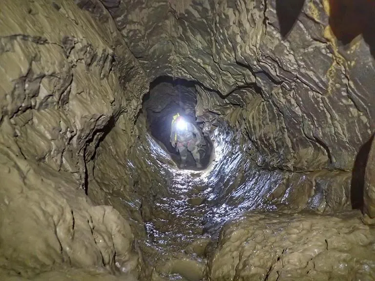
Antic Bullidor
Interessant avenc de 188 metres de fondària variable, situat a Gisclareny.
EspeleoWorld
Antic Bullidor
Interessant avenc de 188 metres de fondària variable, situat a Gisclareny.
Gisclareny · Berguedà
Length: 398 m · Depth: 188 m
Updated record
https://espeleoworld.com/en/c/antic-bullidor
Information can change. Always verify coordinates, access, weather, and cave conditions before setting out.
A pit of 188 metres of variable depth in Gisclareny, discovered in 1989 by SIES – CCR l'Avenç, with explorations down to the -188 metres level in 2016.
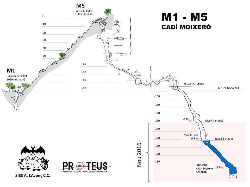
Topographic
Espeleoindex · CC BY-NC 4.0, https://creativecommons.org/licenses/by-nc/4.0/ · Image © its author.
Photos
Espeleoindex · CC BY-NC 4.0, https://creativecommons.org/licenses/by-nc/4.0/ · Image © its author.
Description
Morphology
The cavity is structured along a joint that on the outside is about 5 metres long; at one of its ends is the point where the last digging was carried out, which gives access to the interior through a narrow passage that increases in size as we descend. A first 4-metre drop places us on a ledge where we find some debris from the outside. From this point we are on the vertical; an aerial section places us on a new ledge. At the end of the gallery we find two new drops of 5 and 6 metres respectively that give access to a room of considerable dimensions. Further on there is an 11-metre-deep pit and, at the other end, a steeply sloping gallery that ends in a 7-metre pit, which places us at -130 metres depth. The pit continues descending until reaching the -153 metres level, where the current water level is (3-9-2016); here begins a submerged and quite steep gallery that places us at the -188 metres level, where the head of a new pit that continues descending can be seen.
Speleothems
In a descending gallery we find some formations and the floor covered with small concreted gours.
Hydrology
After a short distance we reach the first permanent sump, about 3 metres long, which forces us to do a small apnea. In rainy periods the area of a low-roofed gallery full of mud remains flooded. At the -153 metres level is the current water level (3-9-2016). The exploration of the cavity is conditioned by the water level, which is highly variable over short periods of time, and taking into account the degree of danger depending on the weather conditions.
Progression
Once past the narrow access passage, a first 4-metre drop places us on a ledge. From here, a re-rigging allows us to traverse to the other end, seeking the widest part. From this point we are on the vertical; an aerial section places us on a new ledge, to the left of which there is the option of continuing to descend down a steep slope, at the base of which and after overcoming a couple of drops a descending gallery begins. At the end of the gallery we find two new drops of 5 and 6 metres respectively that give access to a room of considerable dimensions. At the other end we find a new low-roofed gallery full of mud. After a short distance we reach the first permanent sump, about 3 metres long, which forces us to do a small apnea. From this point the gallery climbs steeply for a few metres until it becomes horizontal; at the end of this section we find two continuations, one at the base of the gallery, where there is an impassable passage that communicates again with the gallery at a lower point, and the other at the upper part, where a drop must be overcome; once past this, the gallery descends in slope until it reaches an 11-metre-deep pit. At its base we find a chimney that communicates with the impassable passage indicated above; at the other end begins a steeply sloping gallery that ends in a 7-metre pit, which places us at -130 metres depth, the point where the maximum level of access achieved on 7 September 1993 was reached. From the end of that exploration, the pit continues descending until reaching the -153 metres level, where we find the current water level (3-9-2016); here begins a submerged and quite steep gallery that places us at the -188 metres level, where the head of a new pit that continues descending can be seen.
History
Discovered in 1989 by members of SIES – CCR l'Avenç (Esplugues de Llobregat) after carrying out a major digging at the entrance mouth. That same year they manage to reach the -77 level, where a flooded pit prevents their progress. The following year (1990) explorations continue and, due to the low water, they manage to reach 110 metres depth (survey at -82). It is not until 1993 and, after numerous attempts, that on 9 September they manage to reach the point of maximum depth (-130 metres). It is not until 3 September 2016, when members of SIES-l'Avenç together with Hilari Moreno (Associació Catalana d'Espeleologia Subaquàtica-PROTEUS) manage to reach the -153 metres level, the point where they find the current water level due to this year's drought. From this point they carry out a dive of -35 metres depth, reaching the -188 metres level at the head of what appears to be a new pit.
User Comments (0)
No comments yet.
Be the first to share your experience!
Registered Explorations (0)
No explorations registered yet.
Register your visit to this cave!
Bibliography
- Subirada, Ramon (1992).- “Antic Bullidor (M-5)”. Espeleología SIES (1): 37-39. SIES-CCR l'Avenç. Esplugues de Llobregat.
- Asensio Vela, Antonio.(1997).-”Exploracions a la Serra del Cadí.(Recull preliminar dels treballs efectuats de 1982 a 1992”. Cavernes (24):61-64. GE Badalona.
- SIES (1990).-Memoria Campaña 1990. SIES – CCR l'Avenç. Esplugues de Llobregat (inèdita).
- SIES (1993).-Memoria Campaña 1993. SIES – CCR l'Avenç. Esplugues de Llobregat (inèdita).
- Dades, topografia i fotos extretes del Facebook de la SIES-l'Avenç d'Esplugues de Llobregat. Nota del 7 de setembre de 2016.
- Coordenades i foto boca facilitades l'agost de 2019 per Josep Guarro.
Nearby caves


Source: Espeleoindex (espeleoindex.com), modified. CC BY-NC 4.0, https://creativecommons.org/licenses/by-nc/4.0/