
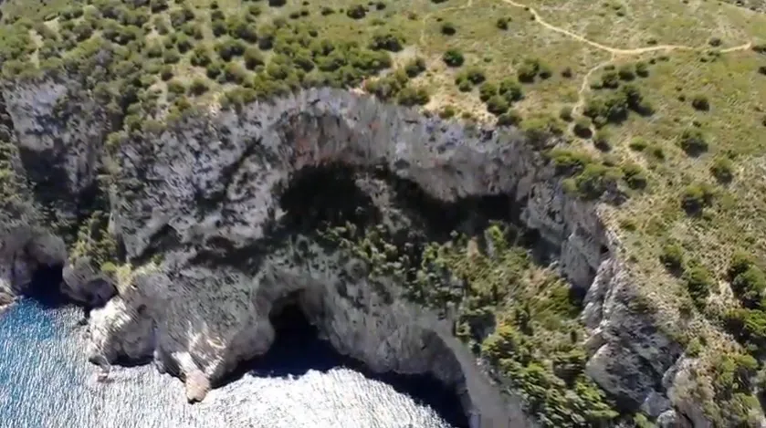
Pou d'en Narcís
A 70 m deep pit on the coast of l'Estartit (Baix Empordà), discovered by Narcís Arbusé and explored and surveyed by SIE – CEA at the end of 2006.
EspeleoWorld
Pou d'en Narcís
A 70 m deep pit on the coast of l'Estartit (Baix Empordà), discovered by Narcís Arbusé and explored and surveyed by SIE – CEA at the end of 2006.
Torroella de Montgrí · Baix Empordà
Sviluppo: 96 m · Profondità: 70 m
Scheda aggiornata
https://espeleoworld.com/it/c/pou-d-en-narcis
Le informazioni possono cambiare. Verifica sempre coordinate, accesso, meteo e condizioni della cavità prima di partire.
A 70 m deep pit on the coast of l'Estartit (Baix Empordà), discovered by Narcís Arbusé and explored and surveyed by SIE – CEA at the end of 2006.
Topografia
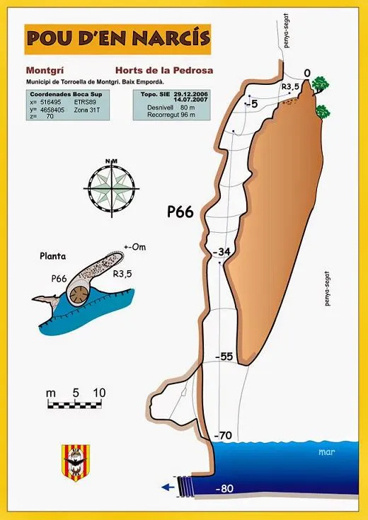

Espeleoindex · CC BY-NC 4.0, https://creativecommons.org/licenses/by-nc/4.0/ · Immagine © del suo autore.
Foto

Espeleoindex · CC BY-NC 4.0, https://creativecommons.org/licenses/by-nc/4.0/ · Immagine © del suo autore.
Descrizione
Morfologia
A first down-climbable step of 3.5 metres places us on a ramp 10 metres long, at the end of which is already the cylindrical pit of 66 metres. At level -55 the pit bursts open into a large portal of the cingle and plunges to sea level at level -70.
Ten metres below sea level a platform develops with a hollow that falsely appeared to lead to a submarine gallery; by penduling, or from sea level, one can access a small lateral concavity 3 metres above sea level.
Progressione
It should be noted that as of May 2021 all the fixed riggings in the cavity are unusable due to corrosion; using them represents a mortal danger. It should also be borne in mind that the friction of the rope against the walls causes a continuous fall of small stones and, when you least expect it, some large ones.
Storia
Cavity discovered by Narcís Arbusé, a great connoisseur of the Montgrí, we believe at the beginning of the 2000s. With different companions they explored the cavity (we do not know whether totally or partially), as recorded in his book El Montgrí pas a pas. But it is not until the end of 2006 that they accompany members of the SIE – CEA, who carry out a total exploration and the survey, thus making it known.
Commenti degli utenti (0)
Nessun commento ancora.
Sii il primo a condividere la tua esperienza!
Esplorazioni registrate (0)
Nessuna esplorazione registrata.
Registra la tua visita a questa grotta!
Bibliografia
- Arbusé Bellapart, Narcís (2005).-El Montgrí pas a pas. 174 pp. Cossetània Edicions. Valls.
- Valles, Jordi de (2010).-”Alt Empordà, Baix Empordà, Gironès, Osona, Pla de l'Estany, Selva”. Catàleg Espeleològic de Catalunya. (Volum 4):1-397. Espeleo Club de Gràcia / Federació Catalana d'Espeleologia. Barcelona.
- Dades extretes del blog: espeleobloc.blogspot.com (apunt del 14-7-2013).
- Coordenades i actualització de dades, facilitades per Jordi Boix i Sònia Rivarola.
- Actualització de dades el maig de 2021, fotografia aèria i de la situació de la boca de Juan Carmelo Blanco; fotografia de la boca de Juli Serrano; fotografia des de l'interior de la Foradada de Roger Rovira; la resta de fotografies han estat extretes del muntatge de video de Salvador Lapeña https://youtu.be/9kGuEG1-mzk
Grotte vicine

Bauma d'en Narcís
0.0 km · NE
Torroella de Montgrí (Baix Empordà)
1 foto
Cau dels Horts de la Pedrosa
0.1 km · E
Torroella de Montgrí (Baix Empordà)
4 topo.8 foto
Cova de l'Aigua
0.3 km · SE
Torroella de Montgrí (Baix Empordà)

Avenc Petit del Solei de la Pedrosa
0.3 km · S
Torroella de Montgrí (Baix Empordà)
1 topo.5 foto
Fonte: Espeleoindex (espeleoindex.com), modificato. CC BY-NC 4.0, https://creativecommons.org/licenses/by-nc/4.0/