
l'Avencó de Bigues
A 15 m long spring in Bigues i Riells (Vallès Oriental), an active cave with 9 m traversed by water, and other related hydrological phenomena: Les Barbotes and l'Avencó d'Aiguafreda.
EspeleoWorld
l'Avencó de Bigues
A 15 m long spring in Bigues i Riells (Vallès Oriental), an active cave with 9 m traversed by water, and other related hydrological phenomena: Les Barbotes and l'Avencó d'Aiguafreda.
Bigues i Riells · Vallès Oriental
Sviluppo: 15 m
Scheda aggiornata
https://espeleoworld.com/it/c/l-avenco-de-bigues
Le informazioni possono cambiare. Verifica sempre coordinate, accesso, meteo e condizioni della cavità prima di partire.
A 15 m long spring in Bigues i Riells (Vallès Oriental), an active cave with 9 m traversed by water, and other related hydrological phenomena: Les Barbotes and l'Avencó d'Aiguafreda.
Topografia

Espeleoindex · CC BY-NC 4.0, https://creativecommons.org/licenses/by-nc/4.0/ · Immagine © del suo autore.
Foto

Espeleoindex · CC BY-NC 4.0, https://creativecommons.org/licenses/by-nc/4.0/ · Immagine © del suo autore.
Descrizione
Morfologia
The morphology of the cavity shows evident erosion forms, with remains of forced-circulation conduits.
Idrologia
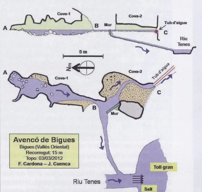
It is an active cave. The water seems to come from impenetrable cracks. The water that comes out goes to meet the Tenes, but, before that, a small weir diverts part of the flow towards a second small cave that crosses a rock face; on the other side, the water is channelled, probably to irrigate neighbouring vegetable gardens.
Les Barbotes: In this spring the water gushes out under ascending pressure through several impenetrable holes, creating a small muddy marsh. The flows join and immediately afterwards are added to that contributed by the Tenes. One might think that Les Barbotes could act as a “trop plein” of l'Avencó de Bigues, but all the data and observations made suggest that these are two totally independent phenomena.
L'Avencó d'Aiguafreda: At present there is no visible sinkhole, but if the flow of the stream is not very large, we will observe that it gradually diminishes along a stretch of stream until it disappears completely, so that water will no longer reach the nearby confluence with the Congost. Data are known from N. Llopis Lladó that in the 1940s there was a sinkhole in a fault in the contact zone of the Muschelkalk limestones and the Palaeozoic slates, indicating that a cavity 5 metres long was generated. There seems to be a direct relationship between the waters swallowed in the area of l'Avencó d'Aiguafreda and those that emerge through l'Avencó de Bigues, although no dye tracing has been carried out to demonstrate this categorically.
Progressione
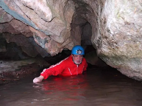
It is an active cave that can be traversed along 9 metres. That said, we will have to get wet up to the waist.
Storia
All the related hydrological phenomena have been known since time immemorial. Cited by Pascual Madoz (1845) in his “Diccionario geográfico-estadístico-histórico y sus posesiones de Ultramar”, which already hints at a hydrological relationship between them. But the first to show an interest is Mn. Font i Sagué, who visited the area on 26 July 1897, invited by the Maspons i Labrós family to Bigues, and of which he produced an interesting work.
Despite their being known, they had never been a topic of interest for speleologists given the meagre or almost non-existent speleometry of the underground conduits. It is not until 2012 that, directed by Ferran Cardona, an exhaustive and well-documented work on these hydrological phenomena is produced, which we recommend consulting in Exploracions no. 20 (2012).
Commenti degli utenti (0)
Nessun commento ancora.
Sii il primo a condividere la tua esperienza!
Esplorazioni registrate (0)
Nessuna esplorazione registrata.
Registra la tua visita a questa grotta!
Bibliografia
- Borràs, J.; Miñarro, JM.; Talavera, F. (1980).- Catàleg Espeleològic de Catalunya (vol. 6): el Baix Empordà, el Gironès, la Selva, l’Osona, el Vallès Oriental i el Maresme: 290 pp. Ed. Políglota. Barcelona.
- Cardona, Ferran; Arriba, Àngel de; Cuenca, Josep (2012).- “De l'Avencó d'Aiguafreda a l'Avencó de Bigues. Més de deu quilòmetres de curs subterrani”. Exploracions (20): 63-73. Espeleo Club de Gràcia. Barcelona.
- Font i Sagué, Norbert (1897).- “Catàlech Espeleològich de Catalunya” Butlletí CEC (24-25-26-27-29-31-32-33-35). Centre Excursionista de Catalunya. Barcelona.
- Font i Sagué, Norbert (1898).- “Excursió espeleològica a la Bancó, les Barbotes i Singles de Bertí”. Butlletí CEC (41-42-43). Centre Excursionista de Catalunya. Barcelona.
Grotte vicine

Forat de la Baga de Can Torrela
0.9 km · NE
Bigues i Riells (Vallès Oriental)
1 topo.5 foto

Balma del Ca
2.8 km · O
Sant Feliu de Codines (Vallès Oriental)
2 topo.2 foto

Barbot Petit
2.9 km · N
Sant Quirze Safaja (Moianès)
2 topo.1 foto
Cova de Vallderrós
2.9 km · N
Sant Quirze Safaja (Moianès)
2 topo.4 foto
Fonte: Espeleoindex (espeleoindex.com), modificato. CC BY-NC 4.0, https://creativecommons.org/licenses/by-nc/4.0/