
Cova d'en Gispert
The most emblematic sea cave on the Costa Brava, with a passage of 174 m, known since time immemorial and explored speleologically in 1952.
EspeleoWorld
Cova d'en Gispert
The most emblematic sea cave on the Costa Brava, with a passage of 174 m, known since time immemorial and explored speleologically in 1952.
Begur · Baix Empordà
Sviluppo: 174 m
Scheda aggiornata
https://espeleoworld.com/it/c/cova-d-en-gispert
Le informazioni possono cambiare. Verifica sempre coordinate, accesso, meteo e condizioni della cavità prima di partire.
The most emblematic sea cave on the Costa Brava, with a passage of 174 m, known since time immemorial and explored speleologically in 1952.
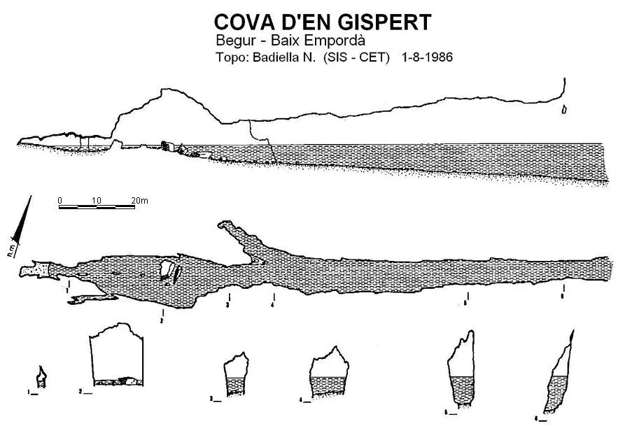
Topografia
Espeleoindex · CC BY-NC 4.0, https://creativecommons.org/licenses/by-nc/4.0/ · Immagine © del suo autore.
Foto
Espeleoindex · CC BY-NC 4.0, https://creativecommons.org/licenses/by-nc/4.0/ · Immagine © del suo autore.
Descrizione
Morfologia
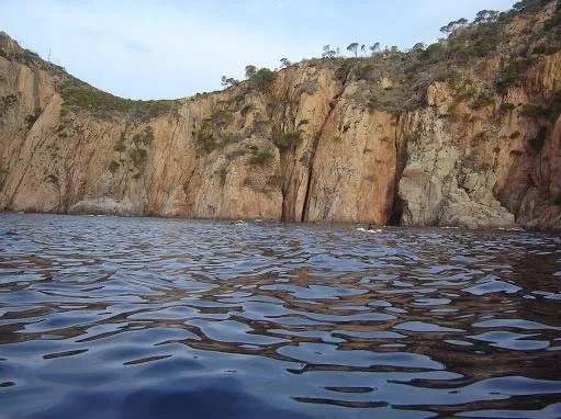
The mouth is 5 metres wide by 8 high and has a maximum water depth of 9 metres, which will slowly decrease as we go deeper into the cavity. Once through the mouth we find a long rectilinear gallery of 100 metres that widens gently to 10 metres at some point. The ceiling rises suddenly to 13 metres and then decreases towards the end of the gallery, giving way to a large hall. At 80 metres along the route we find, on the right, a gallery of 16 metres with a low ceiling and a width of 4 metres at the beginning and 2 at the end.
Returning to the main gallery we reach the aforementioned hall; this measures 32 metres long by 13 wide and 15 high. In the middle of the hall there are large blocks fallen from the ceiling that interrupt the passage of boats of regular dimensions; from here on it is only possible to continue with the help of a smaller boat or by getting wet. The water depth in the hall is shallow, from 0.20 to 1 metre at some points.
On the S side there is a gallery of 10 metres in length, quite narrow, which ends in a widening where we find two small beaches. Following the main direction of the cave, the hall suddenly loses height until reaching 1.5 metres above the water, at the same time narrowing to form a gallery with a heavily concretioned ceiling. Then one arrives at a small room where there is a pebble beach that brings the cavity to an end.
Idrologia
The maximum water depth at the mouth is 9 metres and it slowly decreases as we go deeper into the cavity. The water depth in the hall is shallow, from 0.20 to 1 metre at some points.
Progressione
In the middle of the hall there are large blocks fallen from the ceiling that interrupt the passage of boats of regular dimensions; from here on it is only possible to continue with the help of a smaller boat or by getting wet.
Storia
Known since time immemorial. The oldest account we know is that of the report of a visit published in the Eco Bisbalense (1886). It is later collected in the old catalogues (Puig y Larraz; Font i Sagué; Faura i Sans) but with practically no data about it.
The first speleological document about it does not arrive until the year 1952, the result of an exploration and study carried out by members of the GES – CMB in August of that same year.
Commenti degli utenti (0)
Nessun commento ancora.
Sii il primo a condividere la tua esperienza!
Esplorazioni registrate (0)
Nessuna esplorazione registrata.
Registra la tua visita a questa grotta!
Bibliografia
- Badiella, X. (1990).- “Cavitats litorals” a: Grans cavitats de Catalunya vol.2 de Ferran Cardona. Espeleo Club de Gràcia.
- Badiella, Enric; Badiella, Xavier; Badiella, E. (1992).- “Les cavitats litorals del Baix Empordà. (I) de Palamós a Aiguablava” SIS (12): 26-51 / Arxiu del Centre Excursionista de Terrassa (75): 162-187. Terrassa.
- Montoriol, J. (1952).- “Estudio de una cueva de erosión marina en la Costa Brava (Begur)”. Speleon III (3-4): 191-196. Universidad de Oviedo.
- Coordenades i fotos exteriors extretes de wikiloc (autor: Davecr)
- Foto interior de Josep Castelló (Canal 324)
Grotte vicine



Fonte: Espeleoindex (espeleoindex.com), modificato. CC BY-NC 4.0, https://creativecommons.org/licenses/by-nc/4.0/