

Baumes de la Molera d'ausió
A set of crevices and passages between large blocks in Sant Julià de Vilatorta (Osona), known as Les Baumes, with underground sections and remains of a molera documented in 1362.
EspeleoWorld
Baumes de la Molera d'ausió
A set of crevices and passages between large blocks in Sant Julià de Vilatorta (Osona), known as Les Baumes, with underground sections and remains of a molera documented in 1362.
Sant Julià de Vilatorta · Osona
Sviluppo: 270 m
Scheda aggiornata
https://espeleoworld.com/it/c/baumes-de-la-molera-d-ausio
Le informazioni possono cambiare. Verifica sempre coordinate, accesso, meteo e condizioni della cavità prima di partire.
A set of crevices and passages between large blocks in Sant Julià de Vilatorta (Osona), known as Les Baumes, with underground sections and remains of a molera documented in 1362.
Topografia


Espeleoindex · CC BY-NC 4.0, https://creativecommons.org/licenses/by-nc/4.0/ · Immagine © del suo autore.
Foto

Espeleoindex · CC BY-NC 4.0, https://creativecommons.org/licenses/by-nc/4.0/ · Immagine © del suo autore.
Descrizione
Morfologia
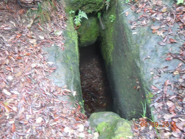
Although they have popularly been called “baumes”, it is a complex formed by crevices and a chaotic accumulation of large blocks that come to form passages between them, including important underground sections and even a small shaft.
The complex develops along a front 240 m long, but the speleologically most important part is concentrated at the western side. To the south the complex is bounded by a more or less continuous wall, though of variable height, being higher in the central part while diminishing towards the ends. From the wall towards the north a series of large blocks break away with a chaotic distribution. Between them crevices and more or less labyrinthine passages are formed. Open-air sections alternate with underground ones, the latter reaching a good total speleometry.
Given the chaotic character of the place, the topographic representation is not easy. For this reason the topography presented here must be understood as a document drawn up more to give an idea of the whole than to seek a precision difficult to obtain and represent. For the same reason, it is not easy to assign a precise speleometry to the complex, but we believe that a good approximation would be to establish it at 270 m for the whole of the crevices and passages between blocks, of which 100 m correspond to underground sections.
Altri dettagli
In general, it is an enchanting and magical place located in a slight shady spot in the middle of the forest where the moss gives a green and gloomy appearance to the whole complex. Despite being a completely natural place, it has been slightly modified by the action of the molers, whose imprint we can observe both in open-air and underground sections.
Storia
Because of its location away from places of passage, the place was known only to relatively few people of the area, who called it by the generic word “Les Baumes” despite it being crevices and passages between large blocks. It is said that during the Civil War some fugitives hid there.
This place, completely natural, has been partially modified by anthropic action, scraping and hollowing out the rock for the manufacture of millstones. Despite the centuries that have passed (probably the molera was abandoned in the 15th century), it is still easy to recognise the scars of the escodes and other tools of the miller's trade, scars that we even find in underground sections of “les Baumes”.
Thus, the historian and geographer Francesc Roma, carrying out research work in old documents dealing with the obtaining and origin of the millstones used in the flour mills of the region, became aware of the existence of a molera called d'Ausió, documented from the year 1362, which should be located around the town of Sant Julià de Vilatorta. Without knowing its precise location, in 2018 he began a task of research and prospecting throughout the municipality until he found the place that some called “Les Baumes”. He soon confirmed the existence of abandoned or half-built millstones, as well as the scars left on the rock by the millers' tools. There was no doubt, he had located the molera d’Ausió. The results of his research were published in issue 93 of the magazine Vilatorta, year 2022.
During January 2024, members of the Espeleo Club Muntanyenc Barcelonès and of the Grup d'Espeleologia de Badalona visited the place in order to obtain data from the speleological point of view.
Commenti degli utenti (0)
Nessun commento ancora.
Sii il primo a condividere la tua esperienza!
Esplorazioni registrate (0)
Nessuna esplorazione registrata.
Registra la tua visita a questa grotta!
Bibliografia
- Totes les dades, topografia i fotografies han estat extretes del web: geb.cat (del Grup d'Espeleleologia de Badalona). Apunt del 26-2-2024. Dades: Ferran Cardona (ECM Barcelonès), Josep Cuenca i Xavier Samarra (GE Badalona)
Grotte vicine

Cova del Gegant
2.4 km · SO
Sant Julià de Vilatorta (Osona)
1 topo.9 foto
Cova de Sant Miquel
2.5 km · SO
Sant Julià de Vilatorta (Osona)
2 topo.9 foto

Cova del Clos
2.5 km · SO
Sant Julià de Vilatorta (Osona)
1 topo.2 foto

Avenc d'en Casadevall
2.5 km · SO
Sant Julià de Vilatorta (Osona)
1 topo.4 foto
Fonte: Espeleoindex (espeleoindex.com), modificato. CC BY-NC 4.0, https://creativecommons.org/licenses/by-nc/4.0/