
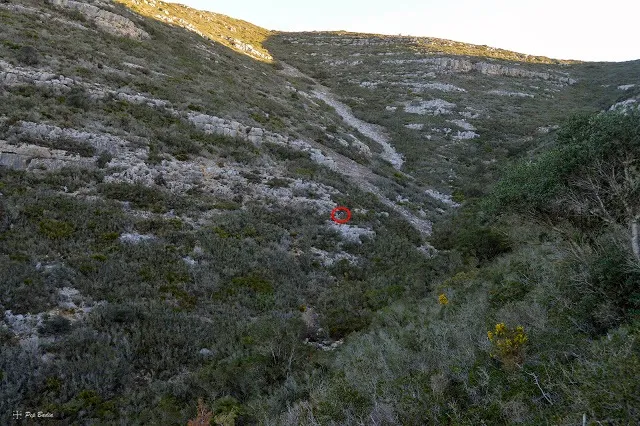
Avenc de Julio de la Sista
A 17-metre-deep pit in Ulldecona (Montsià), with a narrow entrance, a 10-metre shaft and a chamber with formations; known to very few people and visited in December 2018.
EspeleoWorld
Avenc de Julio de la Sista
A 17-metre-deep pit in Ulldecona (Montsià), with a narrow entrance, a 10-metre shaft and a chamber with formations; known to very few people and visited in December 2018.
Ulldecona · Montsià
Sviluppo: 45 m · Profondità: 17 m
Scheda aggiornata
https://espeleoworld.com/it/c/avenc-de-julio-de-la-sista
Le informazioni possono cambiare. Verifica sempre coordinate, accesso, meteo e condizioni della cavità prima di partire.
A 17-metre-deep pit in Ulldecona (Montsià), with a narrow entrance, a 10-metre shaft and a chamber with formations; known to very few people and visited in December 2018.
Topografia
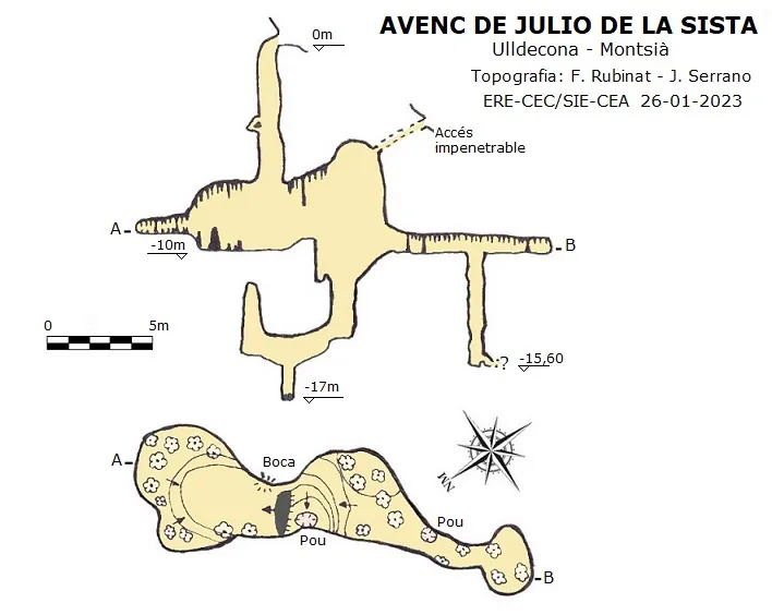
Espeleoindex · CC BY-NC 4.0, https://creativecommons.org/licenses/by-nc/4.0/ · Immagine © del suo autore.
Foto
Espeleoindex · CC BY-NC 4.0, https://creativecommons.org/licenses/by-nc/4.0/ · Immagine © del suo autore.
Descrizione
Morfologia
Through the narrow entrance, equipped with 2 8mm stainless steel parabolds, one enters a 10-metre vertical shaft; up to the middle of the shaft it is a narrow conduit. At this point, behind us, there is a rock bridge on which to place a deviation to avoid the rope rubbing; from here on the shaft widens a little. A couple of metres further down, before reaching the roof of the chamber, we find a spit that is completely unnecessary.
Once at the base of the -10m shaft we enter a chamber. The total route is 45 metres, while the depth is -17 metres.
Concrezioni
Once at the base of the -10m shaft we enter a chamber where, in a NE direction, we find an abundant lithogenic formation, while on the SW side we find a step that can be avoided by passing along the left-hand side of the chamber, where we also find some column-shaped formations; these make it easier to rig a rope to descend the slope and the small final shaft. If from the columns we traverse towards the SW, we reach an area with a lot of formation; just before entering it, on the roof of the chamber we see a small conduit through which the daylight is visible; this comes from a small entrance outside, a little below the entrance. Continuing through the formation area, one can crawl until reaching a 6-metre-deep shaft; at the base we find a conduit that continues but is excessively narrow. Back at the head of the shaft, one continues crawling among the formation until reaching a small chamber, where abundant roots appear among the stalactites on the roof.
Progressione
Through the narrow entrance, equipped with 2 8mm stainless steel parabolds, one enters a 10-metre vertical shaft. Once at the base of the -10m shaft we enter a chamber; on the SW side we find a step that can be avoided by passing along the left-hand side of the chamber, where the column-shaped formations make it easier to rig a rope to descend the slope and the small final shaft. If from the columns we traverse towards the SW, we reach an area with a lot of formation. Continuing through the formation area, one can crawl until reaching a 6-metre-deep shaft; at the base we find a conduit that continues but is excessively narrow. Back at the head of the shaft, one continues crawling among the formation until reaching a small chamber.
Storia
Cavity known to very few people of the area. In fact it had remained unrecorded until the end of December 2018, when, with prior indications of its location provided by Agustí Barceló, it was visited by Pep Badia and Agustí Adons.
Note from Espeleoíndex: Although we had never had any news of this cavity until now, nor whether it had been explored previously, we have found it georeferenced (without specifying the name) on the hiking map 'Serra de Montsià', scale 1:20,000, published in 1999 by the Patronat Municipal d'Acció Cultural de l'Ajuntament de Sant Carles de la Ràpita.
Commenti degli utenti (0)
Nessun commento ancora.
Sii il primo a condividere la tua esperienza!
Esplorazioni registrate (0)
Nessuna esplorazione registrata.
Registra la tua visita a questa grotta!
Bibliografia
- Dades, coordenades i fotos de la boca han estat extretes del blog:senderes.blogspot.com (de Pep Badia, la Ràpita) inclou track de la ruta. Apunt del 29-12-2018.
- Actualització de dades, topografia i fotografies interiors facilitades per Juli Serrano (SIE-CEA) i Francesc Rubinat (ERE-CEC).Gener de 2023.
Grotte vicine




Fonte: Espeleoindex (espeleoindex.com), modificato. CC BY-NC 4.0, https://creativecommons.org/licenses/by-nc/4.0/