
Forat del Coll dels Trulls
A 12-metre-deep pit at Coll de Trulls (Gisclareny), explored in 1990 by the SIES d'Esplugues de Llobregat.
EspeleoWorld
Forat del Coll dels Trulls
A 12-metre-deep pit at Coll de Trulls (Gisclareny), explored in 1990 by the SIES d'Esplugues de Llobregat.
Gisclareny · Berguedà
Length: 19 m · Depth: 12 m
Updated record
https://espeleoworld.com/en/c/forat-del-coll-dels-trulls
Information can change. Always verify coordinates, access, weather, and cave conditions before setting out.
A 12-metre-deep pit at Coll de Trulls (Gisclareny), explored in 1990 by the SIES d'Esplugues de Llobregat.
Topographic
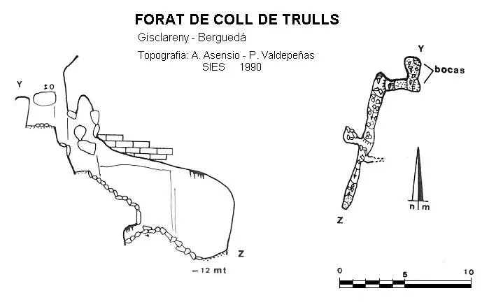
Espeleoindex · CC BY-NC 4.0, https://creativecommons.org/licenses/by-nc/4.0/ · Image © its author.
Description
Morphology
A small shaft opened beneath a stratum gives access to a small chamber where we find a step that leads us to a descending gallery with a rectilinear plan.
History
Explored in 1990 by the SIES d'Esplugues de Llobregat.
The designation of the acronym “M” is meant to indicate Moixeró. In the same area is the cova de la Roca Tallada (M-8), with 62 metres of passage and -10 metres of elevation change, but we have no further data about it.
User Comments (0)
No comments yet.
Be the first to share your experience!
Registered Explorations (0)
No explorations registered yet.
Register your visit to this cave!
Bibliography
- Asensio Vela, Antoni.(1997).-”Exploracions a la Serra del Cadí”. Cavernes (24):61-64. GE Badalona.
- SIES (1990).-”Cadí 90”. Memòria de campanya 1990. SIES-CCR l'Avenç. Esplugues de Llobregat.
- Valles, Jordi de.(2009).-”Berguedà, Cerdanya, Garrotxa, Ripollès”. Catàleg Espeleològic de Catalunya (vol.3):44-45. EC Gràcia/FCE.
Nearby caves

Source: Espeleoindex (espeleoindex.com), modified. CC BY-NC 4.0, https://creativecommons.org/licenses/by-nc/4.0/