
Forat de la Baga de Can Torrela
A tiny cavity long known in Bigues i Riells, explored on 26 July 1897 by Norbert Font i Sagué and the Maspons Angladell brothers, Pere Pagès and Maspons Camarasa, who descended 13 metres through a narrow fissure. Currently collapsed at -1.45 metres.
EspeleoWorld
Forat de la Baga de Can Torrela
A tiny cavity long known in Bigues i Riells, explored on 26 July 1897 by Norbert Font i Sagué and the Maspons Angladell brothers, Pere Pagès and Maspons Camarasa, who descended 13 metres through a narrow fissure. Currently collapsed at -1.45 metres.
Bigues i Riells · Vallès Oriental
Length: 4 m · Depth: 1 m
Updated record
https://espeleoworld.com/en/c/forat-de-la-baga-de-can-torrela
Information can change. Always verify coordinates, access, weather, and cave conditions before setting out.
A tiny cavity long known in Bigues i Riells, explored on 26 July 1897 by Norbert Font i Sagué and the Maspons Angladell brothers, Pere Pagès and Maspons Camarasa, who descended 13 metres through a narrow fissure. Currently collapsed at -1.45 metres.
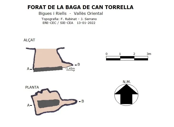
Topographic
Espeleoindex · CC BY-NC 4.0, https://creativecommons.org/licenses/by-nc/4.0/ · Image © its author.
Photos
Espeleoindex · CC BY-NC 4.0, https://creativecommons.org/licenses/by-nc/4.0/ · Image © its author.
Description
Morphology
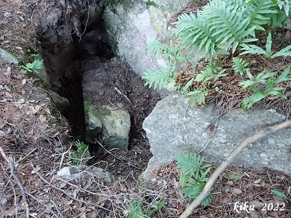
The cavity is completely collapsed at -1.45 metres; a large block that appears to have shifted occupies almost the entire floor, and its sides are full of earth.
Hydrology
On the E side, where the fissure narrows, a faint current of air emerges.
Progression
The exploration carried out on 26 July 1897 by Norbert Font i Sagué in the company of the Maspons Angladell brothers, Pere Pagès and Maspons Camarasa, leaves a written record that they descended 13 metres through a rather narrow fissure that ended collapsed by rubble.
History
The first mention of this cavity appears under the name Forat del Bach del Prat, in the April 1897 bulletin of the Centre Excursionista, within Font i Sagué's Catàleg Espeleològic de Catalunya, as a result of the enquiries made to members of the Centre Excursionista de Catalunya about knowledge of cavities in the country; it is clear that the location is not very precise, since they place it on a shady slope, while in reality the cavity is on top of a ridge.
On 26 July of the same year Font i Sagué visits and explores it accompanied by local people, cataloguing it under the name Forat de la Baga de Can Torrella in the December 1897 bulletin.
One year later, 1898, Font i Sagué publishes in the July bulletin the account of the exploration carried out the previous year.
The passing of the years led this cavity into oblivion, but in the catalogues of the 80s it appears cited, in addition to the previous names, under the name Forat de Can Prat de la Riba, which we suppose is due to its proximity to that farmhouse.
User Comments (0)
No comments yet.
Be the first to share your experience!
Registered Explorations (0)
No explorations registered yet.
Register your visit to this cave!
Bibliography
- Borràs, J.; Miñarro, J.M.; Talavera, F. (1982).-”el Baix Empordà, el Gironès, la Selva, l'Osona, el Vallès Oriental i el Maresme”. Catàleg Espeleològic de Catalunya (vol.6):1-292. Ed. Políglota. Barcelona.
- Font i Sagué, Norbert (1897).-”Catalech Espeleologich de Catalunya, continuació”. Butlletí del Centre Excursionista de Catalunya (27):141-149. Barcelona.
- Font i Sagué, Norbert (1897).-”Catalech Espeleologich de Catalunya, acabament”. Butlletí del Centre Excursionista de Catalunya (35):311-323. Barcelona.
- Font i Sagué, Norbert (1898).-”Excursió espeleologica a La Bancó, Les Barbotes i Singles de Berti, continuació.” Butlletí del Centre Excursionista de Catalunya (42):184-196. Barcelona.
- Valles, Jordi de (2016).-”Bages, Barcelonès, Maresme, Vallès Occidental, Vallès Oriental”. Catàleg Espeleològic de Catalunya (Vol.5):1-560. EC Gràcia/FCE.
- Totes les dades, coordenades, topografia i fotografies han estat facilitades per Juli Serrano (SIE-CEA) i Francesc Rubinat (ERE-CEC).
Nearby caves


Source: Espeleoindex (espeleoindex.com), modified. CC BY-NC 4.0, https://creativecommons.org/licenses/by-nc/4.0/