
Cova del Riu
A salt cavity in Cardona, formed by the collapse of the floor of a mining gallery called Minilla. It includes a large chamber and a lower gallery that ends at the salt-sandstone contact.
EspeleoWorld
Cova del Riu
A salt cavity in Cardona, formed by the collapse of the floor of a mining gallery called Minilla. It includes a large chamber and a lower gallery that ends at the salt-sandstone contact.
Cardona · Bages
Length: 260 m · Depth: 5 m
Updated record
https://espeleoworld.com/en/c/cova-del-riu
Information can change. Always verify coordinates, access, weather, and cave conditions before setting out.
A salt cavity in Cardona, formed by the collapse of the floor of a mining gallery called Minilla. It includes a large chamber and a lower gallery that ends at the salt-sandstone contact.
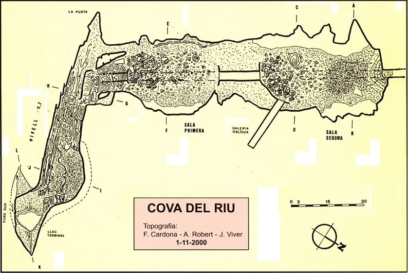
Topographic
Espeleoindex · CC BY-NC 4.0, https://creativecommons.org/licenses/by-nc/4.0/ · Image © its author.
Photos
Espeleoindex · CC BY-NC 4.0, https://creativecommons.org/licenses/by-nc/4.0/ · Image © its author.
Description
Morphology
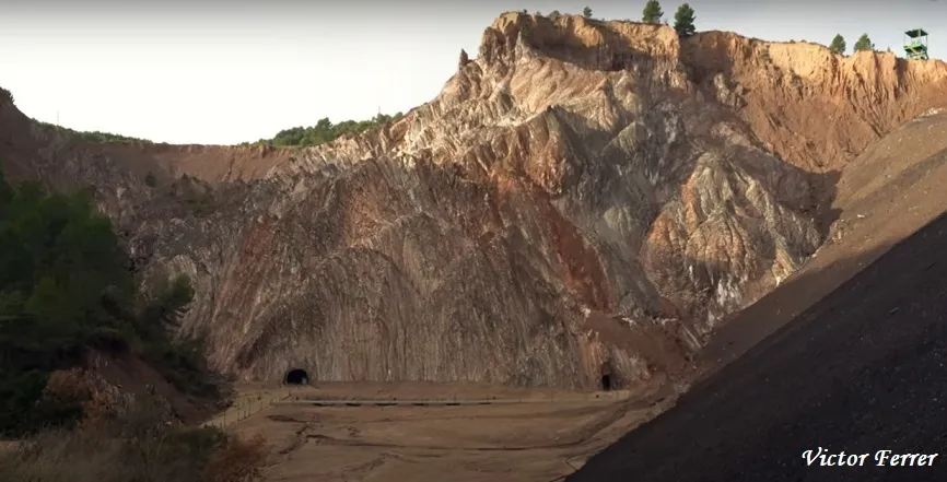
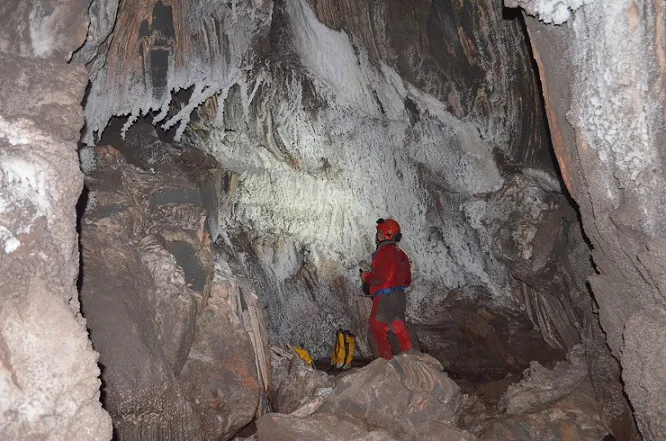
This is a speleological phenomenon that is difficult to classify genetically. In fact it is a natural cave whose formation was determined by a pre-existing mining gallery, popularly known by the name Minilla, which implies that it is later than it and represents another clear example of the fragility of the saline environment in the face of anthropogenic actions. The cave itself is very spacious and develops beneath a good part of the gallery of the Minilla, which leads towards the Maria Teresa shaft. The progressive collapse of its floor has managed to create a large chamber about 110 metres long, with widths that come to exceed 30 metres, and heights on the order of 10 metres. Throughout, its walls and ceiling preserve the morphology derived from the lacustrine stage, when it was occupied by large volumes of water. At one end of the chamber, the cavity turns nearly 90º and continues along another also spacious gallery, located at a lower level, which ends at the salt-sandstone contact; climbing up it, one reaches the mining gallery, already excavated in sandstone, which leads to the Maria Teresa shaft.
Hydrology
Through the mining gallery that leads to the Maria Teresa shaft, fresh water coming from a spring located near the shaft reached the cave. In 1998, on the occasion of the entry of water into the mine where rock salt is exploited, the hydrogeology of the entire salt deposit is profoundly altered. As a consequence of this, the large lake of the cave disappears and, up to the present date, the cavity remains dry, except for the terminal lake.
Progression
On 06-09-1997 members of the ECG carried out the first exploration, with the need to use a pneumatic boat to cross the lake. On the eleventh of November 1997 the second exploration also carried out by members of the ECG took place; this time the pump has been made to work more and the water level is noticeably lower, but there are large accumulations of mud; despite this they can reach the Maria Teresa shaft; shortly before they see the fresh-water spring, which flows towards the cavity. A new exploration on 19-04-2002 confirms the collapse of the mine gallery that leads to the Maria Teresa shaft, about 50 metres before reaching it.
Other details
On 20-09-1964 members of the SIE of the CEA visit the mina de la Sal Roja, currently known as the Minilla, where they observe some phenomena of salt collapses, but they do not detect any anomaly in the floor. About two years later, on 06-02-1966, they return again, just after a collapse of the floor had occurred a few days earlier that allowed access to what would be called the Galeria de la Muntanya, today known as Cova del Riu. They communicate the details of the exploration to members of the ERE of the CEC, who begin explorations in the area on 19 and 20 March of that same year. On 05-03-1967 members of the ERE of the CEC carry out the survey of the Cova de la Galeria de la Muntanya de la Sal Roja on behalf of the mining company (U.E.E.S.A.). Fèlix Alabart also takes part, photographing the cavity. In the following years, miners who enter the Minilla to carry out maintenance of the pump that removes the water find more and increasingly larger holes in the floor of the gallery, which forces them to place wooden walkways to overcome the obstacles. Later the Minilla is closed off completely by placing grilles and a masonry wall at its mouth. Once the potash mining exploitation stage was over (the mine closed in 1990), it became the object of tourist exploitation. In 1995 the interior of the Minilla is accessed, and it is observed that upon reaching a point the floor disappears and gives access to a void of enormous dimensions with its bottom occupied by a lake of great width, while further on the mining gallery continues hanging at a certain height. The stretch where the collapse is located is then set aside from the itinerary planned for tourist visits, for which reason they close it with a grille. The grille has another significance: it divides the Minilla into two sectors with different legal regimes. On the one hand there is the tourist sector, where work is being done to condition it; on the other hand, beyond the grille we find ourselves in mining territory, dependent on the autonomous mining authorities. By 1997, with tourist visits already operational and given the need to know to what extent the cova del Riu (cave of the Riu) or whatever it may be could compromise the safety of the tourist sector, the speleologists are finally contacted to carry out the exploration. It is agreed to carry out a first exploration in September 1997, but first the lake must be partially emptied by means of a powerful pump that runs night and day for a week. During the year 2000, and on behalf of the Direcció General d'Energia i Mines, the speleologists carry out an in-depth study of the cave, especially aimed at the safety of the tourist exploitation. At the beginning of 2001 the stretch of mine gallery that remained hanging in the middle of the cavity and that served as a separation between the two main halls collapses.
User Comments (0)
No comments yet.
Be the first to share your experience!
Registered Explorations (0)
No explorations registered yet.
Register your visit to this cave!
Bibliography
- Cardona, F.(1999).-”La cova del Riu (Muntanya de sal de Cardona)” Exploracions (19):37-44. ECG.
- Cardona, F.; Viver, J. (2002).-Sota la Sal de Cardona pp.1-128. EC Gràcia.
- Cardona Olivan, F. (2003).-”Sota la sal de Cardona”. Espeleo-Cat (1):19-22. FCE. Barcelona.
- Cardona Olivan, F. (2004).-”Morfogènesi de les cavitats en sal de Cardona”. Actes 1er Congrés Català Espeleologia pp:157-166. FCE.
- Moreno Segura, M.C.; Victoria López, J.M.(1969).-”El Karst Salino de Cardona”. EspeleoSie (4):20-26. SIE-CEA.
- Valles, J. De (2016).-”Bages, Barcelonès, Maresme, Vallès Occidental, Vallès Oriental” Catàleg Espeleològic de Catalunya (vol.5):1-560. ECG/FCE.
- Topografia inèdita (1967), extreta de l'arxiu de l'ERE - CEC
- Fotografies de Fèlix Alabart, corresponents a l'exploració de 1967.
- Fotografies modificades corresponents a la Cova del Riu, extretes del llibre “Sota la Sal de Cardona” de Ferran Cardona i Josep Viver.
- Totes les fotografies de la part turística de la Minilla han estat facilitades per Victor Ferrer Rico (Flash Black Corb)
Nearby caves


Source: Espeleoindex (espeleoindex.com), modified. CC BY-NC 4.0, https://creativecommons.org/licenses/by-nc/4.0/