
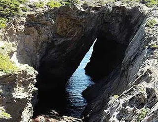
Cova de S'Infern
Very well-known sea cave at Cap de Creus (Cadaqués), today a 35-metre rock bridge within the Integral Natural Reserve.
EspeleoWorld
Cova de S'Infern
Very well-known sea cave at Cap de Creus (Cadaqués), today a 35-metre rock bridge within the Integral Natural Reserve.
Cadaqués · Alt Empordà
Length: 50 m · Depth: 11 m
Updated record
https://espeleoworld.com/en/c/cova-de-s-infern
Information can change. Always verify coordinates, access, weather, and cave conditions before setting out.
Very well-known sea cave at Cap de Creus (Cadaqués), today a 35-metre rock bridge within the Integral Natural Reserve.
Photos
Espeleoindex · CC BY-NC 4.0, https://creativecommons.org/licenses/by-nc/4.0/ · Image © its author.
Description
Morphology
Today it is simply a rock bridge 35 metres in length resulting from the destruction of part of the roof of the pre-existing cave; it remains a phenomenon as interesting as it is spectacular and for this reason it constitutes a point of interest on walking itinerary no. 15 (geological) of the Natural Park.
Marine erosion cavity, excavated taking advantage of one of the faults that orient the coves of Cap de Creus.
Progression
Access from land must be made through the roofless section by means of an 11-metre vertical drop.
Other details
We do not know of any survey of the cavity.
History
Known since time immemorial by fishermen and local people. It appears to already feature on a map of the Principality from the 17th century (Boscano, 1687). Cited in all the old catalogues, beginning with Madoz (1850), Casiano del Prado (1864), Puig y Larraz (1896), Font i Sagué (1897), etc.
For some years it has also been very well known to kayakers, divers and lovers of hidden places.
Lately it is also frequented by enthusiasts of jumping into the water from increasing heights; the shallow depth of the innermost point has already caused accidents due to the lack of sufficient water cushion.
User Comments (0)
No comments yet.
Be the first to share your experience!
Registered Explorations (0)
No explorations registered yet.
Register your visit to this cave!
Bibliography
- Valles, Jordi de (2010).- Catàleg Espeleològic de Catalunya. Volum 4: 397 pp. Espeleo Club de Gràcia / Federació Catalana d'Espeleologia. Barcelona.
- Altres dades i fotografies extretes del blog: espeleobloc.blogspot (apunt del 15-4-2010)
Nearby caves

Source: Espeleoindex (espeleoindex.com), modified. CC BY-NC 4.0, https://creativecommons.org/licenses/by-nc/4.0/