
Cova de la Dou
A 77 m long cave in l'Arbolí (Baix Camp), of archaeological interest, discovered in 1934 and explored in 2014.
EspeleoWorld
Cova de la Dou
A 77 m long cave in l'Arbolí (Baix Camp), of archaeological interest, discovered in 1934 and explored in 2014.
Arbolí · Baix Camp
Length: 77 m · Depth: 10 m
Updated record
https://espeleoworld.com/en/c/cova-de-la-dou
Information can change. Always verify coordinates, access, weather, and cave conditions before setting out.
A 77 m long cave in l'Arbolí (Baix Camp), of archaeological interest, discovered in 1934 and explored in 2014.
Topographic
Espeleoindex · CC BY-NC 4.0, https://creativecommons.org/licenses/by-nc/4.0/ · Image © its author.
Photos
Espeleoindex · CC BY-NC 4.0, https://creativecommons.org/licenses/by-nc/4.0/ · Image © its author.
Description
Morphology
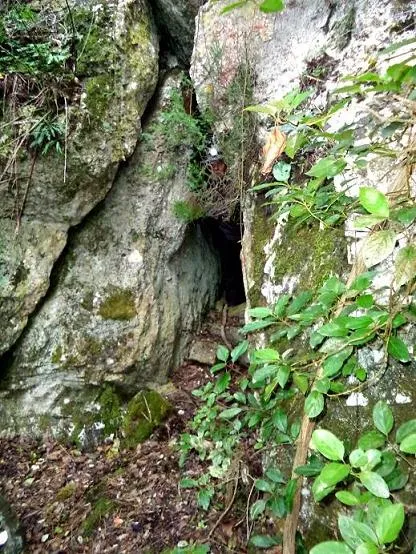
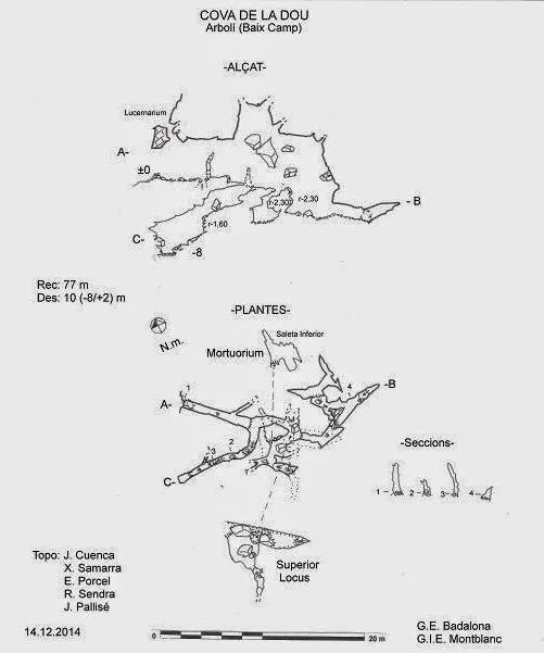
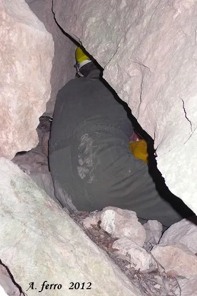
The entrance is triangular in shape, 0.70x2.50 metres, and allows one to enter upright. A few metres in we observe a second opening in the ceiling, a skylight or exit through which light enters, and we find a straight passage oriented to the SE. At 8 metres there is a small and impenetrable gallery on the left, and at 10 metres we have a branch on the right. If we go into this branch, we find a descending gallery, about 10 metres long, with several drops that leads to the terminus of the cave and its maximum depth of -8 metres. This joint has dimensions of about 0.4 metres wide by variable heights of 1 to 3 metres. The end is a small pool of water accumulated when it rains. Returning to the branch, we find a joint 6 metres high, where large wedged blocks form an upper floor. We will advance following the SE direction of the entrance gallery for about 3 metres, here we find another fork. If we go to the right a ramp will take us to an R-2.3 metres, leaving small branches without continuation on the left. Having descended the drop we find a small room “Mortuorium” where we move among disturbed remains of bones and ceramics from the Bronze Age site, unfortunately the little that remains from the looting done by amateurs and from old archaeological excavations that left everything stirred up and out of context. Returning to the aforementioned fork of the main gallery (the one located 3 metres after the branch), we continue forward and descend another R-2.30 m. At 3 metres the gallery turns slightly to the left in an E direction, easy to traverse, ending at 6 metres of passage. Three metres before, a passage takes us to some squeezes that gradually close, except one that turns left shortly after entering and returns to the gallery making some zigzags. Finally, if we return to the previous fork, we will have to climb an E+2.20, and with ease we access the upper floor (Superior Locus) above some fallen rocks where a room is formed; if we ascend in a S direction, we will find a squeeze that ends at 4 metres. If we go down in a N direction, at 5 metres we will descend an R-1.70 metres and close a circuit, since we have arrived where the first branch of the entrance gallery begins.
Hydrology
The end is a small pool of water accumulated when it rains.
Progression
The entrance is triangular in shape, 0.70x2.50 metres, and allows one to enter upright. A few metres in we observe a second opening in the ceiling, a skylight or exit through which light enters, and we find a straight passage oriented to the SE. At 8 metres there is a small and impenetrable gallery on the left, and at 10 metres we have a branch on the right. If we go into this branch, we find a descending gallery, about 10 metres long, with several drops that leads to the terminus of the cave and its maximum depth of -8 metres. This joint has dimensions of about 0.4 metres wide by variable heights of 1 to 3 metres. The end is a small pool of water accumulated when it rains. Returning to the branch, we find a joint 6 metres high, where large wedged blocks form an upper floor. We will advance following the SE direction of the entrance gallery for about 3 metres, here we find another fork. If we go to the right a ramp will take us to an R-2.3 metres, leaving small branches without continuation on the left. Having descended the drop we find a small room “Mortuorium” where we move among disturbed remains of bones and ceramics from the Bronze Age site, unfortunately the little that remains from the looting done by amateurs and from old archaeological excavations that left everything stirred up and out of context. Returning to the aforementioned fork of the main gallery (the one located 3 metres after the branch), we continue forward and descend another R-2.30 m. At 3 metres the gallery turns slightly to the left in an E direction, easy to traverse, ending at 6 metres of passage. Three metres before, a passage takes us to some squeezes that gradually close, except one that turns left shortly after entering and returns to the gallery making some zigzags. Finally, if we return to the previous fork, we will have to climb an E+2.20, and with ease we access the upper floor (Superior Locus) above some fallen rocks where a room is formed; if we ascend in a S direction, we will find a squeeze that ends at 4 metres. If we go down in a N direction, at 5 metres we will descend an R-1.70 metres and close a circuit, since we have arrived where the first branch of the entrance gallery begins.
Other details
Cave 77 m long, of archaeological interest, in l'Arbolí (Baix Camp).
History
The cavity was discovered by J. Lloret in 1934 and was excavated by Dr. Vilaseca with the collaboration of the owner, Josep Salvadó, and Joan Carrer, both from Arbolí. The same year the corresponding publication appeared in the Butlletí de la Societat Arqueològica Tarraconense. References to the various finds from Arbolí can also be found in the three synthesis books by Vilaseca. In 1984, in volume no. 7 of the Catàleg Espeleològic de Catalunya the authors say they did not locate it. We have no record of any further exploration until, on the occasion of the preparation of the book on cavities of the serra de Prades, and after visiting the pit del Pep Ton, in the summer of 2014 we got in contact by email with Rafel Ferré de Reus who in a blog on old paths indicated that he had located it: “En Joan Josep Estivill commented on a cave there in the obaga de la Vall d’Arbolí, which was not located by the authors of the Catàleg Espeleològic de Catalunya and which he was trying to find. Then I remembered a trace that I had followed when searching for the Grau del Gallarí. So I went back and, more or less, that trace had continuity. Moreover, I was able to locate the cave: El Forat or Cova de la Dou, which was explored by Dr. Salvador Vilaseca. This cave was initially located between the years 1920 and 1930 by the schoolmasters of Arbolí, Sr. Porta, and of Alforja, Sr. Lloret, who helped him in the search through their territory. The name often makes the thing, but that hole had nothing to do with a spring. Therefore, it could not be a dou, or font in old Catalan. Nevertheless, it is thanks to the archaeologists that this toponym has survived in the written documentation. However, the doubt remains more alive than ever. At the Mas de Gallarí they commented to me that the Dou referred to that territory, that is, to a parcel of land in the municipality of Arbolí, although they were well aware of the meaning of Dou. Could it be that the Dou really referred to the Font del Bres? This spring is one of the most important springs of the Muntanyes de Prades and has been used since ancient times by a host of mills. I do not know the answer”. In October 2014 the same Rafel Ferré accompanied members of the GIE Montblanc and they carried out the exploration and the first biospeleological research, locating the first specimens of cave beetles. On a later visit they set traps and on 14 December 2014, members of the GIE Montblanc and GE Badalona made an extensive photographic report and the survey of the cavity.
Bio
In October 2014 the same Rafel Ferré accompanied members of the GIE Montblanc and they carried out the exploration and the first biospeleological research, locating the first specimens of cave beetles.
User Comments (0)
No comments yet.
Be the first to share your experience!
Registered Explorations (0)
No explorations registered yet.
Register your visit to this cave!
Bibliography
- Vilaseca, S. (1934).- “Les coves d'Arbolí”. Butlletí Arqueològic (49): 382-385. Societat Arqueològica Tarraconense.
- Totes les dades, topografia i fotografies han estat extretes del blog: espeleobloc.blogspot Apunt del 20-3-2015. Text fitxa: Joan Pallisé (GIEM) i Enric Porcel (GEB). Fotografies: F.X Samarra, E. Porcel i J. Cuenca (GEB)
Nearby caves



Source: Espeleoindex (espeleoindex.com), modified. CC BY-NC 4.0, https://creativecommons.org/licenses/by-nc/4.0/