
Avenc Gran d'Aulà
Important cavity with 155 m of vertical drop in Alt Àneu, at the port d'Aulà (2262 m). Discovered in July 1975 by the SS Plantaurel and the ASMP; in 1984 the maximum depth was fixed at the -155 level.
EspeleoWorld
Avenc Gran d'Aulà
Important cavity with 155 m of vertical drop in Alt Àneu, at the port d'Aulà (2262 m). Discovered in July 1975 by the SS Plantaurel and the ASMP; in 1984 the maximum depth was fixed at the -155 level.
Alt Àneu · Pallars Sobirà
Length: 1530 m · Depth: 155 m
Updated record
https://espeleoworld.com/en/c/avenc-gran-d-aula
Information can change. Always verify coordinates, access, weather, and cave conditions before setting out.
Important cavity with 155 m of vertical drop in Alt Àneu, at the port d'Aulà (2262 m). Discovered in July 1975 by the SS Plantaurel and the ASMP; in 1984 the maximum depth was fixed at the -155 level.
Topographic
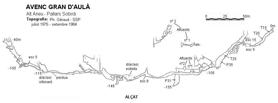
Espeleoindex · CC BY-NC 4.0, https://creativecommons.org/licenses/by-nc/4.0/ · Image © its author.
Description
Morphology
The cavity opens in a small porch 1 metre high by 0.5 wide that protects it from the snow and through which a strong draught normally blows. It begins with a steep slope, a step and a second slide. At its end, the gallery continues on a steep slope and continues horizontally for 50 metres until reaching the -50 level. Here, a 10-metre climb (in two sections) gives access to a large chamber. From here a wide gallery on a steep slope leaves and ends in two pits of 7 and 13 metres (-105 level), where the Gran Sala del Caos is found. Important junction.
1. To the right a gallery leaves and ends blocked by collapses 50 metres further on, but 20 metres before, to the right, an 8-metre pit leads to a meander that after 40 metres opens into a magnificent bell-shaped pit of 31 metres. Its floor (20 x 15 m) is choked with collapses and constitutes the lowest point of the cavity (-155 level).
2. On the left wall, a climb over a stalagmitic flow leads to a gallery whose floor is swept with blocks and which ends at 35 or 40 metres at the base of an important chimney. A 10-metre climb at the start of the gallery has given no results.
3. To the left of the Sala del Caos (west side) a gallery leaves, almost cut at the start by an 8-metre pit between the blocks, followed by a 6-metre climb and continues over a route of 250 metres that ends in an impenetrable sandy passage. To the right, a low passage gives access to an ascending joint that after 15 metres becomes a horizontal passage where a 12-metre blind pit is found and further on, a 15-metre slide at the start of which a new 16-metre pit opens, choked (-148 level).
The continuation of the main gallery is a strong ascending ramp, at the top of which, to the left, a large joint 60 metres long by 30 of vertical drop is found, up to a very narrow vertical passage. The main gallery still continues some 50 metres further on to a zone of unstable blocks.
The continuation of the cavity is found under the blocks, on the right wall. These are 110 metres of galleries, with a clayey floor and low-ceilinged zones, which lead to a flooded floor. After this zone, the gallery climbs on a steep slope and, 50 metres further on, is blocked by blocks. (End of explorations of 1975 and 1976; -100 level).
During the 1984 campaign, the continuation was discovered thanks to a 6-metre climb on the right wall of the main gallery, 15 metres before its end. A beautiful horizontal gallery leads, in 15 metres, to a chamber full of blocks and between which about 10 metres can be descended. From the upper part a gallery climbs between very unstable blocks and, with great danger, almost 70 metres of vertical drop can be climbed (-40 level), where impenetrable fissures that, from the draught, seem to indicate the way to the exterior, but blocked by a great chaos of blocks.
Speleothems
On the left wall, a climb over a stalagmitic flow leads to a gallery whose floor is swept with blocks.
Hydrology
The meander of access to the P-31 receives two tributaries. Tributary no. 2, at the middle of the 40-metre meander, before reaching the P-31, is accessed by a 9-metre climb in opposition, followed by a meagre trickle of water, climbs on a steep slope, narrow, and ends in a plug of large blocks. Development: 98 metres.
The continuation of the cavity is found under the blocks, on the right wall. These are 110 metres of galleries, with a clayey floor and low-ceilinged zones, which lead to a flooded floor where the water level can vary appreciably depending on the time of year or the snow accumulated outside. To the right, a flooded joint is visible for quite a few metres.
Progression
The access meander to the P-31 receives two tributaries:
Tributary no. 1 3 metres from the base of the P-8 by a 7-metre climb. Very narrow and ends in a chamber of 10 x 3 metres, from which narrow passages of short length leave. Development: 66.5 metres.
Tributary no. 2 – At the middle of the 40-metre meander, before reaching the P-31. Access by a 9-metre climb in opposition, followed by a meagre trickle of water, climbs on a steep slope, narrow, and ends in a plug of large blocks. Development: 98 metres.
History
Discovered and partially explored during the campaign of the SS Plantaurel and the ASMP during the month of July 1975. They assign it a vertical drop of -146 m and an approximate route of 1250 m (1028 m surveyed).
They do not return until the summer of 1979, when they explore tributary no. 2.
A new visit by the SSP in the summer of 1984 results in the exploration of different galleries and the completion of the survey, fixing the maximum depth at the -155 level.
User Comments (0)
No comments yet.
Be the first to share your experience!
Registered Explorations (0)
No explorations registered yet.
Register your visit to this cave!
Bibliography
- Cardona, F. (1989).- Grans cavitats de Catalunya. Vol. 1: La Serralada Pirinenca. 198 pp. EC Gràcia. Barcelona.
- Inglés, A. (1983).- “Tres avencs de 100 en el Pirineu català” Espeleòleg (34-35): 244-251. ERE del CEC. Barcelona.
- Lesage, B.; Géraud, Ph.; Gratté, L. (1977).- “Les Cuns d'Aula”. Ouarnède (8): 25-32. G.S.Pyrenées. Toulouse.
- Géraud, Ph. (1984).- “Le gouffre C7”. L'Echo des Ténébres (15): 58-62. S.S.Plantaurel. Lavelanet.
- S.S.Plantaurel.- Memòries i documents inèdits
Nearby caves
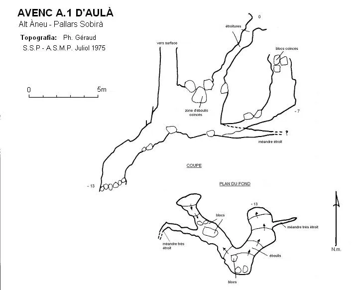

Source: Espeleoindex (espeleoindex.com), modified. CC BY-NC 4.0, https://creativecommons.org/licenses/by-nc/4.0/