
Avenc de la Sivinota
Historic and important pit in Garraf, with a 106 m vertical drop and 132 m total depth, in Garraf (Gavà).
EspeleoWorld
Avenc de la Sivinota
Historic and important pit in Garraf, with a 106 m vertical drop and 132 m total depth, in Garraf (Gavà).
Gavà · Baix Llobregat
Length: 202 m · Depth: 132 m
Updated record
https://espeleoworld.com/en/c/avenc-de-la-sivinota
Information can change. Always verify coordinates, access, weather, and cave conditions before setting out.
Historic and important pit in Garraf, with a 106 m vertical drop and 132 m total depth, in Garraf (Gavà).
Topographic
Espeleoindex · CC BY-NC 4.0, https://creativecommons.org/licenses/by-nc/4.0/ · Image © its author.
Photos
Espeleoindex · CC BY-NC 4.0, https://creativecommons.org/licenses/by-nc/4.0/ · Image © its author.
Description
Morphology
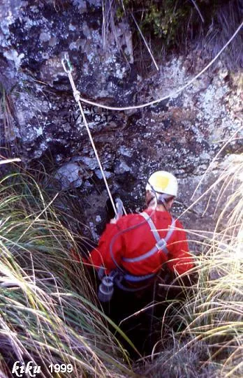
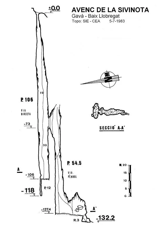
A circular entrance just over 1 metre in diameter gives access to a magnificent shaft, fusiform in shape and 106 metres in vertical drop. At one end of its base a narrow shaft 12 metres deep opens, reaching the level of -118.
At 33 metres above the base of the shaft a wide window opens, giving access to a lateral shaft 54.5 metres deep. Its base is about 4 metres wide and extends for 20 metres until at its end a small 3-metre shaft is found, at the bottom of which the point of maximum depth is reached.
Progression
The third exploration was also epic; in September 1953 members of the GES decided to descend and ascend the shaft using a new technique that allowed them not to have to transport more than 100 metres of ladders: The explorers were lowered and raised by means of a rope that passed through a pulley “solidly” secured over the entrance of the pit. A second rope acted as a safety rope thanks to a Prusik knot that joined it by a sling to the explorer's waist. In this way, whoever descended or ascended had to try to keep the Prusik knot loose so that it would slide along the safety rope. In case of rupture of the hauling rope, the Prusik knot would become constricted on the safety rope and would hold the explorer. All went well until it was Lluís Muntan's turn to ascend. When he was halfway down the pit, with more than 50 metres below his feet, the pulley of the hauling rope tore off. Fortunately, the safety system worked as planned and, when the Prusik knot became constricted, Muntan was left hanging from the safety rope. (Account taken from “Avencs i coves”, Francesc Vicens, 1958).
Our friend Lluís Muntan gives us the account of his experience in more detail: All went well until it was Lluís Muntan's turn to ascend. When he was halfway down the pit, with more than 50 metres below his feet, the rigging tore off, large stones falling down. Muntan heard them pass brushing against his body. Fortunately they did not touch him and the safety system worked as planned; when the Prusik knot became constricted, Muntan was left hanging from the safety rope until, at the top, they fixed the rigging. He began the ascent again and after a few metres it tore off again and stones fell down once more. And again he heard the whirring very close to his body. Quite an experience, which he still remembers as if it were today. The luck was that 20 metres from the entrance there is a ledge that diverted the stones. Otherwise, they would surely have hit him and crushed him, since the shaft, as you well know, is completely bell-shaped.
Again members of the GES, in May 1961, during a new exploration and performing a spectacular pendulum more than 30 metres above the base of the shaft, manage to reach a window that leads them to a lateral shaft (Via Pèndol) where they were able to reach the maximum depth of the cavity.
Other details
Toponymy: For more than 80 years, since Font i Sagué, the name of the pit had been wrongly written Sibinota, when Sivinota seems more correct, coming from sivina, a dialectal form of savina (Juniperus phoenicea).
History
The first news of the cavity is given by N. Font i Sagué when on 21 July 1898 he sounded the shaft, calculating a depth of 90 metres, giving up his exploration for lack of material.
Twenty-five years later, on 11 September 1923, R. Amat i Carreras, trusting the previous data, began the first exploration, but on reaching the end of the ladder he found that it did not reach the bottom and, believing he saw the bottom very close, he lowered himself by a rope tied to the end of the ladder and with a wooden crossbar at the end that fortunately for him also did not reach the ground, for shortly after beginning the descent, his tired hands slipped along the rope and he was stopped on the crossbar about 2 metres from the bottom. From here he jumped to the base of the shaft and remained “buried” alive for some 8 hours until his companions had to go to Begues to fetch more ladders. When he came out he was convinced that he would be the first and last man to descend that pit.
The second exploration was not carried out until many years later, specifically in April 1949, by the newly created GES del CMB.
On a new visit by the GES in March 1958, they observe that at the bottom of the shaft a new shaft has opened through which they can descend 12 metres more.
Bio
Troglocharinus Ferreri Reitt.
8 - XII - 1966, 2 exemplars.
13 - VII - 1969, 5 exemplars.
25 - X - 1981, 5 females and 6 males.
All collected by Oleguer Escolà.
User Comments (0)
No comments yet.
Be the first to share your experience!
Registered Explorations (0)
No explorations registered yet.
Register your visit to this cave!
Bibliography
- Amat i Carreras, R. (1924).- “Sota el massís de Garraf. Campanya de l'any 1923” Butlletí del Centre Excursionista de Catalunya 35 (351): 109-136. CEC. Barcelona.
- Borràs, J. (1974).- Catálogo espeleológico del macizo de Garraf. Vol. II. 166 pp. Barcelona.
- Cardona, F. (1990).- Grans cavitats de Catalunya, vol 2. 484 pp. EC Gràcia, Barcelona.
- Ferrer, V. (2006).- Avencs de Garraf i d'Ordal. 152 pp. + llibret fitxes i topografies. Edició de l'autor. Barcelona.
- Font i Sagué, N. (1899).- “Excursió espeleològica a la Baronia d'Aramprunyà”. Butll. Centre Excursionista de Catalunya (IX) 5-7-8. Barcelona.
- Montoriol, J. (1954).- “La hidrología kárstica del Pla de les Basses y sus relaciones con la de otras zonas del macizo de Garraf (Barcelona)” Speleon. T. V (1-2): 55-104. Universidad de Oviedo.
- Montoriol, J.; Muntan, L. (1961).- “Resultado de nuevas investigaciones sobre el karst del Pla de les Basses (Macizo de Garraf, Barcelona)” Speleon. T.12 (1-2): 35-53. Universidad de Oviedo.
- SIE (1984).- “Sobre les dues majors verticals de Catalunya” EspeleoSie 8279. 5-10. SIE – CE Àliga. Barcelona.
Nearby caves


Source: Espeleoindex (espeleoindex.com), modified. CC BY-NC 4.0, https://creativecommons.org/licenses/by-nc/4.0/