
Avenc de la Costa de la Bòfia
A 16-metre-deep pit in Canalda (Odèn), with an entrance of 1.05x0.50 metres, first explored by the ERE of the CE Catalunya in 1971.
EspeleoWorld
Avenc de la Costa de la Bòfia
A 16-metre-deep pit in Canalda (Odèn), with an entrance of 1.05x0.50 metres, first explored by the ERE of the CE Catalunya in 1971.
Odèn · Solsonès
Length: 31 m · Depth: 16 m
Updated record
https://espeleoworld.com/en/c/avenc-de-la-costa-de-la-bofia
Information can change. Always verify coordinates, access, weather, and cave conditions before setting out.
A 16-metre-deep pit in Canalda (Odèn), with an entrance of 1.05x0.50 metres, first explored by the ERE of the CE Catalunya in 1971.
Topographic
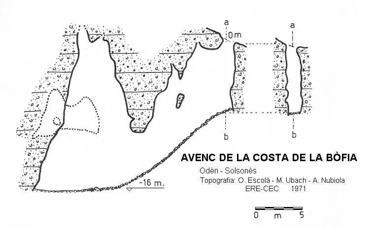
Espeleoindex · CC BY-NC 4.0, https://creativecommons.org/licenses/by-nc/4.0/ · Image © its author.
Description
Morphology
An entrance of just over a metre in diameter, of meagre dimensions of 1.05x0.50 metres, gives way, after descending a vertical of 8 metres, to a descending gallery that at its final part, in one of the walls, opens a window that communicates with a raised side chamber.
Progression
We will go down the path and once the bend is made we will continue along the ridge by an abandoned path that after a few metres turns 180º to the left, descending the slope of the forest with a steep gradient.
We will pass beside the small path that descends to the entrance of the avenc Montserrat Ubach and continue gliding across a gully and gradually gain height up to a ridge with a view of the channel where the avenc Montserrat Ubach is found.
We will continue, leaving a path to the right, later passing the head of a small torrent, with some stakes driven into the ground. We will descend by the next path to the right, quite abandoned and with a steep downward slope, until it turns left, here we will leave it. We will continue descending along the ridge without a path, among holm oaks, boxwoods, gorse, crossing three stony areas of cobbles without vegetation, gradually deviating towards the torrent on the right, until crossing it at a point where we will find stony ground on each slope, and a large rock on the right bank, of approximately one cubic metre. From here we will climb the right slope about 20 metres, entering the first pines of the forest, with some low cut branches, and we will find it among holm oak groves and boxwoods, very well hidden.
History
The first exploration was carried out by the ERE of the CE Catalunya in 1971.
User Comments (0)
No comments yet.
Be the first to share your experience!
Registered Explorations (0)
No explorations registered yet.
Register your visit to this cave!
Bibliography
- Borràs,J; Miñarro,J.M; Talavera,F.(1980).-”l'Urgell, el Solsonès, la Segarra i el Berguedà”. Catàleg Espeleològic de Catalunya (vol 5):1-233. Ed. Políglota. Barcelona.
- Valles, Jordi de (2008).-”Alt Urgell, Noguera, Pla d'Urgell, Segarra, Solsonès, Urgell”. Catàleg Espeleològic de Catalunya (2):1-384. EC Gràcia-FCE
Nearby caves


Source: Espeleoindex (espeleoindex.com), modified. CC BY-NC 4.0, https://creativecommons.org/licenses/by-nc/4.0/