

Horat Der Unhòla
A large karst depression and sinkhole in the Val d'Aran, with a cavity more than 200 m deep. It includes the Hilat Bernard Magos (T-2) and the Hilat era Ansa dera Caudèra, discovered in 2018.
EspeleoWorld
Horat Der Unhòla
A large karst depression and sinkhole in the Val d'Aran, with a cavity more than 200 m deep. It includes the Hilat Bernard Magos (T-2) and the Hilat era Ansa dera Caudèra, discovered in 2018.
Vielha e Mijaran · Val d'Aran
Sviluppo: 835 m · Profondità: 204 m
Scheda aggiornata
https://espeleoworld.com/it/c/horat-der-unhola
Le informazioni possono cambiare. Verifica sempre coordinate, accesso, meteo e condizioni della cavità prima di partire.
A large karst depression and sinkhole in the Val d'Aran, with a cavity more than 200 m deep. It includes the Hilat Bernard Magos (T-2) and the Hilat era Ansa dera Caudèra, discovered in 2018.
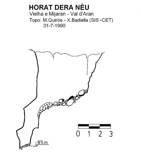
Topografia

Espeleoindex · CC BY-NC 4.0, https://creativecommons.org/licenses/by-nc/4.0/ · Immagine © del suo autore.
Foto
Espeleoindex · CC BY-NC 4.0, https://creativecommons.org/licenses/by-nc/4.0/ · Immagine © del suo autore.
Descrizione
Morfologia
The cavity originates in a large collapse doline 130 m in diameter (N-S axis) and 110 m in diameter (E-W axis) through which the small river (Arriu der Unhòla) that is born in the nearby Liat lake flows. On the NE side it is possible to descend without equipment despite the steep slope. The S side is formed by a vertical wall of 38 m of limestone rock, while the N zone, through which the river plunges, is of schists. Below the S wall, at the lowest point of the depression, the small river flows.
Within the large doline two cavities totally independent of each other have been explored: Hilat Bernard Magos (known since 1973 as T-2) and the Hilat era Ansa dera Caudèra, discovered and explored since 2018.
Hilat Bernard Magos or Traou T-2:
The entrance opening to the Hilat Bernard Magos opens in the E wall, at 2072 m altitude, a little more than 8 m above the lowest point of the doline, in the Cambro-Ordovician limestones. In summer, a cold air current comes out of the opening.
The cavity begins with a pit of 8 m hidden by a rock point and then descends through small downclimbs cut by very selective narrows (one in “S” and another in “V”) until reaching a hall 15 m high. From this hall, a crawlway between blocks ends in a chimney.
The attempts at digging have been considered very dangerous and have been abandoned
The lowest point is located 22 m below the entrance, at an altitude of 2050 m, that is, 14 m below the bottom of the doline
Hilat era Ansa dera Caudèra:
The entrance sector is found in an area of accumulation of large blocks leaning against the west wall of the doline, about 2 m of drop above the lowest point. This clastic accumulation had to be dug through a thickness of 3-4 m before reaching the base of the rock. In summer, the entrance presents a violent air current.
A few metres after the mouth and below a short vertical step, there is an inclined plane followed by a step “L'Air et les Gants” (P-6), very narrow and uncomfortable that has had to be widened as much as possible. At the bottom of this pit there is a long ledge formed by marble slabs with very sharp edges. The ceiling is a kind of chimney formed by enormous blocks fitted between each other. Through here one accesses the head of the “Puits Zorglub” (P-19), impressive for its dimensions and the beauty of its walls where magnificent folds of the rock can be observed, testimony of the ancient metamorphism and of the Hercynian orogeny. At its highest point a small unsurveyed gallery has been explored.
At the base of the “Puits Zorglub” begins a gallery with a slight slope and full of blocks. It continues a few metres to a downclimb (R-2) formed by blocks fitted on a thin slab in balance, the “Dalle du Chat”.
After a short ledge one reaches the “Petit Ressaut à Marie” (R-4), easy to downclimb.
Next, another flat zone where we turn left at a right angle and reach the top of an inclined plane that leads to the “Puits de la Dev' de Merde” (P-7) and at its base there is a “T” junction. To the right, an ascending tributary seems to communicate with the pit that is above the “Dalle du Chat”. To the left the air current of the entrance is recovered. This passage allows access to the head of the “Puits des Vasques” (P-8), of good dimensions and that is divided by the “Pont de Pierre”, ending in a long inclined plane where the “Grand Toboggan” begins, a beautiful gallery excavated in a forced conduit in the marble.
This gallery begins with a series of downclimbs (R-13, R-4, R-5, R-4 and R-7) easy to overcome without equipment. In the last one attention must be paid as it gives access to the head of the “Puits Bibi Fricotin” (P-8), where erosion has left the rock shining and all the colour nuances of the marble can be observed. At its base there is a large pothole 60 cm in diameter and 1 m deep and where a small river trout was found !. It is the “Salle de la Truite” followed by two short ramps before reaching the head of the “Puits Georges Jauzion”.
This pit, 22 m, is the most important of the cavity and stands out for its dimensions and beauty. With regular and polished walls, one would say it has been cut by a tunnel boring machine.
From here one follows the water before entering a beautiful gallery with four downclimbs (R-2, R-6, R-6 and R-8) and accessing the “Salle des Vibrations”. This hall presents large dimensions (20 m in diameter by 8 m in height) and is formed by a fault between the schists and the limestone. The floor, in a descending ramp of 30 to 40º, is full of enormous blocks coming from the collapse of an upper network still visible in the ceiling of the hall.
In this hall three continuations open. At the lowest point a downclimb (R-8) and a ramp conduit lead to a pit (P-8) that originates the “Salle de la Rotonde” where it connects with an inclined gallery, “Collecteur Lulú” followed by a short gallery that ends in a first sump, “Siphon Lulú”
From the central zone of the “Salle des Vibrations” there is another descending conduit that leads to the “Salle de la Rotonde”, but below this junction point, a 3 m downclimb allows entering a gallery that at its bottom reaches a second sump.
Before this point, a short gallery leads to the “Salle de l'Esculpture”, in the ceiling of which there is an inclined chimney that originates at the end of the “Salle des Vibrations”. At the end of the “Salle de l'Esculptura” a large chaos of blocks divides it in two. On the other side of the chaos a small conduit continues that leads to a small pit 1 m in diameter that is flooded from 5 m depth and represents the furthest point from the mouth of the system.
All this final sector of the cavity is constituted by a series of conduits that drain water all year, even during the low-water period. Some year of more hydrological activity it has been impossible to penetrate in the month of August.
(Exploration in progress by the Mundus Subterraneus collective)
Speleometry: The depth figure (- 204 m) and the development (835 m) are approximate since the explorers already state that the entire lower sector of the cavity is an exploration sketch.
Idrologia
Hydrology: All the water that penetrates in abundance through the large Unhòla doline circulates underground for some kilometres and through the dye tracings carried out appears at two important springs: Uelh de Sescorjada or Hónt dera Pila (1790 m a s l) and at the Hónt de Térme (1570 m a s l), which represents a minimum drop of the system of 530 m.
The other important cavity of the zone, Horat der Uelh deth Tor, also has a hydrological relation with the system.
Altri dettagli
Toponymy: Although when the main route was discovered it was named Trou des Grenoblois, it was soon changed to Réseau de l'Anse du Chaudron which, translated into Aranese, became Hilat der Ansa dera Caudèra. In Catalan: Xarxa de la Nansa de la Caldera. We do not know the origin and meaning of this denomination.
Storia
The large depression, also called l'Embut de Liat, is a geographical feature known since remote times by shepherds, hunters and certainly by the workers of the Liat mines since the 19th century. Despite this it does not appear cited in any of the old speleological catalogues.
In July 1930 the Union Pyrénénne Électrique (UPE) makes a first dye tracing of the waters that penetrate through Unhòla trusting that they would come out at the Fontaine d'Ardan, near Bentaillou (Ariège, FR) but the result is negative. Nevertheless those of the UPE are not convinced and entrust Norbert Casteret with a new test and thus it is that Casteret on 4 July 1933 at 20 h injects fluorescein at the head of the cascade of the Horat and on 6 July at 9.30 h it reappears at the Hónt dera Pila (Sescorjada).
This relation could already be established when, at the beginning of the 1970s, engineers of FECSA made a dye tracing with fluorescein. Another dye tracing was carried out by the Servei Geològic de Catalunya on 8 October 1990, pouring into the Horat der Unhòla 10 kg. of fluorescein, giving positive at Sescorjada on 14 October; two days later it was also detected positive at the Hònt deth Terme, some 3 km. to the west of Sescorjada.
But speleologically it remained unpublished until August 1973, a Franco-Belgian expedition, commanded by Bernard Magos, explores it together with other cavities of the Liat zone. They call it “la Grande Dolina” and the pit that opens at its bottom they catalogue as T-2 (now ·Hilat Bernard Magos).
In the summer of 1975 it receives a new visit by members of two speleological groups of Lyon.
On 28 August 1978, within a new campaign in the zone, this time by the Groupe Spéléologique des Pyrénées (Toulouse de Llenguadoc), they visit it again and make a new survey, a little (not much) more accurate than the one made by the first explorers.
The summer of 1990 it is also visited by the colleagues of the SIS – CE Terrassa during their first campaign at the Uelh deth Tur.
It is not until the summer of 2018 that, a collective of French speleologists, under the command of Yves Besset, very linked to the zone and a good connoisseur of the terrain since the 1978 campaign, return to Liat. It is in these days that members of the expedition sense that under the blocks of the bottom of the doline there may be some continuation. And their intuition does not fail, after removing a good pile of blocks they reach a narrow vertical conduit that will have to be dug but that has a good appearance.
In the summer of 2019 they return with the main objective of continuing the digging to facilitate the passage and they manage to reach the “Salle des Vibrations” and the first conduits that come out of it, which they partially explore in August 2020, in the midst of the Covid pandemic, and reach the first two sumps. The following year, 2021, the campaign is practically sterile due to the high water levels in all the conduits. Finally it is in August 2022 when they can access again and partially explore some chimneys that feed the hydrological circulation of the entire lower level and also reach a flooded pit located at the same level as the two known sumps.
In early June 2023 Yves Besset died at 78 years of age, mother soul of the campaigns and his colleagues decided to suspend the summer campaign. It remains to finish reviewing some conduits of the final zone and to survey all this sector, since for the moment only an exploration sketch is available.
Commenti degli utenti (0)
Nessun commento ancora.
Sii il primo a condividere la tua esperienza!
Esplorazioni registrate (0)
Nessuna esplorazione registrata.
Registra la tua visita a questa grotta!
Bibliografia
- AA (1974).- “Expedition Spéléologique franco-belge dans les Pyrénées espagnoles” Rapport d'expedition – Canarss (4): Federation Spéléologique de Belgique.
- Besset, Y. (1977).- “Spéléologie au Val d'Aran (Espagne)” Ouarnède (9): 57-76. GS des Pyrénées. Toulouse.
- Cardona, F. (1989).- Grans cavitats de Catalunya. Vol. 1, 198 pp. EC de Gràcia, Barcelona
- Monterde,M: Cervelló, JM.; Ramoneda,J.; Ramoneda,Jp.; Morin, JP.; López, JM.; Besset, Y.; Derroja, C.;Chailloux, D.; Freixes, A. (2023).- Geodiversitat i recursos hídrics en els carsts aranesos: sistemes d'Uelhs deth Joeu, Lastoar, Tèrme-Pila i Aigüèira. Iª Escola Aranesa d'Hidrologia del Carst (juny 2023): 50 pp. (document digital).
- Mundus Subterraneus (2020).- Memoire du camp Val d'Aran – 2019 : 58 pp. (document digital).
- Mundus Subterraneus (2021).- Memoire du camp Val d'Aran – 2020 : 110 pp (document digital)
- Quirós, M.; Galí, D.; Badiella, X.; Badiella, E. (1992).- “Uelh d'eth Tur” SIS (12): 73-84 / Arxiu del Centre Excursionista de Terrassa (75): 209-220. CE Terrassa.
- SIE – CEA (2003).- “Uelh de Sescorjada, - 86 m.” EspeleoCat (1): 37-40. Federació Catalana d'Espeleologia. Barcelona.
Grotte vicine




Fonte: Espeleoindex (espeleoindex.com), modificato. CC BY-NC 4.0, https://creativecommons.org/licenses/by-nc/4.0/