
Graller d'Estrulls
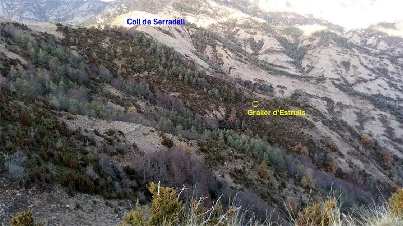
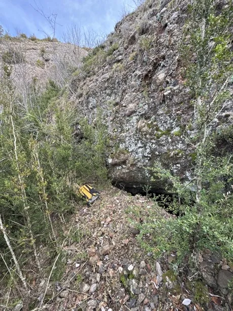
A 24 m deep pit rediscovered in the Serra de Lleràs, at 1493 m altitude, explored in 1962 and located again on 6 December 2019.
EspeleoWorld
Graller d'Estrulls
A 24 m deep pit rediscovered in the Serra de Lleràs, at 1493 m altitude, explored in 1962 and located again on 6 December 2019.
Conca de Dalt · Pallars Jussà
Sviluppo: 40 m · Profondità: 24 m
Scheda aggiornata
https://espeleoworld.com/it/c/graller-d-estrulls
Le informazioni possono cambiare. Verifica sempre coordinate, accesso, meteo e condizioni della cavità prima di partire.
A 24 m deep pit rediscovered in the Serra de Lleràs, at 1493 m altitude, explored in 1962 and located again on 6 December 2019.
Topografia
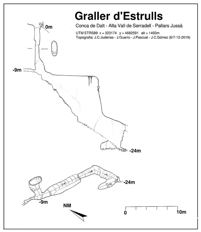
Espeleoindex · CC BY-NC 4.0, https://creativecommons.org/licenses/by-nc/4.0/ · Immagine © del suo autore.
Foto
Espeleoindex · CC BY-NC 4.0, https://creativecommons.org/licenses/by-nc/4.0/ · Immagine © del suo autore.
Descrizione
Morfologia
An entrance pit of about 9 m depth leads to the start of a steep ramp, which makes a 90º turn towards the SE, with a very high ceiling. The end of the ramp is at -24 m depth, where the gallery ends completely filled with sediments. At this point, a short climb leads to a narrow fissure, impenetrable due to a parietal flowstone.
Progressione
An entrance pit of about 9 m depth; a steep ramp with a 90º turn towards the SE and a very high ceiling; the end of the ramp at -24 m; a short climb to a narrow fissure, impenetrable due to a parietal flowstone.
Storia
Cavity explored in 1962 by members of the G.E.Badalona, who initially assign it a depth of -38 m (Memòria GEB 1962) and later cite it with a depth of -35 m in the publication of the summary prior to the 1er Campament d'Espeleòlegs a la Vall de Serradell, where they place the cavity approximately on a map of ridges, between the coll de Serradell and the Pui de Lleràs at an altitude of about 1450 m.
No further news of any other exploration is received and the pothole remains forgotten and unlocatable for almost 60 years, until, in an attempt to search for new cavities that would allow access to the unexplored parts of the Cuberes-Rivert system, several cavers from Barcelona and from the SAM de Tremp (J.C.Juderias, J.Pascual, J.Viñuales, J.Guarro) begin to search the bibliography and realise that this Graller d'Estrulls must be located in the upper zone of the Pui de Lleràs massif, between the Cova Cuberes and the Font de Rivert, and from the end of 2018 to the end of 2019 they undertake various days of prospecting without managing to locate the cavity.
Finally, on 6 December 2019, J.C.Juderias and J.Guarro, with the help of LIDAR relief cartography, locate and survey the cavity, and the next day J.Pascual and J.C.Gómez (SAM de Tremp) return to carry out a climb and verify that the cavity does not continue.
Note biospeleologiche
At the bottom of the cavity, a skeleton, probably of a wild boar, has been found.
Commenti degli utenti (0)
Nessun commento ancora.
Sii il primo a condividere la tua esperienza!
Esplorazioni registrate (0)
Nessuna esplorazione registrata.
Registra la tua visita a questa grotta!
Bibliografia
- G.E.B. (1962).- Memoria Espeleológica 1962. 24 pp. s/numerar. Grup d'Espeleologia de Badalona.
- C.R.E.S. (1966) - “Resumen de las exploraciones espeleológicas efectuadas en el valle de Serradell, antes del campamento”. 1er Campamento Regional de Espeleólogos. 19 pp. s/numerar. GE Badalona.
- Borràs, J.; Miñarro, J.M.; Talavera, F. (1979) - Catàleg Espeleològic de Catalunya Vol.3 – Ed. Políglota. Barcelona.
- Valles, J. de (2008) - Catàleg Espeleològic de Catalunya – Vol.1: 319 pp. Espeleo Club de Gràcia – Federació Catalana d'Espeleologia. Barcelona
- Dades facilitades per Josep Guarro. Fotografies exteriors de Joan Carles Juderias. Fotografies interiors de Jordi Pascual i J.C. Gómez (SAM de Tremp).
Grotte vicine


Fonte: Espeleoindex (espeleoindex.com), modificato. CC BY-NC 4.0, https://creativecommons.org/licenses/by-nc/4.0/