
Forat de les Olles
A 60-metre-deep pit in Pedraforca (Saldes), with a route of 268 metres and a total elevation change of +8/-52 metres.
EspeleoWorld
Forat de les Olles
A 60-metre-deep pit in Pedraforca (Saldes), with a route of 268 metres and a total elevation change of +8/-52 metres.
Saldes · Berguedà
Sviluppo: 268 m · Profondità: 60 m
Scheda aggiornata
https://espeleoworld.com/it/c/forat-de-les-olles
Le informazioni possono cambiare. Verifica sempre coordinate, accesso, meteo e condizioni della cavità prima di partire.
A 60-metre-deep pit in Pedraforca (Saldes), with a route of 268 metres and a total elevation change of +8/-52 metres.
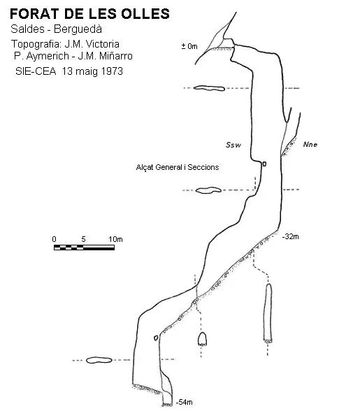
Topografia
Espeleoindex · CC BY-NC 4.0, https://creativecommons.org/licenses/by-nc/4.0/ · Immagine © del suo autore.
Foto
Espeleoindex · CC BY-NC 4.0, https://creativecommons.org/licenses/by-nc/4.0/ · Immagine © del suo autore.
Descrizione
Morfologia
The best-known old part of the cavity begins with a short gallery that brings us to an extremely narrow passage, behind which the first drop of about 3 metres of elevation change opens up. From this point, the profile of the cavity extends towards the N, and we must descend a fairly irregular pit with some ledges until reaching -32 metres of depth. At this point a gallery begins with a steep slope and in a direction completely opposite to the one we had been following; at the end of the slope we find a 9-metre pit and at its base a small drop that places us at the maximum elevation change of the cavity of -52 metres.
The new route begins just past the entrance, where we find on the other side of the pit and in a N direction a ascending meander that brings us up to the +8 metre level, continuing along a downward-sloping ramp covered with very slippery white mud. Next we find the pou de la Il·lusió (-20 m) of about 3 to 4 metres in diameter that leads us to a fissure, which leads to a small chamber. The direction changes towards the W, as does the morphology of the cavity; after the chamber we find a small step where a meandering gallery begins, de les Xemeneies. We will encounter in this gallery various chimneys, the floor covered with blocks and some sections with water. The ceiling of the gallery gradually lowers and we have to crawl for about 14 metres until reaching the dels Rat-penats chamber where this new section of the cavity ends, which reaches the same depth as the previously known one. The total elevation change of the cavity is 60 metres (+8/-52), and the route is 268 metres.
Idrologia
At the base of the small chamber there is an impassable water drainage point, where in rainy periods the water plunges in a cascade coming from the infiltrations it receives from the galleries described below. At the beginning of the de les Xemeneies gallery we find another small waterfall.
Progressione
The downward-sloping ramp is covered with very slippery white mud where a safety rope must be installed.
Storia
The first exploration took place during Holy Week (1 to 6 April) of 1953 by members of the Centre Excursionista de la Comarca de Bages (Manresa), during a mountain camp organised by the entity at Prat de Reo (Saldes). The explorers were the initial group of the speleology section (EDES) created that same year.
On 13 May 1973 the SIE of the CEA carried out the first survey of the cavity.
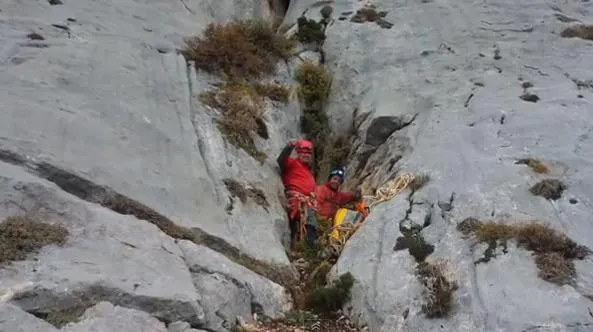
On 10 November 2012 members of the GE Badalona accessed the upper part of the via d'escalada Bages with the intention of checking and clearing a possible cavity. As the clearing was unsuccessful, they decided to access the Forat de les Olles located in the lower part of this route. Just upon entering, they observe an unknown meander, in a N direction, which opened up passing above the known pit; they decide to explore it and access a new route of this cavity. The GEB returns again on 13 May 2013 to finish exploring the cavity and carry out a new survey.
Commenti degli utenti (0)
Nessun commento ancora.
Sii il primo a condividere la tua esperienza!
Esplorazioni registrate (0)
Nessuna esplorazione registrata.
Registra la tua visita a questa grotta!
Bibliografia
- Miñarro,J.M.(1974).- “Apuntes para el conocimiento espeleológico del Pedraforca” Espeleosie (15):23-54. SIE-CE Àliga. Barcelona.
- Rubiralta, F. (1953).- "Espeleologia: El Forat de les Olles" Circular (80): 1-2 Centre Excursionista Comarca de Bages. Manresa.
- Borràs,J; Miñarro,J.M.; Talavera,F.(1980).-Catàleg Espeleològic de Catalunya (vol.5): 19-126.(l'Urgell-el Solsonès-la Segarra i el Berguedà). ed. Políglota. Barcelona.
- Coordenades, topografia, fotos i dades, extretes del web del GE Badalona (www.geb.cat) post del dia 25/7/2014.
Grotte vicine


Fonte: Espeleoindex (espeleoindex.com), modificato. CC BY-NC 4.0, https://creativecommons.org/licenses/by-nc/4.0/