

Cova de les Grioteres
A cave with a reticulate layout and a surveyed length of 323 m in Vilanova de Sau (Osona), with seven entrances, labyrinthine galleries and archaeological remains from the Neolithic to the Middle Ages.
EspeleoWorld
Cova de les Grioteres
A cave with a reticulate layout and a surveyed length of 323 m in Vilanova de Sau (Osona), with seven entrances, labyrinthine galleries and archaeological remains from the Neolithic to the Middle Ages.
Vilanova de Sau · Osona
Sviluppo: 323 m
Scheda aggiornata
https://espeleoworld.com/it/c/cova-de-les-grioteres
Le informazioni possono cambiare. Verifica sempre coordinate, accesso, meteo e condizioni della cavità prima di partire.
A cave with a reticulate layout and a surveyed length of 323 m in Vilanova de Sau (Osona), with seven entrances, labyrinthine galleries and archaeological remains from the Neolithic to the Middle Ages.
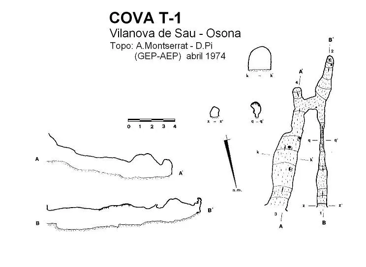
Topografia

Espeleoindex · CC BY-NC 4.0, https://creativecommons.org/licenses/by-nc/4.0/ · Immagine © del suo autore.
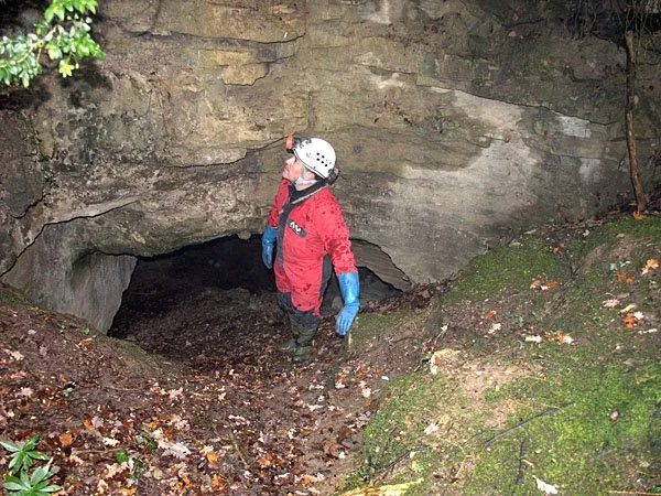
Foto
Espeleoindex · CC BY-NC 4.0, https://creativecommons.org/licenses/by-nc/4.0/ · Immagine © del suo autore.
Descrizione
Morfologia
Of the seven entrances the cave has, only two are easy to access, since the other five hang in the cliff. All these entrances are connected inside by a series of galleries with a reticulate structure, which gives the whole a labyrinthine appearance. These galleries, found in the first metres, gradually lose width until they become totally obstructed by sediments. Only two of them maintain continuity towards the interior of the limestone mass. At the entrance marked as no. 5 begins the longest gallery, which, after 22 metres of passage, suddenly narrows forming a small chamber from which two galleries set off. The one going to the left (according to the direction of entry) is of medium form and as one advances it gains height and loses width. This gallery ends in two very narrow branches where some clastic process can be observed. Returning to the small chamber mentioned above, if one follows the right-hand gallery the ceiling height is very low for the first metres and then quickly gains height. This gallery descends slightly towards a meander that is currently obstructed and beside which there is a new passage about 2 metres long that must be negotiated by crawling, to emerge into another meander where the gallery again gains height and becomes slightly ascending. One then reaches a small hall that breaks the continuity of the gallery and which is found again at the other end of it, where it continues through a very low-ceilinged conduit that leads to another gallery of the same width dimensions, but with a greater development in height. This gallery, which extends for about 20 metres, ends in a small widening where an old descending conduit can be observed, currently filled by sediments. The other gallery to highlight, marked on the survey with no. 2, is, in its first 12 metres, quite wide, then taking a more or less semicircular form until reaching a passage with a relatively low ceiling that leads into a fairly high gallery which, in its final stretch, descends through a narrow passage towards a terminal conduit of reduced dimensions, which ends about 5 metres on, being totally obstructed by sediments. In all of the initial galleries one can observe the “emptying” of sediments that has been carried out for archaeological purposes. The whole of all the galleries presents a surveyed length of 323 metres; we do not know the cave's vertical extent as it is not provided by the authors of the survey.
Idrologia
It is a typical spring excavated in the so-called calcàries sorrenques de Tavertet and to whose genesis the subterranean course that currently flows about 15 metres below the level of the cave has contributed.
Storia
Around 1959, Mr. Martí Cassany, of Vic, learned that during the war (1936-39) a group of people had hidden in some caves beneath a cliff in the Sau area. He was able to speak with one of them and, besides giving him the location, he explained that the ground was full of the “olles d'en Serrallonga”. Between 1959 and 1960, with the participation of collaborating members of the Museu Episcopal de Vic, the first archaeological campaign of this group of cavities was carried out. It should be said that in its interior remains have been located ranging from the Neolithic to the Middle Ages. It is not until the middle of 1973 that, through a friend of the Unió Excursionista de Vic, members of the GEP of the AE Pedraforca (Barcelona) learn of the cave, proceeding to its complete exploration and study, which was published in the journal Speleon in 1974. It was from then on that it became known in the speleological bibliography. Toponymy: The toponym Grioteres is possibly a derivation of Guilloteres (cau de guilles).
Commenti degli utenti (0)
Nessun commento ancora.
Sii il primo a condividere la tua esperienza!
Esplorazioni registrate (0)
Nessuna esplorazione registrata.
Registra la tua visita a questa grotta!
Bibliografia
- Castany i Llussà, Josep (1983 ?).- Les coves de les Grioteres (Vilanova de Sau, Osona). (pdf) Centre d'Informació i Documentació del Patrimoni Cultural. Generalitat de Catalunya.
- Montserrat, A.; Pi, D. (1974).- “El karst del Turó de Terrades. La Cova de les Grioteres”. Speleon (21): 31-70. Centre Excursionista de Catalunya. Barcelona.
- Coordenades, fotografies i altres dades extretes del blog: Espeleobloc (post del 21-10-2010)
Grotte vicine




Fonte: Espeleoindex (espeleoindex.com), modificato. CC BY-NC 4.0, https://creativecommons.org/licenses/by-nc/4.0/