
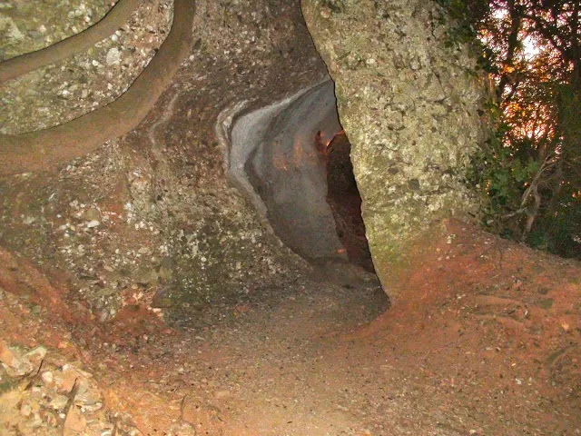
Balma de la Llosa
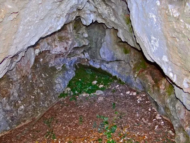
Small tunnel on the northern slope of the Mola de Sant Llorenç, formed by a large slab of rock fallen from the cliff and leaning against the wall, known to hikers on the route from the Mola to the Morral del Drac.
EspeleoWorld
Balma de la Llosa
Small tunnel on the northern slope of the Mola de Sant Llorenç, formed by a large slab of rock fallen from the cliff and leaning against the wall, known to hikers on the route from the Mola to the Morral del Drac.
Matadepera · Vallès Occidental
Sviluppo: 10 m
Scheda aggiornata
https://espeleoworld.com/it/c/balma-de-la-llosa
Le informazioni possono cambiare. Verifica sempre coordinate, accesso, meteo e condizioni della cavità prima di partire.
Small tunnel on the northern slope of the Mola de Sant Llorenç, formed by a large slab of rock fallen from the cliff and leaning against the wall, known to hikers on the route from the Mola to the Morral del Drac.
Foto

Espeleoindex · CC BY-NC 4.0, https://creativecommons.org/licenses/by-nc/4.0/ · Immagine © del suo autore.
Descrizione
Morfologia
It is nothing more than a short tunnel caused by a large slab of rock fallen from the cliff and leaning against the wall.
Altri dettagli
No survey is available.
Storia
Very well known to hikers who follow this route. In the guide to Sant Llorenç del Munt, published in 1935 by the Centre Excursionista de Terrassa, it is already mentioned on the route from the Mola to the Morral del Drac, saying: “where one finds a detached rock that, like a sloping slab, forms a capricious open cave,”.
For some time there has been a certain confusion between this cavity and the so-called Cova de la Sargantana, located a little further to the S. Logically, this one must be the Balma de la Llosa (because of the large slab that forms it) and the other the Cova de la Sargantana, as it is a narrow fissure, with no resemblance to a balma. The error seems to originate in the Editorial Alpina map, 1972 edition, where it is catalogued as Cova de la Sargantana, adding that it is a large detached block beside the path. Later, in 1988, the CE Terrassa published the map of Sant Llorenç i Serra de l'Obac on which the Balma de la Llosa appears, located a little further S than it actually is. The Cova de la Sargantana does not appear.
But the maps (Alpina and ICGC), the wikilocs of the area and some experts on Sant Llorenç say quite the opposite and swap the names.
Commenti degli utenti (0)
Nessun commento ancora.
Sii il primo a condividere la tua esperienza!
Esplorazioni registrate (0)
Nessuna esplorazione registrata.
Registra la tua visita a questa grotta!
Bibliografia
- Fotografies extretes del blog: trailsantllorenc.blogspot (de Lluís R. Hernández, Matadepera)
Grotte vicine
Cova de l'Alzina
0.0 km · N
Matadepera (Vallès Occidental)
2 foto
Cova de la Sargantana
0.1 km · S
Matadepera (Vallès Occidental)
1 topo.2 foto
Cova de la Canal dels Boixos
0.1 km · N
Matadepera (Vallès Occidental)
1 foto
Cova de la Canal dels Bombers
0.2 km · N
Matadepera (Vallès Occidental)
1 foto
Fonte: Espeleoindex (espeleoindex.com), modificato. CC BY-NC 4.0, https://creativecommons.org/licenses/by-nc/4.0/