
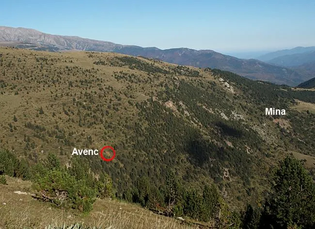
Avenc de les Fonts del Ritort
A 12 m pit in a collapse doline on the S slope of the Costabona (Ripollès), with access from Molló via the C-38 and Espinavell.
EspeleoWorld
Avenc de les Fonts del Ritort
A 12 m pit in a collapse doline on the S slope of the Costabona (Ripollès), with access from Molló via the C-38 and Espinavell.
Molló · Ripollès
Sviluppo: 15 m · Profondità: 12 m
Scheda aggiornata
https://espeleoworld.com/it/c/avenc-de-les-fonts-del-ritort
Le informazioni possono cambiare. Verifica sempre coordinate, accesso, meteo e condizioni della cavità prima di partire.
A 12 m pit in a collapse doline on the S slope of the Costabona (Ripollès), with access from Molló via the C-38 and Espinavell.
Topografia
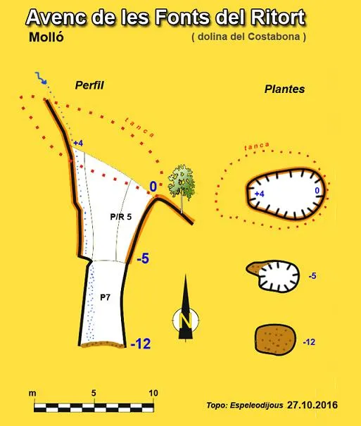
Espeleoindex · CC BY-NC 4.0, https://creativecommons.org/licenses/by-nc/4.0/ · Immagine © del suo autore.
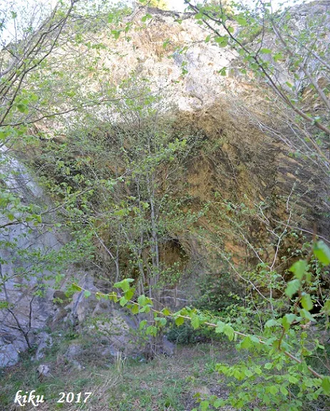
Foto
Espeleoindex · CC BY-NC 4.0, https://creativecommons.org/licenses/by-nc/4.0/ · Immagine © del suo autore.
Descrizione
Morfologia
Inside a funnel about 8 metres in diameter, originated by a collapse doline (apparently recent), one enters a single pit with a drop of 12 metres (from the lower lip), normally dripping and with the bottom completely choked by the materials that come loose from the dismantling of the outer doline. The first metres of descent are somewhat subvertical with very earthy walls that slip away. This effect has caused the pit to have lost about 8 metres of depth compared with the first exploration (2011). It would not be surprising if in a relatively short time the cavity were to become completely choked.
The whole relief of this sector is covered by a thick soil, and these terrigenous materials hide the underlying rocks. As we see on the ICGC geological map at 1:50000 of the sector, the cavity is located in Palaeozoic materials, in a set of Cambro-Ordovician metamorphic rocks (limestones, dolomites and marbles), close to the schists and some skarn contact facies.
Idrologia
At the bottom there is a small conduit through which the water trickles.
Progressione
The first metres of descent are somewhat subvertical with very earthy walls that slip away.
Storia
The first news of the cavity was provided by Jaume Serrate, one of the founders of the SIS – CET, who on 1 May 2011 located the cavity and immediately notified Salvador Vives. The following Sunday, members of the SIS made a first attempt at descending but brought too little rope and did not reach the bottom. The following week they returned and completed the exploration. They assigned it a depth of 24 metres (from the upper lip) and at the bottom there is a small conduit through which the water trickles.
Five years later, members of the Entente Spéléologique du Roussillon had information about the presence of the doline and on 11 September 2016 went up to take a look. They explored it and calculated that the maximum depth reaches 15 metres. They named it Doline du Costabonne.
Shortly afterwards, on 27 October 2016, members of the espeleodijous group visited the pit again and produced a new survey. At that time the pit was 12 metres deep and the infilling that the bottom of the pit had undergone was confirmed.
Commenti degli utenti (0)
Nessun commento ancora.
Sii il primo a condividere la tua esperienza!
Esplorazioni registrate (0)
Nessuna esplorazione registrata.
Registra la tua visita a questa grotta!
Bibliografia
- Dades, coordenades, topografia i fotografies extretes del blog: espeleobloc.blogspot. Apunt del 7-11-2016.
- Altres dades d'interès a: sisdelcet.blogspot. Apunt del 1-8-2011 (SIS - CET) i esr.figarola.fr (Entente Spéléologique du Roussillon). Apunt del 14-11-2016
Grotte vicine


Fonte: Espeleoindex (espeleoindex.com), modificato. CC BY-NC 4.0, https://creativecommons.org/licenses/by-nc/4.0/