
Avenc d'Enconills
A 40-metre-deep pit in Torà, explored in 1968, with a first inclined shaft of -11 metres and galleries that end at -40 metres.
EspeleoWorld
Avenc d'Enconills
A 40-metre-deep pit in Torà, explored in 1968, with a first inclined shaft of -11 metres and galleries that end at -40 metres.
Torà · Solsonès
Sviluppo: 128 m · Profondità: 40 m
Scheda aggiornata
https://espeleoworld.com/it/c/avenc-d-enconills
Le informazioni possono cambiare. Verifica sempre coordinate, accesso, meteo e condizioni della cavità prima di partire.
A 40-metre-deep pit in Torà, explored in 1968, with a first inclined shaft of -11 metres and galleries that end at -40 metres.
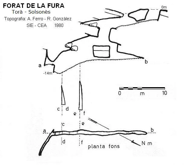
Topografia
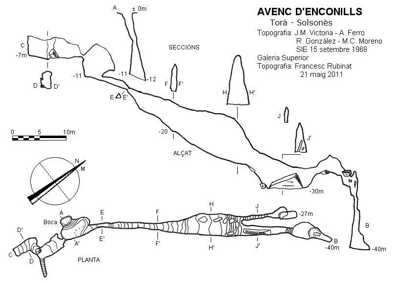
Espeleoindex · CC BY-NC 4.0, https://creativecommons.org/licenses/by-nc/4.0/ · Immagine © del suo autore.
Foto
Espeleoindex · CC BY-NC 4.0, https://creativecommons.org/licenses/by-nc/4.0/ · Immagine © del suo autore.
Descrizione
Morfologia
A first inclined shaft of -11 metres places us on a wide base; on the S side and at about 3 metres height an opening 0.5 metres in diameter gives access to a wide gallery 15 metres long, where halfway along we find a short descending gallery.
Back at the base of the entrance shaft, on the NE side it connects with a descending gallery that gradually widens until a chamber, where it divides into two parallel galleries. The more northerly branch has an ascending route of about 10 metres and ends in a small pothole at -27 metres depth, while the more easterly gallery drops abruptly 3 metres to a new elongated small chamber divided by a large block; on the other side the 3 metres must be climbed again, where we find some steps until reaching the last vertical of -10 metres, the cavity ending at -40 metres depth.
Storia
The first exploration was carried out on 15 September 1968 by the SIE of the CEA.
In 1980 members of the Espeleo Club de Gràcia made a new survey in which they included an upper gallery in the entrance shaft; this survey was not published until 2008 in the Catàleg Espeleològic de Catalunya. In 2011 members of the SIE.CEA and of the ERE-CEC made a survey revision in which they also included this upper gallery.
Toponymy:
The cavity in the area is known by the name Enconills since it is near the torrent d'Enconills; we suppose that the name d'en Conills is due to an erroneous phonetic interpretation.
Commenti degli utenti (0)
Nessun commento ancora.
Sii il primo a condividere la tua esperienza!
Esplorazioni registrate (0)
Nessuna esplorazione registrata.
Registra la tua visita a questa grotta!
Bibliografia
- Ferro i Guitart, Antonio.(1972).-“Avance al catastro del karst en yesos de la cuenca del río Llobregós”. EspeleSie (11):55-73.SIE-CE Àliga. Barcelona.
- Ferro i Guitart, Antonio.(1970).-“L'Avenc d'en Conills”. EspeleSie (7):31-35.SIE-CE Àliga. Barcelona.
- Borràs,J. ;Miñarro,JM. ;Talavera,F. (1980).-Catàleg Espeleològic de Catalunya. (Vol.5):211-227.(l'Urgell, el Solsonès, la Segarra i el Berguedà). Ed. Políglota. Barcelona.
- Valles, Jordi de (2008).-”Alt Urgell, Noguera, Pla d'Urgell, Segarra, Solsonès, Urgell”. Catàleg Espeleològic de Catalunya (vol.2):1-384. EC.Gràcia/Federació Catalana Espeleologia.
- Coordenades, situació, revisió topogràfica i fotografies facilitades per Antoni Ferro (SIE-CEA) Arcadia Cabanas i Francesc Rubinat (ERE-CEC) maig de 2011.
Grotte vicine


Fonte: Espeleoindex (espeleoindex.com), modificato. CC BY-NC 4.0, https://creativecommons.org/licenses/by-nc/4.0/