
Bòfia de Sant Jaume
Interessant cavitat de 479 m. de recorregut al Berguedà.
EspeleoWorld
Bòfia de Sant Jaume
Interessant cavitat de 479 m. de recorregut al Berguedà.
Navès · Solsonès
Length: 479 m · Depth: 37 m
Updated record
https://espeleoworld.com/en/c/bofia-de-sant-jaume
Information can change. Always verify coordinates, access, weather, and cave conditions before setting out.
A 479 m-long cave in the Berguedà, known since ancient times, with an archaeological site and successive surveys.
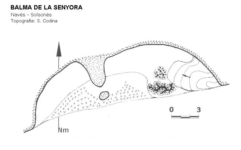
Topographic
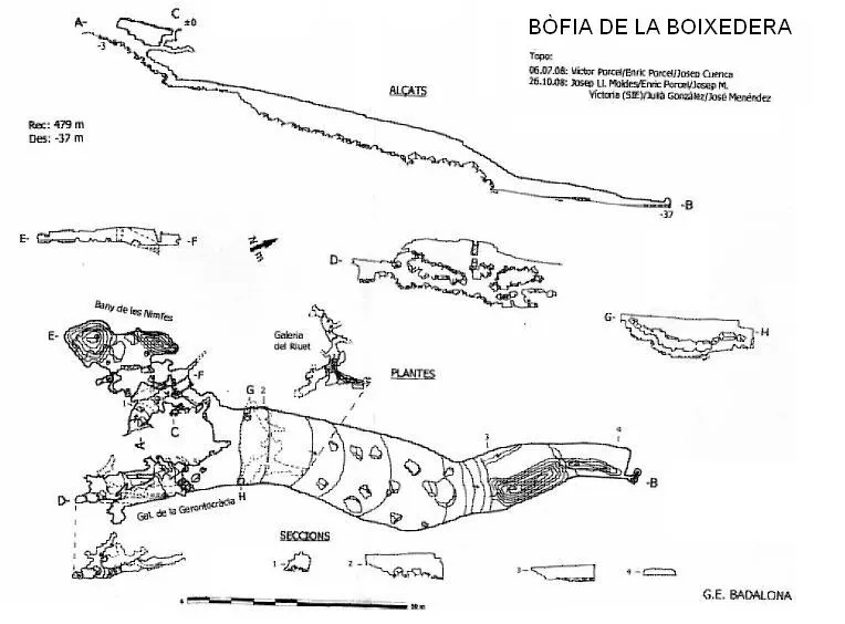
Espeleoindex · CC BY-NC 4.0, https://creativecommons.org/licenses/by-nc/4.0/ · Image © its author.
Photos
Espeleoindex · CC BY-NC 4.0, https://creativecommons.org/licenses/by-nc/4.0/ · Image © its author.
Description
Morphology
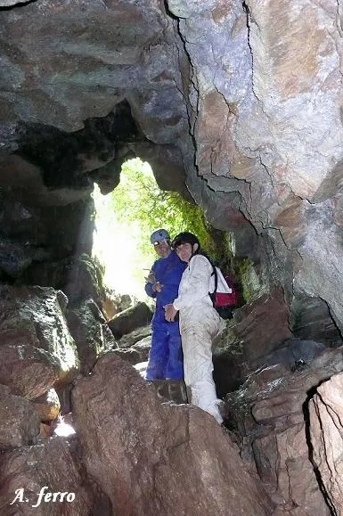
On a small esplanade the mouth of the shaft opens and a few metres further on there is a second mouth of much smaller dimensions. Entering through the main mouth gives access to a corridor about 20 metres long with an inclination of about 25º, entirely covered by large blocks; a few metres in, on the right-hand wall there is an ascending conduit that connects with the small mouth. Continuing along the main gallery and leaving a branch, the corridor narrows until reaching a height of 0.60 metres and after 5 metres gives access to a large gallery of about 40x20x5 metres (Sala d'Honor). At the end of this chamber and separated by a large clastic accumulation there is another gallery of smaller dimensions (Plaça de les Bruixes). The ceiling descends to the floor and at its end there is a narrow conduit, penetrable for very few metres, through which the water is lost and which represents the deepest point of the cave (level – 37).
Shortly after entering the Sala d'Honor and below the accumulation of large blocks, a small conduit develops (Galeria del riuet) which crosses the large gallery across its entire width. When the entrance corridor opens into the Sala d'Honor, on the right (S) a gallery develops (Galeria de la Gerontocràcia) divided into different conduits by the accumulation of blocks, presenting different levels.
This cave is located in the contact zone of the limestone with the conglomerates that cover them, presenting an inclination of about 15º. These materials have intercalations of brownish sandy marl.
Speleothems
The floor of the Plaça de les Bruixes is covered by a stalagmitic crust with the presence of a multitude of microgours and some of larger dimensions, normally full of water.
Hydrology
The Plaça de les Bruixes is temporarily traversed by a small watercourse. Among the blocks at the base of the Galeria del riuet is where the water that runs through the cave during periods of hydrological activity emerges.
Progression
Returning to the branch we left in the entrance corridor, one descends a 1.50 metre drop and after passing under a block, one reaches a small chamber (El bany de la princesa). By an ascending ramp one reaches the end point of these small lower galleries at the place called Les Campanes.
History
Cave known since time immemorial and visited since ancient times by the people of the region. Mentioned in the old catalogues of Madoz (1845-50), Puig y Larraz (1896), Font (1897) and Faura (1909) as La Bòfia (Montmajor). In the guide to the Catalan Pyrenees by C.A. Torras (1905) on the Berguedà, Mn. Bonaventura Ribera already gives a complete description, although he speaks of many fantasies.
Joan Serra Vilaró, ecclesiastic, historian, archaeologist and from 1906 director of the Museu Diocesà de Solsona, had visited the shaft at the beginning of the 20th century and around 1911 began to excavate the bones he had found inside. In May 1918 he returned and in the company of three friends of his (Bonet, Falguera and Puig), architecture students, they produced the first survey that we know of. During these days he proceeded to excavate at a site that, according to him, had been badly damaged by the people who entered to take away skulls. He extracted 19 human skulls and the same number of dog skulls, all of the same breed.
On 6 May 1934 a large group of members of the Club Muntanyenc Barcelonès made a complete visit, study and survey which was published in volume II of Sota Terra. They do not specify the total length of the cave.
In 1978, the SIE del CEA, in one of the many visits this group has made to the cave, produced a new survey, assigning it a length of only 215 metres, which is quite insufficient with respect to the total length that can be travelled through all the conduits of the cave.
During 2008, members of GE Badalona made a new survey, very meticulous and adding up all the penetrable secondary conduits, some of them never reflected in the previous surveys, with which they calculate a total length of 479 metres. Nevertheless they consider that the most correct name of the cave should be Bòfia de la Boixedera (the Espeleoindex team has decided to keep as the main name the one that has been applied to it for more than 70 years and by which it is known to the great majority of speleologists)
User Comments (0)
No comments yet.
Be the first to share your experience!
Registered Explorations (0)
No explorations registered yet.
Register your visit to this cave!
Bibliography
- Borràs, J.; Miñarro, JM.; Talavera, F. (1980).- Catàleg Espeleològic de Catalunya. (l'Urgell, el Solsonès, la Segarra i el Berguedà). Vol. 5: 234 pp. Políglota. Barcelona.
- Semir, R. de (1935).- “Bòfia de Sant Jaume” Sota Terra II : 37-48. Club Muntanyenc Barcelonès. Barcelona.
- Serra Vilaró, Joan (1966).- “Exploraciones arqueológicas en el Solsonés entre 1915 y 1923” Ampurias (28): 191-200
- SIE (1978).- “Nota sobre dues cavitats localitzades al límit del Solsonès i el Berguedà” EspeleoSie (22): 41-46. SIE – CE Àliga. Barcelona.
- Valles, J. de (2009).- Catàleg espeleològic de Catalunya. Vol.3 (Berguedà, Cerdanya, Garrotxa, Ripollès). 381 pp. EC de Gràcia i Federació Catalana d'Espeleologia. Barcelona.
- Fotografies Espeleodijous extretes del web: espeleodijous.cat Apunt de l'activitat del 26-9-2024
Nearby caves


Source: Espeleoindex (espeleoindex.com), modified. CC BY-NC 4.0, https://creativecommons.org/licenses/by-nc/4.0/