
Avenc Grallera de l'- Ortiguer Aguiler
Avenc de 69 m. de fondària en una important fractura a Pratdip (Baix Camp)
EspeleoWorld
Avenc Grallera de l'- Ortiguer Aguiler
Avenc de 69 m. de fondària en una important fractura a Pratdip (Baix Camp)
Pratdip · Baix Camp
Length: 175 m · Depth: 69 m
Updated record
https://espeleoworld.com/en/c/avenc-grallera-de-l-ortiguer-aguiler
Information can change. Always verify coordinates, access, weather, and cave conditions before setting out.
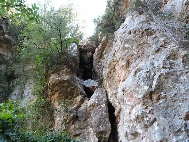
A 69 m deep pit in a major fracture at Pratdip (Baix Camp), in the Cingles de la Grallera, with a joint-controlled upper entrance and lower entrances.
Topographic

Espeleoindex · CC BY-NC 4.0, https://creativecommons.org/licenses/by-nc/4.0/ · Image © its author.
Photos

Espeleoindex · CC BY-NC 4.0, https://creativecommons.org/licenses/by-nc/4.0/ · Image © its author.
Description
Morphology
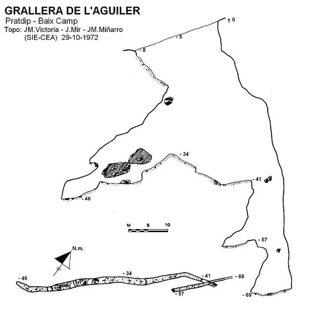
The upper entrance (Grallera de l'Aguiler) has a joint-controlled appearance with a length of about 20 metres. Almost in its central zone the descent of the entrance shaft begins, which reaches a depth of 34 metres. From its base and in a SW direction, a gallery begins which, among blocks and with some small steps, reaches a depth of 46 metres.
Again at the base of the entrance shaft and in a NE direction, a gallery 22 metres long begins, leading to a new vertical drop, of 16 metres, which opens onto a short gallery that, at one of its ends, begins a narrow shaft where the maximum depth level is reached (- 69).
Below the main entrance there are two more entrances (Avenc de l'Ortiguer), one in the form of a shaft and another, 10 metres further down, in the form of an inclined gallery that connects within a few metres with the upper shaft. At the bottom of this, among blocks, one can still descend a step that places us at 54.6 metres depth with respect to the highest point of the upper entrance. From this point, the gallery, narrow and made uneven by large blocks wedged between the walls, climbs slightly until it links up with level - 46 of the gallery coming from the main shaft of the upper entrance.
Typical cavity of tectonic origin set in a large fracture of NE – SW direction, produced by the gravitational displacement of the limestone mass.
History
The first news we have about the cavity is that provided by members of the SIE – CEA who explored and surveyed it on 29 October 1972, entering through the upper entrance and reaching the point of maximum depth. The Pratdip local who accompanied them informed them that the cavity is known as Grallera de l'Aguiler and did not indicate the existence of the lower entrances to them, nor did they manage to see the internal connection with these.
Two years later, in November 1974, members of the GE Pedraforca explored the cavity again and located the three entrances. The explorations and survey were considered finished in 1977 by members of the ERE – CEC. It is published under the name Avenc de l'Ortiguer.
Searching for information on the matter we find in a collection of activities of the GIE – CE Gràcia, that in February 1968 they had explored at Pratdip the Cova-avenc de l'Hortiguer, as recorded in the bulletin of the Club Excursionista de Gràcia, and they attribute to it 40 metres of depth and 60 metres of passage. This is all the meagre information that could be gathered from that exploration. But the depth data coincide with the cavity that develops from the lower entrances, one in the form of a shaft and the other in the form of a cave, which we must suppose gave rise to calling it cova-avenc. Apparently, in that first partial exploration, and unlike those of the SIE, they did not find the connection with the galleries coming from the upper entrance and apparently not even this one.
During the preparation of the Catàleg Espeleològic de Catalunya (Vol. 7; 1984) a somewhat Solomonic solution was chosen: the upper entrance was given the name Grallera de l'Aguiler and the lower ones that of Avenc de l'Ortiguer and here we have decided to do the same.
To complicate matters further, on the Serra de Llaberia map (Ed. Piolet) they appear marked with both names and, further N, on the same cliff they mark another cavity with the name Forat de l'Ortiguer and about which, if it is not an error for duplication, we have no information.
User Comments (0)
No comments yet.
Be the first to share your experience!
Registered Explorations (0)
No explorations registered yet.
Register your visit to this cave!
Bibliography
- Borràs, J.; Miñarro, JM.; Talavera, F. (1984).-Catàleg espeleològic de Catalunya. Vol. 7 (el Baix Camp, el Priorat i la Ribera d'Ebre). Políglota: 283 pp. Barcelona.
- Miñarro, JM.; Lázaro, P. (1977).- “Breves notas descriptivas sobre algunas cavidades de la Serra de Llaberia (Baix Camp, T).” EspeleoSie (20): 45-63. SIE del CE Àliga. Barcelona.
- Montserrat, A. (1979).- “Sobre algunes cavitats de les comarques del Baix Camp i Priorat”. Espeleòleg (28): 489-530. ERE del CEC. Barcelona.
- Actualització de fitxa juny 2020. Coordenades i foto de Antonieta Freixas, extret de (wikiloc.com) post del dia 28-05-2017.
Nearby caves
Source: Espeleoindex (espeleoindex.com), modified. CC BY-NC 4.0, https://creativecommons.org/licenses/by-nc/4.0/