
Avenc dels Arcs
Sinkhole of the riera de Jafre, in the Garraf, penetrable to a depth of 14 m.
EspeleoWorld
Avenc dels Arcs
Sinkhole of the riera de Jafre, in the Garraf, penetrable to a depth of 14 m.
Sant Pere de Ribes · Garraf
Length: 20 m · Depth: 14 m
Updated record
https://espeleoworld.com/en/c/avenc-dels-arcs
Information can change. Always verify coordinates, access, weather, and cave conditions before setting out.
Sinkhole of the riera de Jafre, in the Garraf, penetrable to a depth of 14 m.
Topographic
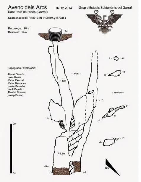
Espeleoindex · CC BY-NC 4.0, https://creativecommons.org/licenses/by-nc/4.0/ · Image © its author.
Photos
Espeleoindex · CC BY-NC 4.0, https://creativecommons.org/licenses/by-nc/4.0/ · Image © its author.
Description
Morphology
The mouth, protected by a corrugated tube, allows entry into a 10-metre shaft. At its bottom, on one side, an ascending passage begins that almost reaches the level of the mouth, but halfway along there is a passage that connects with a descending one, very narrow, which at its bottom connects with the point plugged by gravel and which is reached from a 3.5-metre drop at the bottom of the entrance shaft. This passage is also plugged by gravel and is the current point of maximum penetration, awaiting a possible clearing that could give access to the shafts that had been explored in 1978.
Progression
The mouth, protected by a corrugated tube, allows entry into a 10-metre shaft. At its bottom, on one side, an ascending passage begins that almost reaches the level of the mouth, but halfway along there is a passage that connects with a descending one, very narrow, which at its bottom connects with the point plugged by gravel and which is reached from a 3.5-metre drop at the bottom of the entrance shaft.
History
It seems that this pit appeared due to the work of a machine that was levelling the riera to make a water well or for gravel extraction. The first news we have about this cavity is provided by the members of the ephemeral group of associates that the GES – CMB had in Olesa de Bonesvalls, who explored it in 1978 and according to the survey that was published the following year had reached 70 metres of depth.
A few months later, members of the SIE – CEA visit it and were able to descend to about 40 metres of depth where they found that the continuation was completely flooded. Later, speleologists from Vilanova and Ribes also visit it, but it seems that they do not get past the first shaft or little more and they had also found the water level very high. A large stone block was even placed at the mouth to prevent it from being plugged by the drag of the riera, which in time became inevitable.
The years pass and despite the many searches that had been made along the bed of the riera it had been impossible to find it again.
Some knew it by the name of Avenc de la Riera and that is how it appears marked on the ICGC map.
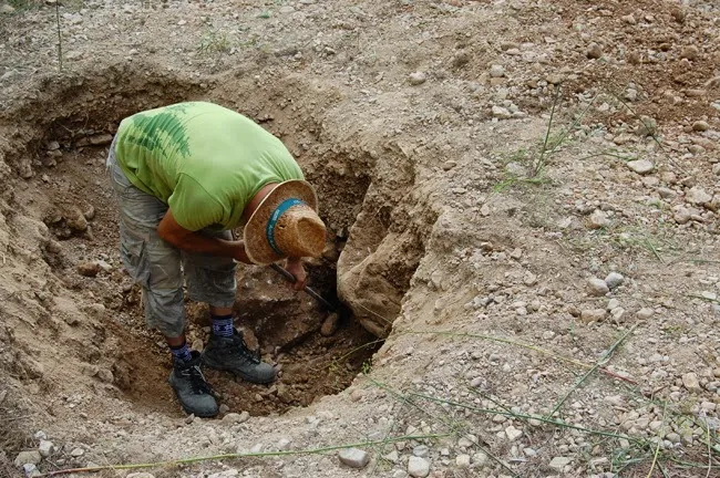
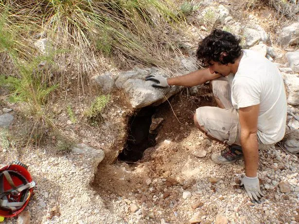
It is not until the summer of 2014 that, members of the GES-Garraf, with the help of a photograph from 1983 provided by a former member of the Talaia de Vilanova can, despite the change in the appearance of the riera over the years, sense the specific point where the pit must have been. With much luck and after more than two hours of digging, they can find the mouth of the pit again. Later they can explore it to 14 metres of depth where it remains plugged and pending future clearings. To prevent the mouth from becoming covered again they have installed a corrugated tube at the mouth of the pit.
User Comments (0)
No comments yet.
Be the first to share your experience!
Registered Explorations (0)
No explorations registered yet.
Register your visit to this cave!
Bibliography
- GES (1979).- “Dues noves cavitats explorades pel GES d'Olesa de Bonesvalls (Massís de Garraf)”. Circular del Club Muntanyenc Barcelonès (gener-juny): 395-396. Club Muntanyenc Barcelonès.
- Totes les dades, topografia actual i fotografies han estat extretes del blog: ges-garraf.blogsport (apunt del dia 11 de desembre del 2011). (Grup d'Estudis Subterranis del Garraf).
Nearby caves


Source: Espeleoindex (espeleoindex.com), modified. CC BY-NC 4.0, https://creativecommons.org/licenses/by-nc/4.0/