
Bilsteinhöhle
The Bilsteinhöhle is a Höhlensystem (cave system) in the Arnsberger Wald Nature Park in North Rhine-Westphalia, Germany, with a show cave and other cave sections, some of which are connected to it.
EspeleoWorld
Bilsteinhöhle
The Bilsteinhöhle is a Höhlensystem (cave system) in the Arnsberger Wald Nature Park in North Rhine-Westphalia, Germany, with a show cave and other cave sections, some of which are connected to it.
Warstein
الطول: 1700 m
السجل المحدّث
https://espeleoworld.com/ar/c/bilsteinhoehle-warstein
قد تتغير المعلومات. تحقق دائمًا من الإحداثيات والوصول والطقس وظروف الكهف قبل الانطلاق.
The Bilsteinhöhle is a Höhlensystem (cave system) in the Arnsberger Wald Nature Park in North Rhine-Westphalia, Germany, with a show cave and other cave sections, some of which are connected to it.
الصور
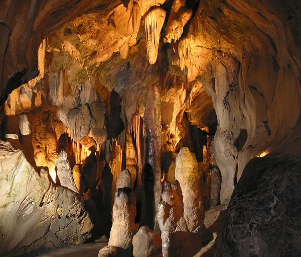
© Stefan Enste at de.wikipedia · CC BY-SA 2.0 DE, https://creativecommons.org/licenses/by-sa/2.0/de/ · Wikimedia Commons · https://commons.wikimedia.org/wiki/File:Bilsteinhoehle_Warstein,_Halle_der_60_Riesen.jpg
الوصف
الشكل
The Bilsteinhöhle is a Höhlensystem (cave system). In addition to the show cave, there are other cave sections, some of which are connected with the show cave.
تعليقات المستخدمين (0)
لا توجد تعليقات بعد.
كن أول من يشارك تجربته!
الاستكشافات المسجلة (0)
لا توجد استكشافات مسجلة بعد.
سجل زيارتك لهذا الكهف!
الكهوف القريبة


المصدر: Geotopkataster Nordrhein-Westfalen (Geologischer Dienst NRW) (ogc-api.nrw.de)، مع تعديلات. Data licence Germany – attribution – version 2.0 (dl-de/by-2-0), https://www.govdata.de/dl-de/by-2-0 Geowissenschaftliche Daten: INSP-GeotopeinNRW @ Geologischer Dienst NRW · بيانات عام 2026 · يحتوي على معلومات من Grottocenter (Wikicaves)، grottocenter.org، متاحة بموجب رخصة قاعدة البيانات المفتوحة (Open Database License، ODbL 1.0, https://opendatacommons.org/licenses/odbl/1-0/)، مع تعديلات. · الطول · تم الحصول عليها في 2026-11-13 · https://grottocenter.org/ui/entrances/23571 · بيانات عام 2026 · يحتوي على معلومات من © OpenStreetMap contributors، www.openstreetmap.org، متاحة بموجب رخصة قاعدة البيانات المفتوحة (Open Database License، ODbL 1.0, https://opendatacommons.org/licenses/odbl/1-0/)، مع تعديلات. · https://www.openstreetmap.org/node/416932490 · بيانات عام 2026 · المصدر: Wikidata – cave items (Germany) (www.wikidata.org)، مع تعديلات. CC0 1.0, https://creativecommons.org/publicdomain/zero/1.0/ Wikidata (CC0 1.0) · بيانات عام 2026 · المصدر: German Wikipedia – article leads (cave descriptions) (de.wikipedia.org)، مع تعديلات. CC BY-SA 4.0, https://creativecommons.org/licenses/by-sa/4.0/ Wikipedia contributors (de.wikipedia.org), CC BY-SA 4.0 · النص بقلم Wikipedia contributors (Bilsteinhöhle) · عدّلته Espeleoworld (توحيد الصيغة، ترجمة)؛ التعديل مرخّص بموجب CC BY-SA 4.0, https://creativecommons.org/licenses/by-sa/4.0/ · الوصف · تم الحصول عليها في 2026-11-13 · https://de.wikipedia.org/wiki/Bilsteinh%C3%B6hle · بيانات عام 2026 · بيانات الموقع: © OpenStreetMap contributors، ODbL 1.0, https://opendatacommons.org/licenses/odbl/1-0/. · https://www.openstreetmap.org/node/416932490 · البيانات المشتقة متاحة عند الطلب بموجب ODbL: [email protected]