
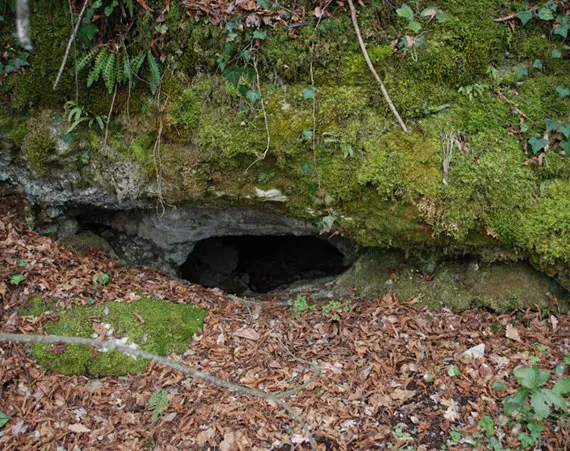
Buche del Vento
A cave with horizontal development and easy traversability, whose entrance is a fissure through which, descending a small drop, one enters the section cleared over the years by the Gruppo Speleologico Todi.
EspeleoWorld
Buche del Vento
A cave with horizontal development and easy traversability, whose entrance is a fissure through which, descending a small drop, one enters the section cleared over the years by the Gruppo Speleologico Todi.
Baschi
Длина: 15 m · Глубина: 4 m
Актуальная запись
https://espeleoworld.com/ru/c/buche-del-vento-baschi-terni
Информация может меняться. Перед выходом всегда проверяйте координаты, доступ, погоду и состояние пещеры.
A cave with horizontal development and easy traversability, whose entrance is a fissure through which, descending a small drop, one enters the section cleared over the years by the Gruppo Speleologico Todi.
Фотографии

© Gruppo Speleologico Todi · LicenseRef-FUGS-media-per-item · Federazione Umbra Gruppi Speleologici (FUGS), Catasto Speleologico dell'Umbria · https://catasto.fugs.it/index.php?mod=caves&op=view&id=1023
Описание
Морфология
The entrance is a natural fissure; descending a small drop, one enters the internal route. Trend: horizontal.
Прохождение
From the narrow passage one descends a small drop and enters the section cleared over the years by the Gruppo Speleologico Todi. Traversability: easy; recommended period: all year.
Другие сведения
The first clearing operations took place in the years 1979-1980 with the collaboration of two "clearing" speleologists from Sarteano. From the cavity, hence the name, a strong draft of air blows, channeled into small conduits.
История
The place name, already present in IGM cartography, has always been known to the local inhabitants. The path was in fact frequented because it allowed one to reach the sanctuary of the Pasquarella.
Комментарии пользователей (0)
Комментариев пока нет.
Станьте первым, кто поделится своим опытом!
Зарегистрированные исследования (0)
Зарегистрированных исследований пока нет.
Зарегистрируйте свое посещение этой пещеры!
Ближайшие пещеры
Источник: Catasto Cavità Umbria (Federazione Umbra Gruppi Speleologici, FUGS) (catasto.fugs.it), с изменениями. LicenseRef-FUGS-no-licence-stated Federazione Umbra Gruppi Speleologici (FUGS), Catasto Speleologico dell'Umbria · https://catasto.fugs.it/index.php?mod=caves&op=view&id=1023 · данные на 2025 г. · Источник: Catasto Cavità Umbria (Federazione Umbra Gruppi Speleologici, FUGS) (catasto.fugs.it), с изменениями. LicenseRef-FUGS-media-per-item Federazione Umbra Gruppi Speleologici (FUGS), Catasto Speleologico dell'Umbria · данные на 2025 г.