
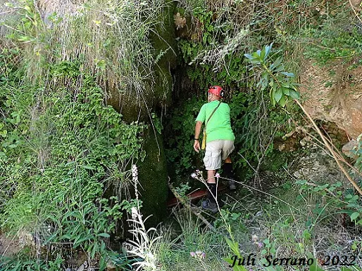
Tosca dels Escanals
Small cavity developed in travertines at the Tosca dels Escanals, in la Febró.
EspeleoWorld
Tosca dels Escanals
Small cavity developed in travertines at the Tosca dels Escanals, in la Febró.
Febró, La · Baix Camp
Sviluppo: 6 m · Profondità: 1 m
Scheda aggiornata
https://espeleoworld.com/it/c/tosca-dels-escanals
Le informazioni possono cambiare. Verifica sempre coordinate, accesso, meteo e condizioni della cavità prima di partire.
Small cavity developed in travertines at the Tosca dels Escanals, in la Febró.
Topografia

Espeleoindex · CC BY-NC 4.0, https://creativecommons.org/licenses/by-nc/4.0/ · Immagine © del suo autore.
Foto
Espeleoindex · CC BY-NC 4.0, https://creativecommons.org/licenses/by-nc/4.0/ · Immagine © del suo autore.
Descrizione
Morfologia
Small cavity developed in the space left behind the flowstone resulting from the contribution of travertines.
Idrologia
The waters come from two small ravines, the Canals del Mas d'en Bella, which join shortly before forming the waterfall of the Tosca dels Escanals.
Storia
In the past, the waters of the Canals del Mas d'en Bella were conducted to the other bank of the Siurana by means of a hollowed-out trunk, in order to feed the collection point of the nearby Molí de la Febró.
Commenti degli utenti (0)
Nessun commento ancora.
Sii il primo a condividere la tua esperienza!
Esplorazioni registrate (0)
Nessuna esplorazione registrata.
Registra la tua visita a questa grotta!
Bibliografia
- Manent, Albert (1967).- Toponímia del terme municipal de la Febró. (Premi Eduard Brossa 1968 de la Societat Catalana de Geografia). Butlletí Arqueològic. Reial Societat Arqueològica Tarraconense, 1973, Núm. 121-128, p. 163-192.
- Dades extretes de blog (blocs.tinet.cat/lt/blog/archive/179/2009/08/)
- Dades, coordenades, situació, topografia i fotografies facilitades per Juli Serrano (SIE-CEA) i Francesc Rubinat (ERE-CEC).
Grotte vicine


Fonte: Espeleoindex (espeleoindex.com), modificato. CC BY-NC 4.0, https://creativecommons.org/licenses/by-nc/4.0/