
Horat Der Uelh Deth Tor
A 169-metre-deep pit in the Vall d'Aran, a swallow hole for a small stream coming from a tarn located some 250 metres to the N. Explored since 1977, with a total length of 1,718 m.
EspeleoWorld
Horat Der Uelh Deth Tor
A 169-metre-deep pit in the Vall d'Aran, a swallow hole for a small stream coming from a tarn located some 250 metres to the N. Explored since 1977, with a total length of 1,718 m.
Vielha e Mijaran · Val d'Aran
Sviluppo: 1718 m · Profondità: 169 m
Scheda aggiornata
https://espeleoworld.com/it/c/horat-der-uelh-deth-tor
Le informazioni possono cambiare. Verifica sempre coordinate, accesso, meteo e condizioni della cavità prima di partire.
A 169-metre-deep pit in the Vall d'Aran, a swallow hole for a small stream coming from a tarn located some 250 metres to the N. Explored since 1977, with a total length of 1,718 m.
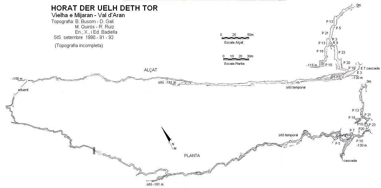
Topografia
Espeleoindex · CC BY-NC 4.0, https://creativecommons.org/licenses/by-nc/4.0/ · Immagine © del suo autore.
Foto
Espeleoindex · CC BY-NC 4.0, https://creativecommons.org/licenses/by-nc/4.0/ · Immagine © del suo autore.
Descrizione
Morfologia
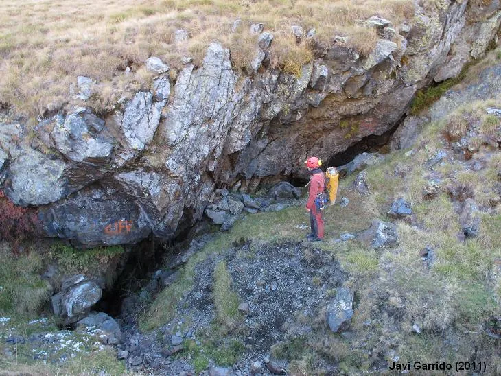
The entrance to the cavity is in the rock shelter formed by the W wall of the funnel, and it takes the form of a somewhat low gallery, covered with blocks and with an increasingly pronounced slope. The gallery narrows and progress becomes uncomfortable because of the schistous ground. The first sections of the cavity, down to the bottom of the first pit (Pou Esquistós), are excavated in schists and the rest in Ordovician marbles. The elongated chamber through which a noisy river flows is 5X17 metres and 6 high. The meandering gallery is 2 to 2.5 metres wide by 1 to 2 high. The ceiling rises and reaches 3 metres in height. The small chamber 4 metres in diameter is full of blocks. The chamber 5 metres in diameter is completely flooded.
Idrologia
In the funnel that forms the entrance of the pit there is a loss of water through which the stream coming from the small tarn located to the west of the plan deth Tor seeps. On the ledge of the pou de l'Esperança, descending by the ramp of the Cul de Sac, a crawl in an E direction reaches an impenetrable small stream. The meander through which the water flows: upstream, one reaches a 7-metre chimney from which the water comes in the form of a waterfall; downstream, a watered 10-metre pit, at the floor of which, at -130 metres, the water is lost through an impenetrable crawl. The widest gallery through which a river flows is the main active course of the whole cavity. At -130 metres, after 8 metres of passage, a 7-metre pit leads back to the main river. A narrow crawl on the left leads to a chamber 7 metres above its floor. The noisy river flows through an elongated chamber 5X17 metres and 6 high, which rises among blocks up to some waterfalls of 1, 3, 1 and 7 metres; the last waterfall has not yet been overcome. Downstream, the river is obstructed by blocks, but through a descending crawl among the debris the river is found again, following a meandering gallery 2 to 2.5 metres wide by 1 to 2 high. The river is lost on the left and the gallery lowers and narrows until it forms an earthy crawl, quite committing, since in the event of a rise in the water the loss surely cannot swallow all the water and the crawl floods. The river continues in the form of a tube for some 110 metres, until a last stretch of 20 metres where some slabs narrow the gallery, before reaching the final small chamber where there is the sump through which the river is lost. The cavity reaches its maximum depth of -169 metres.
Progressione
After two drops and at 22 metres of depth, we find the mouth of the first pit, called pou Esquistós, 13 metres deep. At its base, a low vault where we make the re-rig gives access to a 5-metre drop, where the schist rock gives way to limestone and marbles. Having descended the drop, a 21-metre pit appears, the pou Tània, with a ledge at 17 metres. Then there is a 3-metre drop and we enter the pou de l'Esperança. At 4 metres of pit and at -66 depth there is a ledge that bifurcates the pou de l'Esperança to the W, and a ramp to the E followed by a 9-metre drop that leads to the Via Nova. Following the Via dels francesos and having descended the 13 metres of the pou de l'Esperança, we find a low passage that leads to a 2-metre drop that immediately precedes the pou Jacques, 18 metres. In this we find a ledge halfway down the pit that forms a dangerous edge, not very visible because of the blackness of the rock. Having descended this pit, a 5-metre crawl is born that gives onto an aerial 6-metre pit, at the base of which a low gallery connects us with three 10-metre pits, all of them open onto the narrow final gallery. This last gallery ends in a narrow drop that becomes impenetrable at -115 metres of depth. Returning to the ledge of the pou de l'Esperança and descending by the ramp of the Cul de Sac, we find a crawl that in an E direction reaches an impenetrable small stream, and in a W direction, overcoming a rather narrow passage, one reaches, after a 1-metre drop, the pou Montse, 23 metres. This presents a ledge at 7 metres, and the first drips already affect us. Next appears the pou Helena, 20 metres, with a succession of drops of 4.5, 3.5, 7 and 5 metres respectively, until giving onto a meander through which the water flows. Upstream, one quickly reaches a 7-metre chimney from which the water comes in the form of a waterfall. Downstream, we find a watered 10-metre pit, at the floor of which, at -130 metres, the water is lost through a crawl, for now impenetrable. The cavity continues through a 30-metre gallery, which gives onto a 5-metre pit, followed by a meander that gives onto a wider gallery through which a river flows. Some 5 metres before the last pit, there is a crawl from which comes the small stream that plunges down the pit. Returning to the start of the gallery, at -130 metres, and after 8 metres of passage we find a 7-metre pit that leads back to the main river. We can also reach this through a narrow crawl that we find on the left, a few metres before, which leads to a chamber 7 metres above its floor. The most advisable is to descend by the first of the 7-metre pits, which we find on the right, and we will reach a small chamber 4 metres in diameter, full of blocks, from which we access through a low passage an elongated chamber through which a noisy river flows. The chamber, 5X17 metres and 6 high, rises among blocks, until, upstream, we find some waterfalls of 1, 3, 1 and 7 metres. This last waterfall has not yet been overcome, and we will have to wait for a time of greater drought. If we follow downstream, it is obstructed by blocks, but through a descending crawl, among the debris, we find the river again which, from now on, follows a meandering gallery 2 to 2.5 metres wide by 1 to 2 high, with some lower passages. We follow downstream until we find a series of drops in the form of small waterfalls that lead to a chamber 5 metres in diameter, completely flooded. The river continues through a lower gallery, but it is advisable to follow an elevated gallery climbing some 2 metres to avoid the wetness. We quickly return to the river after 4 metres, descending an easy ramonage. Next, the river is lost on the left and the gallery lowers and narrows until it forms an earthy crawl, quite committing, since in the event of a rise in the water, the loss surely cannot swallow all the water and the crawl floods. Again, the ceiling rises, reaches 3 metres in height and we find the river again. The gallery forms meanders until reaching a 4-metre pit, where the river plunges in a waterfall. Having descended this, the river continues in the form of a tube and advances very comfortably some 110 metres, until a last stretch of 20 metres, where some slabs narrow the gallery, before reaching the final small chamber where there is the sump through which the river is lost. Here the cavity reaches its maximum depth of -169 metres. Returning some 20 metres back from the river, we see two elevated galleries. The left one, looking downstream, is an upper level of the river until it gives onto the small chamber of the terminal sump. The right gallery is earthy and seems fossil, one can advance without difficulty some 105 metres of passage, and from there on - where for the moment the survey ends - the gallery becomes a muddy crawl that becomes impenetrable at 100 more metres of passage.
Altri dettagli
From then on, and in the course of the last years 1993-2007, various explorations have been carried out in which various sections have been surveyed and revised both above the waterfall and the crawls downstream, notably extending the horizontal development, reaching a total length of 1,718 m, but with a depth practically identical to the first surveys of the river galleries; -169m. It does not seem that the end of the cavity has been reached, since the crawls narrow and flood making the exploration really hard. Note from the Espeleoíndex team: The only survey available seems to correspond to 1018 metres of passage and the maximum depth point is placed at -161 m. Apparently, the 700 metres more of passage that the cavity has correspond to an estimated calculation based on later survey work, which remains unpublished and which has possibly been lost. Toponymy: The first explorers of the cavity (GSP) named it Güell del Thur, (they put the diaeresis over the ë) based on a toponym that appeared in the Vall d'Aran maps of Editorial Alpina in the editions of the 1970s and which apparently referred (as its own name indicates: güell) to a spring that originated a small watercourse and which, after feeding a small tarn, was lost a little further on in the cavity (that is, a swallow hole, the complete opposite of güell). Subsequently, the cavity has been mentioned with different variants of the original word until it seemed that the most correct would be Uelh deth Tur. But if uelh is the Aranese name for spring, source, etc., we believe that the correct thing would be to call it Horat der Uelh deth Tor and change Tur for Tor since the official toponymy (not always entirely correct) indicates Tor (a fairly frequent word in the Catalan Pyrenees) instead of Tur.
Storia
On 16 August 1977, Yves Besset (G.S.Pyrénées, Toulouse) during a prospection in the vall d'Unhola, located the cavity and made a first entry down to 15 metres of depth, where a rather narrow passage stopped him. A month later, on 11 September, together with other companions from the GSP, they dug open the narrow passage and explored the cavity as far as the pou Jacques which they did not descend for lack of equipment. On 30 October of the same year they return and can descend as far as the start of the pou de la Tempesta. They had already passed the hundred metres and the cavity continued vertically. But it is not until 31 August of the following year that they were able to finish the exploration and produce a first survey. On 18 June 1990, four members of the SIS of the CE Terrassa, motivated by the exploration of the French, decide to visit the cavity. When they reached the pou de l'Esperança (level -66), Xavi Badiella who was going first, while waiting for the others to descend, climbed down the so-called Cul de Sac, and the surprise was that, on both sides of the floor, two crawls started. One very narrow at first, while the other, although one had to drag oneself quite a bit, he verified was passable, and he entered it, realising that it led to a notable pit. Convinced that the continuation of the cavity was on that side -since according to the French speleologists one had to overcome a passage narrowed by a boulder to reach the pou Jacques- he warned the other companions to follow him. At that time they did not know that the pit descended that day was totally unknown, but there were doubts about it. These were dispelled on 30 July when they returned and descended the pits described by the French and via the Via Nova were able to reach the river. That summer and until mid-October (on almost weekly trips) they went on progressing in the exploration, each time with more difficulties in the advance. The explorations and survey were continued on different days throughout the summers of 1991 and 1992.
Commenti degli utenti (0)
Nessun commento ancora.
Sii il primo a condividere la tua esperienza!
Esplorazioni registrate (0)
Nessuna esplorazione registrata.
Registra la tua visita a questa grotta!
Bibliografia
- Besset, Y. (1977).- “Spéléologie au Val d'Aran (Espagne)” Ouarnède (9): 57-73. Grouppe Spéléologique des Pyrénées. Toulouse.
- Cardona, F. (1990).- Grans cavitats de Catalunya. Vol 1: La Serralada Pirinenca. 198 pp. Espeleo Club de Gràcia. Barcelona.
- Quirós, M.; Galí, D.; Badiella, X.; Badiella, E. (1992).- “Uelh d'eth Tur” SIS (12): 73-84 / Arxiu del Centre Excursionista de Terrassa (75): 209-220. Terrassa.
· Web del Centre Excursionista de Terrassa (actualització de les darreres exploracions (2003-2007).
· Fotografies facilitades per Javi Garrido (ERE del CEC)
Grotte vicine


Fonte: Espeleoindex (espeleoindex.com), modificato. CC BY-NC 4.0, https://creativecommons.org/licenses/by-nc/4.0/