
Balma del Pademí
A 17 m long rock shelter in Castellcir (Moianès), traversed by the torrent, rediscovered in 2015.
EspeleoWorld
Balma del Pademí
A 17 m long rock shelter in Castellcir (Moianès), traversed by the torrent, rediscovered in 2015.
Castellcir · Moianès
Sviluppo: 17 m
Scheda aggiornata
https://espeleoworld.com/it/c/balma-del-pademi
Le informazioni possono cambiare. Verifica sempre coordinate, accesso, meteo e condizioni della cavità prima di partire.
A 17 m long rock shelter in Castellcir (Moianès), traversed by the torrent, rediscovered in 2015.
Topografia
Espeleoindex · CC BY-NC 4.0, https://creativecommons.org/licenses/by-nc/4.0/ · Immagine © del suo autore.
Foto
Espeleoindex · CC BY-NC 4.0, https://creativecommons.org/licenses/by-nc/4.0/ · Immagine © del suo autore.
Descrizione
Morfologia
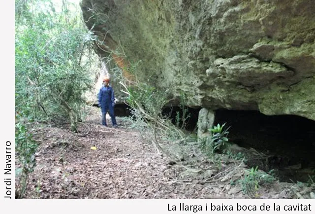
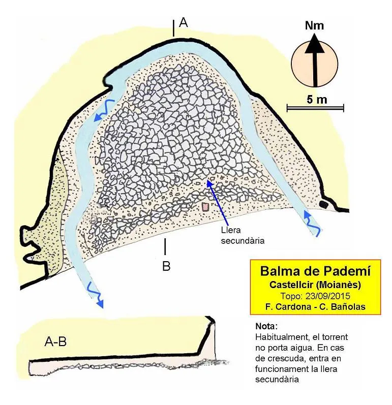
Rock shelter 26 metres wide by 17 deep, with a very low ceiling. The maximum height is 1.60 metres, so throughout it we must advance either crouching or crawling. The ceiling of the cavity is very flat, coinciding with a bedding plane. The surface area of the whole concavity is about 250 square metres.
Idrologia
The most notable feature is that the whole cavity is traversed by the torrent. It enters at the eastern end and exits at the western end. Inside, it covers a distance of 45 metres, drawing a great meander of almost 180 degrees.
Normally, the torrent carries no water, being active after the rains. If it rises, the water can overflow the meander channel and a secondary channel comes into operation that acts as a shortcut of the meander, leaving in the middle an island that we find full of pebbles, gravel and plant remains dragged by the great floods, when the water can flood the entire surface of the cavity. In the whole area of the "island" the height of the cavity is very reduced, often not exceeding 30-40 centimetres.
The torrent has eroded the weak materials that lie below the harder stratum that forms the ceiling of the cavity, burrowing beneath it. The meander, in its evolution, has progressively deepened until reaching the current situation.
Storia
The name of the rock shelter appears lettered on the ICC map. It also appears in the "Recull onomàstic de Castellcir". However, it has gone unnoticed from the speleological point of view, not appearing in any catalogue. The cavity was recently rediscovered (2015) by friends Jordi Navarro and Montse Mañosa, of the Centre Excursionista de Castellar del Vallès.
Commenti degli utenti (0)
Nessun commento ancora.
Sii il primo a condividere la tua esperienza!
Esplorazioni registrate (0)
Nessuna esplorazione registrata.
Registra la tua visita a questa grotta!
Bibliografia
- Totes les dades, topografia i fotografies han estat extretes del blog: cavitatsdecatalunya.blogspot (de Jordi de Valles). Apunt del 24-10-2015. Autor fitxa: Ferran Cardona (EC Gràcia)
Grotte vicine


Fonte: Espeleoindex (espeleoindex.com), modificato. CC BY-NC 4.0, https://creativecommons.org/licenses/by-nc/4.0/